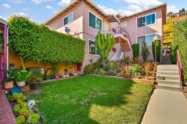
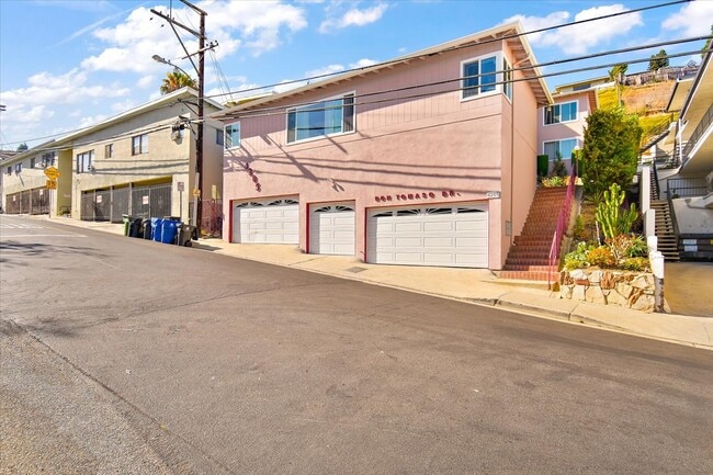
Property Record
4205 Don Tomaso Dr, Los Angeles, CA 90008

NEARBY LISTINGS FOR SALE OR LEASE
Property Detail
4205 Don Tomaso Dr
Los Angeles-Long Beach-Glendale, CA
14641
5026-014-006
TRACT # 14641 LOT 40
Multifamilydwelling
Los Angeles
X
California
06037C1613G
40
2024
0.20 AC
2025
Crenshaw
236400
Los Angeles
4,708 SF
DEMOGRAPHICS near 4205 Don Tomaso Dr
1 Mile
3 Mile
5 Mile
2024 Total Population
31,683
318,120
1,049,067
2029 Population
31,025
309,155
1,017,701
Pop Growth 2024-2029
(2.08%)
(2.82%)
(2.99%)
Average Age
42
40
39
2024 Total Households
13,279
115,036
380,674
HH Growth 2024-2029
(2.36%)
(2.99%)
(3.01%)
Median Household Inc
$55,000
$65,076
$65,960
Avg Household Size
2.30
2.70
2.60
2024 Avg HH Vehicles
1.00
2.00
2.00
Median Home Value
$950,682
$812,081
$887,524
Median Year Built
1955
1952
1956
Nearby Places
Map Layers
Map Styles
 Street
 Aerial
- Restaurants
- Banks
- Shops
- Fitness
- Groceries
PUBLIC TRANSPORTATION
TRANSIT/SUBWAY
Martin Luther King Jr Station (Metro K-Line - Metro - Los Angeles)
DRIVE
WALK
Distance
Martin Luther King Jr Station (Metro K-Line - Metro - Los Angeles)
2 min
17 min
0.9 mi
COMMUTER RAIL
Los Angeles (Coast Starlight - Amtrak, Pacific Surfliner - Amtrak, Southwest Chief - Amtrak, Texas Eagle - Amtrak)
DRIVE
WALK
Distance
Los Angeles (Coast Starlight - Amtrak, Pacific Surfliner - Amtrak, Southwest Chief - Amtrak, Texas Eagle - Amtrak)
16 min
8.3 mi
Union Station (91 Line - Southern California Regional Rail Authority (Metrolink), Antelope Valley Line - Southern California Regional Rail Authority (Metrolink), Orange County Line - Southern California Regional Rail Authority (Metrolink), Riverside Line - Southern California Regional Rail Authority (Metrolink), San Bernardino Line - Southern California Regional Rail Authority (Metrolink), Ventura County Line - Southern California Regional Rail Authority (Metrolink))
DRIVE
WALK
Distance
Union Station (91 Line - Southern California Regional Rail Authority (Metrolink), Antelope Valley Line - Southern California Regional Rail Authority (Metrolink), Orange County Line - Southern California Regional Rail Authority (Metrolink), Riverside Line - Southern California Regional Rail Authority (Metrolink), San Bernardino Line - Southern California Regional Rail Authority (Metrolink), Ventura County Line - Southern California Regional Rail Authority (Metrolink))
18 min
8.6 mi
AIRPORT
Los Angeles International
DRIVE
WALK
Distance
Los Angeles International
13 min
6.7 mi
Bob Hope
DRIVE
WALK
Distance
Bob Hope
30 min
17.2 mi
Long Beach (Daugherty Field)
DRIVE
WALK
Distance
Long Beach (Daugherty Field)
31 min
23.1 mi
Freight Ports
Port of Long Beach
DRIVE
WALK
Distance
Port of Long Beach
34 min
25.0 mi
SALE & LEASE HISTORY
LISTING DATE
SALE/LEASE

Aug 17, 2023
For Sale
Nearby Properties
Address
Land Use
TOTAL SIZE
Lot Size
Zoning
Address
Land Use
TOTAL SIZE
Lot Size
Zoning
597,713 SF
11.18 AC
CCS1YY
Address
Land Use
TOTAL SIZE
Lot Size
Zoning
871,235 SF
14.56 AC
LAC2
Address
Land Use
TOTAL SIZE
Lot Size
Zoning
368,411 SF
10.91 AC
C2-2D-CPIO
Address
Land Use
TOTAL SIZE
Lot Size
Zoning
670,596 SF
11.60 AC
LAR4
Address
Land Use
TOTAL SIZE
Lot Size
Zoning
78,793 SF
3.53 AC
LAMR1
Address
Land Use
TOTAL SIZE
Lot Size
Zoning
274,892 SF
3.53 AC
CCC3EY
Address
Land Use
TOTAL SIZE
Lot Size
Zoning
297,937 SF
1.59 AC
CCC3*
Address
Land Use
TOTAL SIZE
Lot Size
Zoning
127,537 SF
1.16 AC
CCC3YY
Address
Land Use
TOTAL SIZE
Lot Size
Zoning
530,660 SF
20.58 AC
CCC3*
Address
Land Use
TOTAL SIZE
Lot Size
Zoning
249,132 SF
2.31 AC
CCC3*
Address
Land Use
TOTAL SIZE
Lot Size
Zoning
304,968 SF
3.07 AC
CCC3*
Address
Land Use
TOTAL SIZE
Lot Size
Zoning
106,000 SF
4.26 AC
LAMR 1
Address
Land Use
TOTAL SIZE
Lot Size
Zoning
237,673 SF
3.73 AC
M1-2D-CPIO
Address
Land Use
TOTAL SIZE
Lot Size
Zoning
128,347 SF
2.83 AC
LACM
Address
Land Use
TOTAL SIZE
Lot Size
Zoning
73,918 SF
3.86 AC
LAM1
Address
Land Use
TOTAL SIZE
Lot Size
Zoning
175,479 SF
1.63 AC
CCC3VV
Address
Land Use
TOTAL SIZE
Lot Size
Zoning
31,358 SF
5.43 AC
LAMR
Address
Land Use
TOTAL SIZE
Lot Size
Zoning
102,877 SF
8.69 AC
LAC2
Address
Land Use
TOTAL SIZE
Lot Size
Zoning
343,879 SF
4.26 AC
LAC2
Address
Land Use
TOTAL SIZE
Lot Size
Zoning
214,155 SF
3.33 AC
CCM1
Address
Land Use
TOTAL SIZE
Lot Size
Zoning
285,718 SF
2.08 AC
CCC3*
Address
Land Use
TOTAL SIZE
Lot Size
Zoning
569,916 SF
10.69 AC
LAR3
Address
Land Use
TOTAL SIZE
Lot Size
Zoning
203,272 SF
14.53 AC
LAC2
Address
Land Use
TOTAL SIZE
Lot Size
Zoning
148,152 SF
3.77 AC
CCM1*
Address
Land Use
TOTAL SIZE
Lot Size
Zoning
66,581 SF
0.60 AC
CCC3YY
Address
Land Use
TOTAL SIZE
Lot Size
Zoning
377,831 SF
8.17 AC
LCC4*
Address
Land Use
TOTAL SIZE
Lot Size
Zoning
376,135 SF
8.02 AC
LCC4*
Address
Land Use
TOTAL SIZE
Lot Size
Zoning
72,641 SF
1.65 AC
CCM1*
Address
Land Use
TOTAL SIZE
Lot Size
Zoning
144,111 SF
6.94 AC
INM1*
Address
Land Use
TOTAL SIZE
Lot Size
Zoning
554,069 SF
11.68 AC
CCC3A-C3-C
The World's #1 Commercial Real Estate Marketplace
Connect with us
© 2026 CoStar Group
The information above has been obtained from sources believed reliable. While we do not doubt its accuracy we have not verified it and make no guarantee, warranty or representation about it. It is your responsibility to independently confirm its accuracy and completeness. Any projections, opinions, assumptions, or estimates used are for example only and do not represent the current or future performance of the property. The value of this transaction to you depends on tax and other factors which should be evaluated by your tax, financial, and legal advisors. You and your advisors should conduct a careful, independent investigation of the property to determine to your satisfaction the suitability of the property for your needs.