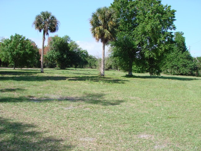
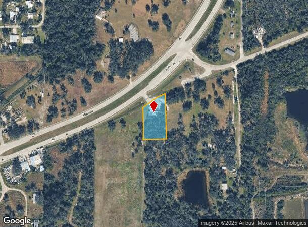
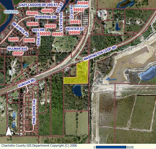
Property Record
4214 Duncan Rd, Punta Gorda, FL 33982
NEARBY LISTINGS FOR SALE OR LEASE
Property Detail
4214 Duncan Rd
402325278001
Acreage
Restaurantbuilding
25 40 23 P-11 1.32 AC. M/L BEG AT INTXN OF S/LY R/W LINE OF HWY 17 WITH W LINE OF SE1/4 OF SE1/4 OF NE 1/4 S 233.26FT E 167.55FT N 303.24 FT TO S R/W LINE HWY 17 SW ALG R/W LINE TO POB 233/593 404/352 551/2143 608/1519 739/1258 999/605 1099/1468
AE
Charlotte
12015C0252G
Florida
2024
1.03 AC
2025
Charlotte County
010200
Southwest Florida
3,447 SF
Punta Gorda, FL
DEMOGRAPHICS near 4214 Duncan Rd
1 Mile
3 Mile
5 Mile
2024 Total Population
670
6,779
22,061
2029 Population
816
8,210
26,652
Pop Growth 2024-2029
+ 21.79%
+ 21.11%
+ 20.81%
Average Age
52
50
50
2024 Total Households
325
3,057
9,898
HH Growth 2024-2029
+ 22.15%
+ 21.26%
+ 21.02%
Median Household Inc
$39,347
$48,954
$48,628
Avg Household Size
2.00
2.20
2.20
2024 Avg HH Vehicles
2.00
2.00
2.00
Median Home Value
$91,726
$228,143
$244,557
Median Year Built
1986
1989
1992
Nearby Places
Map Layers
Map Styles
 Street
 Aerial
- Restaurants
- Banks
- Shops
- Fitness
- Groceries
PUBLIC TRANSPORTATION
AIRPORT
Punta Gorda
DRIVE
WALK
Distance
Punta Gorda
12 min
6.5 mi
Southwest Florida International
DRIVE
WALK
Distance
Southwest Florida International
51 min
40.9 mi
Freight Ports
Port Manatee
DRIVE
WALK
Distance
Port Manatee
89 min
74.7 mi
SALE & LEASE HISTORY
LISTING DATE
SALE/LEASE

Sep 24, 2016
For Sale
Nearby Properties
Address
Land Use
TOTAL SIZE
Lot Size
Zoning
Address
Land Use
TOTAL SIZE
Lot Size
Zoning
66,461 SF
10.86 AC
CG
Address
Land Use
TOTAL SIZE
Lot Size
Zoning
1,556 SF
23.08 AC
CG
Address
Land Use
TOTAL SIZE
Lot Size
Zoning
642 AC
ES
Address
Land Use
TOTAL SIZE
Lot Size
Zoning
31,194 SF
7.93 AC
CG
Address
Land Use
TOTAL SIZE
Lot Size
Zoning
34,854 SF
655 AC
ES
Address
Land Use
TOTAL SIZE
Lot Size
Zoning
8,750 SF
21.19 AC
CG
Address
Land Use
TOTAL SIZE
Lot Size
Zoning
720 SF
314 AC
PD
Address
Land Use
TOTAL SIZE
Lot Size
Zoning
2,400 SF
1.65 AC
IG
Address
Land Use
TOTAL SIZE
Lot Size
Zoning
16,969 SF
81.30 AC
EM
Address
Land Use
TOTAL SIZE
Lot Size
Zoning
18,256 SF
5.20 AC
RE1
Address
Land Use
TOTAL SIZE
Lot Size
Zoning
21,609 SF
20 AC
AG
Address
Land Use
TOTAL SIZE
Lot Size
Zoning
13.53 AC
CG
Address
Land Use
TOTAL SIZE
Lot Size
Zoning
18,144 SF
2.73 AC
IG
Address
Land Use
TOTAL SIZE
Lot Size
Zoning
10 AC
ECAP
Address
Land Use
TOTAL SIZE
Lot Size
Zoning
10 AC
ECAP
Address
Land Use
TOTAL SIZE
Lot Size
Zoning
10 AC
ECAP
Address
Land Use
TOTAL SIZE
Lot Size
Zoning
1,960 SF
2.03 AC
IG
Address
Land Use
TOTAL SIZE
Lot Size
Zoning
249.65 AC
ES
Address
Land Use
TOTAL SIZE
Lot Size
Zoning
1,416 SF
3.85 AC
RMF5
Address
Land Use
TOTAL SIZE
Lot Size
Zoning
8.97 AC
ECAP
Address
Land Use
TOTAL SIZE
Lot Size
Zoning
4,926 SF
8.10 AC
PKR
Address
Land Use
TOTAL SIZE
Lot Size
Zoning
15,000 SF
1.50 AC
IG
Address
Land Use
TOTAL SIZE
Lot Size
Zoning
8,823 SF
73.60 AC
RE1
Address
Land Use
TOTAL SIZE
Lot Size
Zoning
3,280 SF
1.06 AC
CG
Address
Land Use
TOTAL SIZE
Lot Size
Zoning
10,500 SF
0.97 AC
CG
Address
Land Use
TOTAL SIZE
Lot Size
Zoning
12,360 SF
1.59 AC
CG
Address
Land Use
TOTAL SIZE
Lot Size
Zoning
5,400 SF
7.09 AC
CG
Address
Land Use
TOTAL SIZE
Lot Size
Zoning
11,776 SF
0.90 AC
IG
Address
Land Use
TOTAL SIZE
Lot Size
Zoning
6,960 SF
0.86 AC
CG
Address
Land Use
TOTAL SIZE
Lot Size
Zoning
8,500 SF
0.76 AC
IG
The World's #1 Commercial Real Estate Marketplace
Connect with us
© 2025 CoStar Group
The information above has been obtained from sources believed reliable. While we do not doubt its accuracy we have not verified it and make no guarantee, warranty or representation about it. It is your responsibility to independently confirm its accuracy and completeness. Any projections, opinions, assumptions, or estimates used are for example only and do not represent the current or future performance of the property. The value of this transaction to you depends on tax and other factors which should be evaluated by your tax, financial, and legal advisors. You and your advisors should conduct a careful, independent investigation of the property to determine to your satisfaction the suitability of the property for your needs.