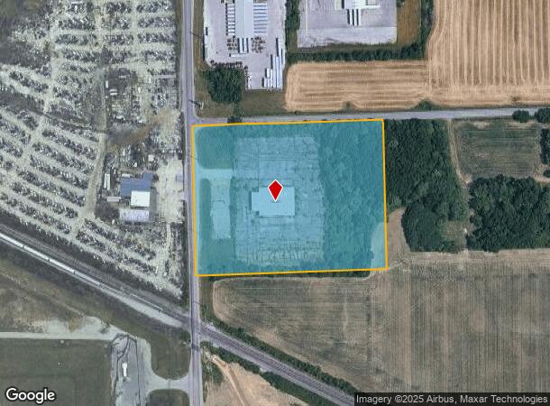
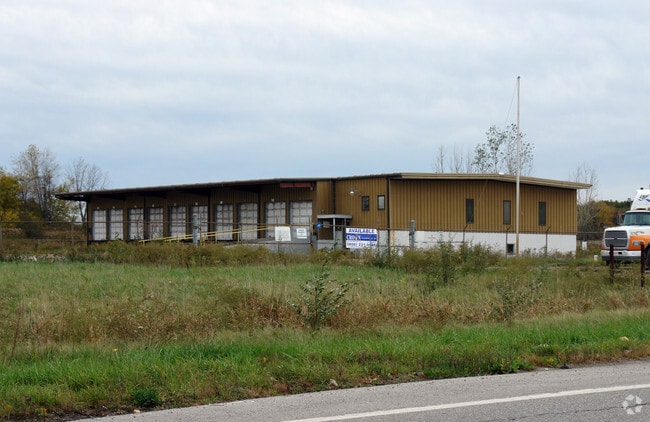
Property Record
4221 S Maplecrest Rd, Fort Wayne, IN 46806

NEARBY LISTINGS FOR SALE OR LEASE
Property Detail
4221 S Maplecrest Rd
02-13-22-100-001.000-041
W 626 OF N 490 FT W1/2 NW1/4 SEC 22
Truckterminal
Allen
X
Indiana
18003C0320G
7.04 AC
2023
New Haven
2024
Fort Wayne
011202
Fort Wayne, IN
10,450 SF
DEMOGRAPHICS near 4221 S Maplecrest Rd
1 Mile
3 Mile
5 Mile
2024 Total Population
1,536
35,227
130,259
2029 Population
1,597
36,833
135,939
Pop Growth 2024-2029
+ 3.97%
+ 4.56%
+ 4.36%
Average Age
39
37
37
2024 Total Households
602
12,990
50,439
HH Growth 2024-2029
+ 4.15%
+ 4.50%
+ 4.38%
Median Household Inc
$56,491
$49,615
$47,512
Avg Household Size
2.50
2.60
2.50
2024 Avg HH Vehicles
2.00
2.00
2.00
Median Home Value
$118,049
$122,610
$131,427
Median Year Built
1960
1969
1964
Nearby Places
Map Layers
Map Styles
 Street
 Aerial
- Restaurants
- Banks
- Shops
- Fitness
- Groceries
PUBLIC TRANSPORTATION
AIRPORT
Fort Wayne International
DRIVE
WALK
Distance
Fort Wayne International
24 min
12.2 mi
SALE & LEASE HISTORY
LISTING DATE
SALE/LEASE

Sep 25, 2016
For Lease
Oct 03, 2022
For Sale
Feb 26, 2025
For Sale
Nearby Properties
Address
Land Use
TOTAL SIZE
Lot Size
Zoning
Address
Land Use
TOTAL SIZE
Lot Size
Zoning
23,326 SF
15.27 AC
Address
Land Use
TOTAL SIZE
Lot Size
Zoning
180,813 SF
24.60 AC
Address
Land Use
TOTAL SIZE
Lot Size
Zoning
149,627 SF
6.53 AC
Address
Land Use
TOTAL SIZE
Lot Size
Zoning
860,503 SF
39.56 AC
Address
Land Use
TOTAL SIZE
Lot Size
Zoning
237,829 SF
49.86 AC
Address
Land Use
TOTAL SIZE
Lot Size
Zoning
398,376 SF
30.66 AC
Address
Land Use
TOTAL SIZE
Lot Size
Zoning
57,892 SF
2.18 AC
Address
Land Use
TOTAL SIZE
Lot Size
Zoning
30,400 SF
13.29 AC
Address
Land Use
TOTAL SIZE
Lot Size
Zoning
27,060 SF
19.83 AC
Address
Land Use
TOTAL SIZE
Lot Size
Zoning
68,547 SF
11.50 AC
Address
Land Use
TOTAL SIZE
Lot Size
Zoning
494,024 SF
35.05 AC
Address
Land Use
TOTAL SIZE
Lot Size
Zoning
403,420 SF
14.46 AC
Address
Land Use
TOTAL SIZE
Lot Size
Zoning
24,950 SF
12.34 AC
Address
Land Use
TOTAL SIZE
Lot Size
Zoning
514,116 SF
41.47 AC
Address
Land Use
TOTAL SIZE
Lot Size
Zoning
68,452 SF
9.95 AC
Address
Land Use
TOTAL SIZE
Lot Size
Zoning
432,400 SF
26.29 AC
Address
Land Use
TOTAL SIZE
Lot Size
Zoning
33,472 SF
3.51 AC
Address
Land Use
TOTAL SIZE
Lot Size
Zoning
29,194 SF
4 AC
Address
Land Use
TOTAL SIZE
Lot Size
Zoning
1,770 SF
33.32 AC
Address
Land Use
TOTAL SIZE
Lot Size
Zoning
160,526 SF
43.37 AC
Address
Land Use
TOTAL SIZE
Lot Size
Zoning
94,280 SF
16.41 AC
Address
Land Use
TOTAL SIZE
Lot Size
Zoning
60,463 SF
4.02 AC
Address
Land Use
TOTAL SIZE
Lot Size
Zoning
379,458 SF
11.43 AC
Address
Land Use
TOTAL SIZE
Lot Size
Zoning
23,268 SF
19.46 AC
Address
Land Use
TOTAL SIZE
Lot Size
Zoning
81,332 SF
5 AC
Address
Land Use
TOTAL SIZE
Lot Size
Zoning
45,472 SF
4.51 AC
Address
Land Use
TOTAL SIZE
Lot Size
Zoning
56,343 SF
5 AC
Address
Land Use
TOTAL SIZE
Lot Size
Zoning
55,541 SF
5.53 AC
Address
Land Use
TOTAL SIZE
Lot Size
Zoning
1,624,941 SF
101.67 AC
Address
Land Use
TOTAL SIZE
Lot Size
Zoning
40,321 SF
5.87 AC
The World's #1 Commercial Real Estate Marketplace
Connect with us
© 2025 CoStar Group
The information above has been obtained from sources believed reliable. While we do not doubt its accuracy we have not verified it and make no guarantee, warranty or representation about it. It is your responsibility to independently confirm its accuracy and completeness. Any projections, opinions, assumptions, or estimates used are for example only and do not represent the current or future performance of the property. The value of this transaction to you depends on tax and other factors which should be evaluated by your tax, financial, and legal advisors. You and your advisors should conduct a careful, independent investigation of the property to determine to your satisfaction the suitability of the property for your needs.