Property Record
4235 Duncan Rd, Punta Gorda, FL 33982
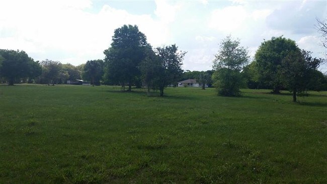

This Property Is For Sale
NEARBY LISTINGS FOR SALE OR LEASE
Property Detail
4235 Duncan Rd
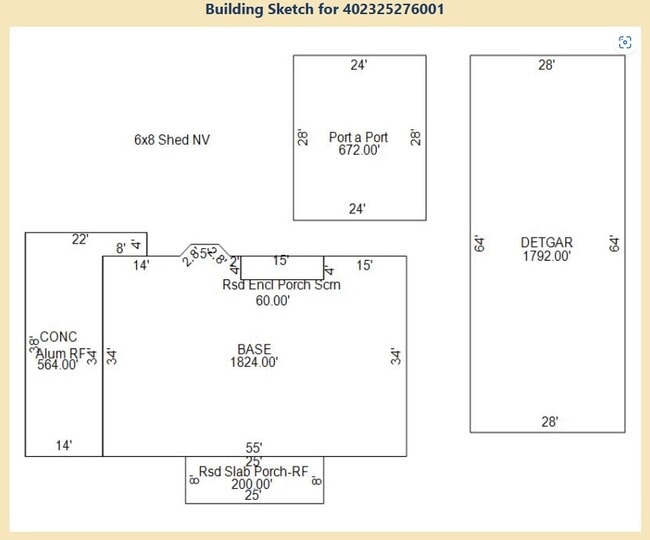
402325276001
Acreage & Unrec
Livestock
25 40 23 P-10 17.98 AC. M/L ALL THAT PART OF SE1/4 OF NE1/4 LYING NW OF US HWY 17 293/320-322 362/545 371/255 463/260 497/596 CA#73-596 498/324 509/547 599/884 616/354 625/2134 626/928 841/2131 ROW1553/826(EASEMENT) FJ1630/1
AE
Charlotte
12015C0252G
Florida
2024
17.98 AC
2025
Charlotte County
010200
Southwest Florida
1,824 SF
Punta Gorda, FL
DEMOGRAPHICS near 4235 Duncan Rd
1 mile
3 mile
5 mile
2024 Total Population
685
7,050
23,239
2029 Population
835
8,534
28,062
Pop Growth 2024-2029
+ 21.90%
+ 21.05%
+ 20.75%
Average Age
52
50
50
2024 Total Households
334
3,178
10,425
HH Growth 2024-2029
+ 22.16%
+ 21.21%
+ 20.98%
Median Household Inc
$38,518
$48,905
$48,731
Avg Household Size
2.00
2.20
2.20
2024 Avg HH Vehicles
2.00
2.00
2.00
Median Home Value
$93,309
$231,418
$245,937
Median Year Built
1986
1989
1992
Nearby Places
Map Layers
Map Styles
 Street
 Aerial
Transit
 Traffic
 Biking
Places
Listings with unknown addresses are not visible on the map
- Restaurants
- Banks
- Shops
- Fitness
- Groceries
PUBLIC TRANSPORTATION
AIRPORT
Punta Gorda
Drive
Walk
Distance
Punta Gorda
12 min
7.0 mi
Freight Ports
Port Manatee
Drive
Walk
Distance
Port Manatee
89 min
75.2 mi
Nearby Properties
Address
Land Use
TOTAL SIZE
Lot Size
Zoning
Address
Land Use
TOTAL SIZE
Lot Size
Zoning
4,715 SF
48.73 AC
MHP
Address
Land Use
TOTAL SIZE
Lot Size
Zoning
66,461 SF
10.86 AC
CG
Address
Land Use
TOTAL SIZE
Lot Size
Zoning
1,556 SF
23.08 AC
CG
Address
Land Use
TOTAL SIZE
Lot Size
Zoning
5,029 SF
9.83 AC
MHP
Address
Land Use
TOTAL SIZE
Lot Size
Zoning
31,194 SF
7.93 AC
CG
Address
Land Use
TOTAL SIZE
Lot Size
Zoning
34,854 SF
655 AC
ES
Address
Land Use
TOTAL SIZE
Lot Size
Zoning
8,750 SF
21.19 AC
CG
Address
Land Use
TOTAL SIZE
Lot Size
Zoning
720 SF
314 AC
PD
Address
Land Use
TOTAL SIZE
Lot Size
Zoning
2,400 SF
1.65 AC
IG
Address
Land Use
TOTAL SIZE
Lot Size
Zoning
16,969 SF
81.30 AC
EM
Address
Land Use
TOTAL SIZE
Lot Size
Zoning
18,256 SF
5.20 AC
RE1
Address
Land Use
TOTAL SIZE
Lot Size
Zoning
1,407 SF
5.61 AC
RE1
Address
Land Use
TOTAL SIZE
Lot Size
Zoning
21,609 SF
20 AC
AG
Address
Land Use
TOTAL SIZE
Lot Size
Zoning
13.53 AC
CG
Address
Land Use
TOTAL SIZE
Lot Size
Zoning
984 SF
1.17 AC
RSF5
Address
Land Use
TOTAL SIZE
Lot Size
Zoning
18,144 SF
2.73 AC
IG
Address
Land Use
TOTAL SIZE
Lot Size
Zoning
4,631 SF
2.31 AC
RSF3.5
Address
Land Use
TOTAL SIZE
Lot Size
Zoning
3,619 SF
1.04 AC
RE1
Address
Land Use
TOTAL SIZE
Lot Size
Zoning
10 AC
ECAP
Address
Land Use
TOTAL SIZE
Lot Size
Zoning
10 AC
ECAP
Address
Land Use
TOTAL SIZE
Lot Size
Zoning
10 AC
ECAP
Address
Land Use
TOTAL SIZE
Lot Size
Zoning
1,960 SF
2.03 AC
IG
Address
Land Use
TOTAL SIZE
Lot Size
Zoning
6,758 SF
2.62 AC
RMF5
Address
Land Use
TOTAL SIZE
Lot Size
Zoning
1,416 SF
3.85 AC
RMF5
Address
Land Use
TOTAL SIZE
Lot Size
Zoning
4,386 SF
2.67 AC
RMF5
Address
Land Use
TOTAL SIZE
Lot Size
Zoning
7,822 SF
16.50 AC
AG
Address
Land Use
TOTAL SIZE
Lot Size
Zoning
3,566 SF
1.17 AC
RE1
Address
Land Use
TOTAL SIZE
Lot Size
Zoning
8.97 AC
ECAP
Address
Land Use
TOTAL SIZE
Lot Size
Zoning
2,308 SF
4.67 AC
RSF3.5
Address
Land Use
TOTAL SIZE
Lot Size
Zoning
6,585 SF
2.27 AC
RSF3.5
The World's #1 Commercial Real Estate Marketplace
Connect with us
© 2026 CoStar Group
The information above has been obtained from sources believed reliable. While we do not doubt its accuracy we have not verified it and make no guarantee, warranty or representation about it. It is your responsibility to independently confirm its accuracy and completeness. Any projections, opinions, assumptions, or estimates used are for example only and do not represent the current or future performance of the property. The value of this transaction to you depends on tax and other factors which should be evaluated by your tax, financial, and legal advisors. You and your advisors should conduct a careful, independent investigation of the property to determine to your satisfaction the suitability of the property for your needs.