Property Record
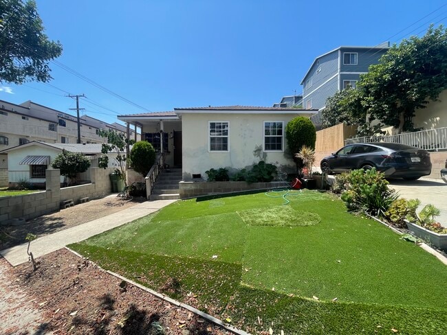
425 N Exton Ave, Inglewood, CA 90302


This Property Is For Sale
NEARBY LISTINGS FOR SALE OR LEASE
Property Detail
425 N Exton Ave
Los Angeles-Long Beach-Glendale, CA
1453
4015-011-017
TRACT # 1453 NW 49 FT MEASURED ON SW LINE OF LOT 612
Quadruplex
Los Angeles
X
California
06037C1776G
612
2024
0.16 AC
2025
Inglewood
600902
Los Angeles
2,944 SF
DEMOGRAPHICS near 425 N Exton Ave
1 Mile
3 Mile
5 Mile
2024 Total Population
38,664
275,422
894,399
2029 Population
38,696
273,658
887,973
Pop Growth 2024-2029
+ 0.08%
(0.64%)
(0.72%)
Average Age
40
41
39
2024 Total Households
14,805
98,877
306,355
HH Growth 2024-2029
+ 0.04%
(0.74%)
(0.83%)
Median Household Inc
$68,318
$75,133
$76,626
Avg Household Size
2.50
2.70
2.80
2024 Avg HH Vehicles
2.00
2.00
2.00
Median Home Value
$787,387
$848,766
$866,433
Median Year Built
1964
1956
1958
Nearby Places
Map Layers
Map Styles
 Street
 Aerial
- Restaurants
- Banks
- Shops
- Fitness
- Groceries
PUBLIC TRANSPORTATION
AIRPORT
Los Angeles International
DRIVE
WALK
Distance
Los Angeles International
11 min
5.0 mi
Bob Hope
DRIVE
WALK
Distance
Bob Hope
38 min
18.1 mi
Long Beach (Daugherty Field)
DRIVE
WALK
Distance
Long Beach (Daugherty Field)
29 min
19.7 mi
Freight Ports
Port of Long Beach
DRIVE
WALK
Distance
Port of Long Beach
33 min
21.7 mi
Nearby Properties
Address
Land Use
TOTAL SIZE
Lot Size
Zoning
Address
Land Use
TOTAL SIZE
Lot Size
Zoning
2,531,696 SF
79.60 AC
INCR*
Address
Land Use
TOTAL SIZE
Lot Size
Zoning
Address
Land Use
TOTAL SIZE
Lot Size
Zoning
Address
Land Use
TOTAL SIZE
Lot Size
Zoning
Address
Land Use
TOTAL SIZE
Lot Size
Zoning
Address
Land Use
TOTAL SIZE
Lot Size
Zoning
402,060 SF
3.58 AC
LAC2
Address
Land Use
TOTAL SIZE
Lot Size
Zoning
670,596 SF
11.60 AC
LAR4
Address
Land Use
TOTAL SIZE
Lot Size
Zoning
724,715 SF
5.76 AC
INCR*
Address
Land Use
TOTAL SIZE
Lot Size
Zoning
297,937 SF
1.59 AC
CCC3*
Address
Land Use
TOTAL SIZE
Lot Size
Zoning
283,733 SF
2.82 AC
CCC3
Address
Land Use
TOTAL SIZE
Lot Size
Zoning
329,810 SF
2.21 AC
LAC2
Address
Land Use
TOTAL SIZE
Lot Size
Zoning
622,357 SF
3.42 AC
LAC2
Address
Land Use
TOTAL SIZE
Lot Size
Zoning
632,476 SF
10.56 AC
LAC2
Address
Land Use
TOTAL SIZE
Lot Size
Zoning
329,322 SF
1.28 AC
LAC2
Address
Land Use
TOTAL SIZE
Lot Size
Zoning
784,680 SF
18.28 AC
LAM1
Address
Land Use
TOTAL SIZE
Lot Size
Zoning
530,660 SF
20.58 AC
CCC3*
Address
Land Use
TOTAL SIZE
Lot Size
Zoning
514,125 SF
3.11 AC
LAC2
Address
Land Use
TOTAL SIZE
Lot Size
Zoning
249,132 SF
2.31 AC
CCC3*
Address
Land Use
TOTAL SIZE
Lot Size
Zoning
304,968 SF
3.07 AC
CCC3*
Address
Land Use
TOTAL SIZE
Lot Size
Zoning
361,000 SF
3.86 AC
LAC2
Address
Land Use
TOTAL SIZE
Lot Size
Zoning
859,786 SF
4.82 AC
LAC2
Address
Land Use
TOTAL SIZE
Lot Size
Zoning
166,686 SF
1.23 AC
LAC4
Address
Land Use
TOTAL SIZE
Lot Size
Zoning
801,040 SF
5.69 AC
LAC2
Address
Land Use
TOTAL SIZE
Lot Size
Zoning
221,067 SF
1.65 AC
LAC2
Address
Land Use
TOTAL SIZE
Lot Size
Zoning
1,359,630 SF
29 AC
INCR*
Address
Land Use
TOTAL SIZE
Lot Size
Zoning
255,284 SF
2.61 AC
CCC3*
Address
Land Use
TOTAL SIZE
Lot Size
Zoning
102,877 SF
8.69 AC
LAC2
Address
Land Use
TOTAL SIZE
Lot Size
Zoning
343,879 SF
4.26 AC
LAC2
Address
Land Use
TOTAL SIZE
Lot Size
Zoning
286,309 SF
2.62 AC
LAC2
Address
Land Use
TOTAL SIZE
Lot Size
Zoning
242,570 SF
1.83 AC
LAC2
The World's #1 Commercial Real Estate Marketplace
Connect with us
© 2025 CoStar Group
The information above has been obtained from sources believed reliable. While we do not doubt its accuracy we have not verified it and make no guarantee, warranty or representation about it. It is your responsibility to independently confirm its accuracy and completeness. Any projections, opinions, assumptions, or estimates used are for example only and do not represent the current or future performance of the property. The value of this transaction to you depends on tax and other factors which should be evaluated by your tax, financial, and legal advisors. You and your advisors should conduct a careful, independent investigation of the property to determine to your satisfaction the suitability of the property for your needs.