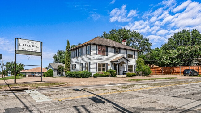
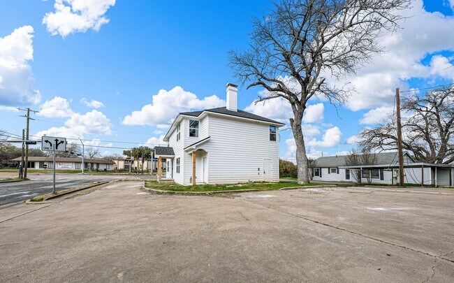
Property Record
427 N 38Th St, Waco, TX 76710

NEARBY LISTINGS FOR SALE OR LEASE
Property Detail
427 N 38Th St
Waco, TX
Castle Hts
48-008000-011100-3
CASTLE HTS LOT 1 BLOCK H ACRES .2025
Commercialnec
Mclennan
X
Texas
48309C0366D
1
2024
0.20 AC
2025
Waco & Killeen
002498
Other Market Areas
2,694 SF
DEMOGRAPHICS near 427 N 38Th St
1 Mile
3 Mile
5 Mile
2024 Total Population
9,939
93,944
143,620
2029 Population
10,580
99,996
152,738
Pop Growth 2024-2029
+ 6.45%
+ 6.44%
+ 6.35%
Average Age
37
35
36
2024 Total Households
3,837
35,302
54,489
HH Growth 2024-2029
+ 6.67%
+ 6.85%
+ 6.68%
Median Household Inc
$46,713
$43,983
$47,029
Avg Household Size
2.50
2.50
2.40
2024 Avg HH Vehicles
2.00
2.00
2.00
Median Home Value
$145,421
$135,568
$166,033
Median Year Built
1958
1969
1974
Nearby Places
Map Layers
Map Styles
 Street
 Aerial
- Restaurants
- Banks
- Shops
- Fitness
- Groceries
PUBLIC TRANSPORTATION
AIRPORT
Waco Regional
DRIVE
WALK
Distance
Waco Regional
19 min
9.5 mi
Freight Ports
Port of Houston
DRIVE
WALK
Distance
Port of Houston
219 min
190.9 mi
SALE & LEASE HISTORY
LISTING DATE
SALE/LEASE

Jul 02, 2021
For Sale
Apr 25, 2025
For Sale
Nearby Properties
Address
Land Use
TOTAL SIZE
Lot Size
Zoning
Address
Land Use
TOTAL SIZE
Lot Size
Zoning
Address
Land Use
TOTAL SIZE
Lot Size
Zoning
347,331 SF
50.71 AC
C2
Address
Land Use
TOTAL SIZE
Lot Size
Zoning
693,933 SF
57.98 AC
M2
Address
Land Use
TOTAL SIZE
Lot Size
Zoning
560,620 SF
3.70 AC
O2
Address
Land Use
TOTAL SIZE
Lot Size
Zoning
576,501 SF
4.21 AC
Address
Land Use
TOTAL SIZE
Lot Size
Zoning
452,498 SF
39.43 AC
C-2
Address
Land Use
TOTAL SIZE
Lot Size
Zoning
394,674 SF
21.31 AC
O2
Address
Land Use
TOTAL SIZE
Lot Size
Zoning
285,829 SF
17.35 AC
Address
Land Use
TOTAL SIZE
Lot Size
Zoning
255,615 SF
18.58 AC
Address
Land Use
TOTAL SIZE
Lot Size
Zoning
248,132 SF
11.51 AC
R3C
Address
Land Use
TOTAL SIZE
Lot Size
Zoning
289,245 SF
18.02 AC
C1
Address
Land Use
TOTAL SIZE
Lot Size
Zoning
263,557 SF
12 AC
Address
Land Use
TOTAL SIZE
Lot Size
Zoning
291,167 SF
13.61 AC
R
Address
Land Use
TOTAL SIZE
Lot Size
Zoning
399,747 SF
2.86 AC
C-3,C
Address
Land Use
TOTAL SIZE
Lot Size
Zoning
106,633 SF
1.98 AC
C2
Address
Land Use
TOTAL SIZE
Lot Size
Zoning
462,987 SF
36.18 AC
C-3
Address
Land Use
TOTAL SIZE
Lot Size
Zoning
16,678 SF
19.91 AC
C3
Address
Land Use
TOTAL SIZE
Lot Size
Zoning
69,809 SF
8.12 AC
2007 TIF
Address
Land Use
TOTAL SIZE
Lot Size
Zoning
405,640 SF
64.46 AC
Address
Land Use
TOTAL SIZE
Lot Size
Zoning
219,869 SF
11.13 AC
C2
Address
Land Use
TOTAL SIZE
Lot Size
Zoning
231,717 SF
21.97 AC
O2
Address
Land Use
TOTAL SIZE
Lot Size
Zoning
126,592 SF
5.05 AC
2007 TIF
Address
Land Use
TOTAL SIZE
Lot Size
Zoning
188,746 SF
1.14 AC
O2
Address
Land Use
TOTAL SIZE
Lot Size
Zoning
188,465 SF
5.85 AC
2007 TIF
Address
Land Use
TOTAL SIZE
Lot Size
Zoning
342,646 SF
63.20 AC
Address
Land Use
TOTAL SIZE
Lot Size
Zoning
Address
Land Use
TOTAL SIZE
Lot Size
Zoning
10,334 SF
29.45 AC
R1B
Address
Land Use
TOTAL SIZE
Lot Size
Zoning
98,592 SF
15.16 AC
Address
Land Use
TOTAL SIZE
Lot Size
Zoning
107,925 SF
2.20 AC
2007TIF
Address
Land Use
TOTAL SIZE
Lot Size
Zoning
27,245 SF
130.84 AC
R1B
The World's #1 Commercial Real Estate Marketplace
Connect with us
© 2025 CoStar Group
The information above has been obtained from sources believed reliable. While we do not doubt its accuracy we have not verified it and make no guarantee, warranty or representation about it. It is your responsibility to independently confirm its accuracy and completeness. Any projections, opinions, assumptions, or estimates used are for example only and do not represent the current or future performance of the property. The value of this transaction to you depends on tax and other factors which should be evaluated by your tax, financial, and legal advisors. You and your advisors should conduct a careful, independent investigation of the property to determine to your satisfaction the suitability of the property for your needs.