Property Record
429 Washington St, Dayton, OH 45402


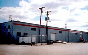
Property Detail
429 Washington St
Dayton, OH
11805-6-7 13130 PTS ETC 17-3-52,55,56,57 17-4-1,2,43,45,96 TO 98
R72-01703-0051
Montgomery
Warehouse
Ohio
C and X Area of minimal flood hazard, usually depicted on FIRMs as above the 500-year flood level.
51
2024
1.28 AC
2025
Downtown Dayton
003404
Cincinnati/Dayton
58,772 SF
NEARBY LISTINGS FOR SALE OR LEASE
DEMOGRAPHICS near 429 Washington St
1 mile
3 mile
5 mile
2024 Total Population
8,255
112,964
234,357
2029 Population
8,506
117,505
239,101
Pop Growth 2024-2029
+ 3.04%
+ 4.02%
+ 2.02%
Average Age
40
37
38
2024 Total Households
4,474
46,529
100,131
HH Growth 2024-2029
+ 3.00%
+ 4.19%
+ 2.03%
Median Household Inc
$40,172
$44,813
$49,281
Avg Household Size
1.60
2.20
2.20
2024 Avg HH Vehicles
1.00
1.00
1.00
Median Home Value
$184,629
$97,999
$125,604
Median Year Built
1955
1948
1953
Nearby Places
Map Layers
Map Styles
 Street
 Aerial
Transit
 Traffic
 Biking
Places
Listings with unknown addresses are not visible on the map
- Restaurants
- Banks
- Shops
- Fitness
- Groceries
PUBLIC TRANSPORTATION
AIRPORT
James M Cox Dayton International
Drive
Walk
Distance
James M Cox Dayton International
23 min
13.8 mi
Freight Ports
Port of Toledo
Drive
Walk
Distance
Port of Toledo
179 min
154.0 mi
Nearby Properties
Address
Land Use
TOTAL SIZE
Lot Size
Zoning
Address
Land Use
TOTAL SIZE
Lot Size
Zoning
1,570,433 SF
13.34 AC
Address
Land Use
TOTAL SIZE
Lot Size
Zoning
154,360 SF
19.35 AC
Address
Land Use
TOTAL SIZE
Lot Size
Zoning
634,753 SF
54 AC
Address
Land Use
TOTAL SIZE
Lot Size
Zoning
127,232 SF
7.96 AC
Address
Land Use
TOTAL SIZE
Lot Size
Zoning
11.64 AC
Address
Land Use
TOTAL SIZE
Lot Size
Zoning
29,760 SF
5.13 AC
Address
Land Use
TOTAL SIZE
Lot Size
Zoning
767,771 SF
1.32 AC
Address
Land Use
TOTAL SIZE
Lot Size
Zoning
17,478 SF
417.01 AC
Address
Land Use
TOTAL SIZE
Lot Size
Zoning
188,584 SF
2.83 AC
Address
Land Use
TOTAL SIZE
Lot Size
Zoning
1.95 AC
Address
Land Use
TOTAL SIZE
Lot Size
Zoning
23,031 SF
63.14 AC
Address
Land Use
TOTAL SIZE
Lot Size
Zoning
5.42 AC
Address
Land Use
TOTAL SIZE
Lot Size
Zoning
5.41 AC
Address
Land Use
TOTAL SIZE
Lot Size
Zoning
23.35 AC
Address
Land Use
TOTAL SIZE
Lot Size
Zoning
375,053 SF
7.27 AC
Address
Land Use
TOTAL SIZE
Lot Size
Zoning
761,679 SF
5.09 AC
Address
Land Use
TOTAL SIZE
Lot Size
Zoning
222,197 SF
1.80 AC
Address
Land Use
TOTAL SIZE
Lot Size
Zoning
11.83 AC
Address
Land Use
TOTAL SIZE
Lot Size
Zoning
200,150 SF
1.81 AC
Address
Land Use
TOTAL SIZE
Lot Size
Zoning
3.76 AC
Address
Land Use
TOTAL SIZE
Lot Size
Zoning
255,494 SF
4.64 AC
Address
Land Use
TOTAL SIZE
Lot Size
Zoning
45,583 SF
4.91 AC
Address
Land Use
TOTAL SIZE
Lot Size
Zoning
128,859 SF
5.31 AC
Address
Land Use
TOTAL SIZE
Lot Size
Zoning
4.86 AC
Address
Land Use
TOTAL SIZE
Lot Size
Zoning
158,144 SF
4.16 AC
Address
Land Use
TOTAL SIZE
Lot Size
Zoning
296,568 SF
3.60 AC
Address
Land Use
TOTAL SIZE
Lot Size
Zoning
268,166 SF
2.12 AC
Address
Land Use
TOTAL SIZE
Lot Size
Zoning
41.38 AC
Address
Land Use
TOTAL SIZE
Lot Size
Zoning
0.74 AC
Address
Land Use
TOTAL SIZE
Lot Size
Zoning
357,800 SF
1.22 AC
The World's #1 Commercial Real Estate Marketplace
Connect with us
© 2026 CoStar Group
The information above has been obtained from sources believed reliable. While we do not doubt its accuracy we have not verified it and make no guarantee, warranty or representation about it. It is your responsibility to independently confirm its accuracy and completeness. Any projections, opinions, assumptions, or estimates used are for example only and do not represent the current or future performance of the property. The value of this transaction to you depends on tax and other factors which should be evaluated by your tax, financial, and legal advisors. You and your advisors should conduct a careful, independent investigation of the property to determine to your satisfaction the suitability of the property for your needs.