Property Record
4298 S Parker Rd, Aurora, CO 80014
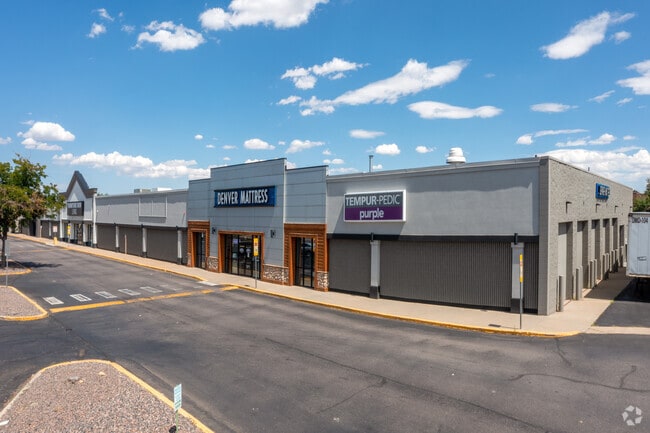

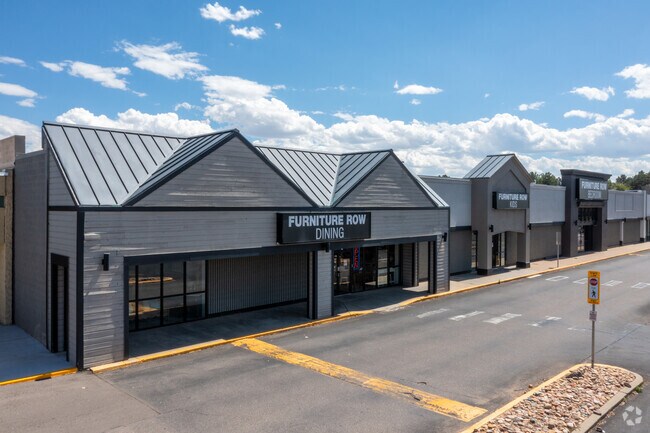
Property Detail
4298 S Parker Rd
Denver-Aurora-Centennial, CO
SUBDIVISIONCD 021191 SUBDIVISIONNAME EAST BANK MALL SUB 2ND FLG BLOCK 001 LOT 001 LOT 1 BLK 1 EAST BANK MALL SUB 2ND FLG EX THAT PART DESC ON REC #E3060205
2073-06-3-60-002
ARAPAHOE
Storebuilding
Colorado
2021
001,1
2025
7.64 AC
083900
Aurora
108,082 SF
Denver
NEARBY LISTINGS FOR SALE OR LEASE
DEMOGRAPHICS near 4298 S Parker Rd
1 mile
3 mile
5 mile
2025 Total Population
12,451
117,617
378,547
2030 Population
12,547
118,938
383,980
Pop Growth 2025-2030
+ 0.77%
+ 1.12%
+ 1.44%
Average Age
41
41
39
2025 Total Households
5,370
46,425
150,210
HH Growth 2025-2030
+ 0.78%
+ 1.24%
+ 1.63%
Median Household Inc
$87,611
$89,427
$92,463
Avg Household Size
2.30
2.50
2.40
2025 Avg HH Vehicles
2.00
2.00
2.00
Median Home Value
$473,983
$487,753
$518,094
Median Year Built
1986
1982
1986
Nearby Places
Map Layers
Map Styles
 Street
 Aerial
Layers
 Traffic
 Biking
Places
Listings with unknown addresses are not visible on the map
- Restaurants
- Banks
- Shops
- Fitness
- Groceries
PUBLIC TRANSPORTATION
AIRPORT
Denver International
Drive
Walk
Distance
Denver International
30 min
23.3 mi
Freight Ports
Tulsa Port Of Catoosa
Drive
Walk
Distance
Tulsa Port Of Catoosa
726 min
706.0 mi
Nearby Properties
Address
Land Use
TOTAL SIZE
Lot Size
Zoning
Address
Land Use
TOTAL SIZE
Lot Size
Zoning
234,214 SF
5.23 AC
Address
Land Use
TOTAL SIZE
Lot Size
Zoning
525,600 SF
57.90 AC
Address
Land Use
TOTAL SIZE
Lot Size
Zoning
476,186 SF
42.62 AC
Address
Land Use
TOTAL SIZE
Lot Size
Zoning
50,106 SF
1.67 AC
RB1
Address
Land Use
TOTAL SIZE
Lot Size
Zoning
613,600 SF
29.40 AC
R-3
Address
Land Use
TOTAL SIZE
Lot Size
Zoning
103,811 SF
6.36 AC
RPD
Address
Land Use
TOTAL SIZE
Lot Size
Zoning
130,531 SF
3.41 AC
Address
Land Use
TOTAL SIZE
Lot Size
Zoning
217,273 SF
18.28 AC
Address
Land Use
TOTAL SIZE
Lot Size
Zoning
138,750 SF
12.17 AC
OS-A
Address
Land Use
TOTAL SIZE
Lot Size
Zoning
383,436 SF
9.77 AC
Address
Land Use
TOTAL SIZE
Lot Size
Zoning
168,500 SF
24.03 AC
Address
Land Use
TOTAL SIZE
Lot Size
Zoning
122,965 SF
12.30 AC
RPD
Address
Land Use
TOTAL SIZE
Lot Size
Zoning
368,462 SF
11.68 AC
RZMF
Address
Land Use
TOTAL SIZE
Lot Size
Zoning
462,048 SF
5.34 AC
RB3
Address
Land Use
TOTAL SIZE
Lot Size
Zoning
105,809 SF
48.79 AC
Address
Land Use
TOTAL SIZE
Lot Size
Zoning
119,074 SF
9.38 AC
AMU
Address
Land Use
TOTAL SIZE
Lot Size
Zoning
353,956 SF
8.28 AC
R-3
Address
Land Use
TOTAL SIZE
Lot Size
Zoning
314,961 SF
10.56 AC
R-3
Address
Land Use
TOTAL SIZE
Lot Size
Zoning
112,612 SF
7.44 AC
AMU
Address
Land Use
TOTAL SIZE
Lot Size
Zoning
192,915 SF
7.16 AC
Address
Land Use
TOTAL SIZE
Lot Size
Zoning
26,880 SF
20.44 AC
Address
Land Use
TOTAL SIZE
Lot Size
Zoning
187,528 SF
6.15 AC
Address
Land Use
TOTAL SIZE
Lot Size
Zoning
220,184 SF
20.45 AC
RPD
Address
Land Use
TOTAL SIZE
Lot Size
Zoning
208,095 SF
14.52 AC
Address
Land Use
TOTAL SIZE
Lot Size
Zoning
172,715 SF
4.23 AC
Address
Land Use
TOTAL SIZE
Lot Size
Zoning
208,310 SF
8.72 AC
Address
Land Use
TOTAL SIZE
Lot Size
Zoning
96,480 SF
9.51 AC
PUD
Address
Land Use
TOTAL SIZE
Lot Size
Zoning
344,071 SF
17.10 AC
Address
Land Use
TOTAL SIZE
Lot Size
Zoning
307,372 SF
7.15 AC
Address
Land Use
TOTAL SIZE
Lot Size
Zoning
114,838 SF
12.50 AC
The World's #1 Commercial Real Estate Marketplace
Connect with us
© 2026 CoStar Group
The information above has been obtained from sources believed reliable. While we do not doubt its accuracy we have not verified it and make no guarantee, warranty or representation about it. It is your responsibility to independently confirm its accuracy and completeness. Any projections, opinions, assumptions, or estimates used are for example only and do not represent the current or future performance of the property. The value of this transaction to you depends on tax and other factors which should be evaluated by your tax, financial, and legal advisors. You and your advisors should conduct a careful, independent investigation of the property to determine to your satisfaction the suitability of the property for your needs.