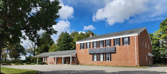
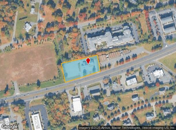
Property Record
430 State Route 10, Randolph, NJ 07869

NEARBY LISTINGS FOR SALE OR LEASE
Property Detail
430 State Route 10
Newark, NJ
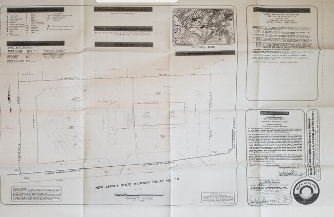
ADDITIONAL LOTS: B88 L19-A/FACILITY NAME: TAX CT JDGMT 1993
32-00111-0000-00024
Morris
Commercialnec
New Jersey
2024
24
2025
1.66 AC
045603
Western Morris
12,290 SF
Northern New Jersey
DEMOGRAPHICS near 430 State Route 10
1 mile
3 mile
5 mile
2024 Total Population
8,773
62,365
130,055
2029 Population
8,684
62,133
129,819
Pop Growth 2024-2029
(1.01%)
(0.37%)
(0.18%)
Average Age
39
40
42
2024 Total Households
3,295
21,343
47,215
HH Growth 2024-2029
(1.27%)
(0.45%)
(0.20%)
Median Household Inc
$90,259
$101,534
$116,959
Avg Household Size
2.60
2.80
2.70
2024 Avg HH Vehicles
2.00
2.00
2.00
Median Home Value
$434,435
$432,451
$448,317
Median Year Built
1972
1970
1970
Nearby Places
Map Layers
Map Styles
 Street
 Aerial
Transit
 Traffic
 Biking
Places
Listings with unknown addresses are not visible on the map
- Restaurants
- Banks
- Shops
- Fitness
- Groceries
PUBLIC TRANSPORTATION
COMMUTER RAIL
Dover (Montclair-Boonton Line - NJ Transit Commuter Rail (NJ Transit), Morris & Essex Morristown Line - NJ Transit Commuter Rail (NJ Transit))
Drive
Walk
Distance
Dover (Montclair-Boonton Line - NJ Transit Commuter Rail (NJ Transit), Morris & Essex Morristown Line - NJ Transit Commuter Rail (NJ Transit))
5 min
2.5 mi
Mount Tabor (Morris & Essex Morristown Line - NJ Transit Commuter Rail (NJ Transit))
Drive
Walk
Distance
Mount Tabor (Morris & Essex Morristown Line - NJ Transit Commuter Rail (NJ Transit))
12 min
6.2 mi
AIRPORT
Newark Liberty International
Drive
Walk
Distance
Newark Liberty International
39 min
30.6 mi
Freight Ports
Maher Terminal
Drive
Walk
Distance
Maher Terminal
43 min
31.2 mi
SALE & LEASE HISTORY
LISTING DATE
SALE/LEASE

Sep 25, 2024
For Sale
Nearby Properties
Address
Land Use
TOTAL SIZE
Lot Size
Zoning
Address
Land Use
TOTAL SIZE
Lot Size
Zoning
222.79 AC
R1
Address
Land Use
TOTAL SIZE
Lot Size
Zoning
401,303 SF
59.54 AC
R-B
Address
Land Use
TOTAL SIZE
Lot Size
Zoning
64.62 AC
R3
Address
Land Use
TOTAL SIZE
Lot Size
Zoning
30.13 AC
I-3
Address
Land Use
TOTAL SIZE
Lot Size
Zoning
95,368 SF
33.81 AC
RMF8
Address
Land Use
TOTAL SIZE
Lot Size
Zoning
28.62 AC
OSGU
Address
Land Use
TOTAL SIZE
Lot Size
Zoning
197,412 SF
28.60 AC
OSGU
Address
Land Use
TOTAL SIZE
Lot Size
Zoning
23.66 AC
I1
Address
Land Use
TOTAL SIZE
Lot Size
Zoning
20.05 AC
R-1
Address
Land Use
TOTAL SIZE
Lot Size
Zoning
97,716 SF
60.89 AC
0-2
Address
Land Use
TOTAL SIZE
Lot Size
Zoning
26,967 SF
14.06 AC
OB-4
Address
Land Use
TOTAL SIZE
Lot Size
Zoning
Address
Land Use
TOTAL SIZE
Lot Size
Zoning
156,564 SF
19.66 AC
B-2
Address
Land Use
TOTAL SIZE
Lot Size
Zoning
44,600 SF
18.62 AC
R-B
Address
Land Use
TOTAL SIZE
Lot Size
Zoning
195,773 SF
43.54 AC
R-4
Address
Land Use
TOTAL SIZE
Lot Size
Zoning
18.35 AC
RMF8
Address
Land Use
TOTAL SIZE
Lot Size
Zoning
180,636 SF
65.98 AC
I
Address
Land Use
TOTAL SIZE
Lot Size
Zoning
Address
Land Use
TOTAL SIZE
Lot Size
Zoning
19.47 AC
R-4
Address
Land Use
TOTAL SIZE
Lot Size
Zoning
8.08 AC
I-1
Address
Land Use
TOTAL SIZE
Lot Size
Zoning
13.53 AC
R10
Address
Land Use
TOTAL SIZE
Lot Size
Zoning
25.95 AC
I-1
Address
Land Use
TOTAL SIZE
Lot Size
Zoning
38.15 AC
R-1
Address
Land Use
TOTAL SIZE
Lot Size
Zoning
199,694 SF
29.23 AC
B-3
Address
Land Use
TOTAL SIZE
Lot Size
Zoning
16.21 AC
R-4
Address
Land Use
TOTAL SIZE
Lot Size
Zoning
149,815 SF
31.70 AC
Address
Land Use
TOTAL SIZE
Lot Size
Zoning
97,350 SF
8.28 AC
R-B
Address
Land Use
TOTAL SIZE
Lot Size
Zoning
42.43 AC
R-5
Address
Land Use
TOTAL SIZE
Lot Size
Zoning
7.77 AC
RMF
Address
Land Use
TOTAL SIZE
Lot Size
Zoning
9 AC
B-2A
The World's #1 Commercial Real Estate Marketplace
Connect with us
© 2026 CoStar Group
The information above has been obtained from sources believed reliable. While we do not doubt its accuracy we have not verified it and make no guarantee, warranty or representation about it. It is your responsibility to independently confirm its accuracy and completeness. Any projections, opinions, assumptions, or estimates used are for example only and do not represent the current or future performance of the property. The value of this transaction to you depends on tax and other factors which should be evaluated by your tax, financial, and legal advisors. You and your advisors should conduct a careful, independent investigation of the property to determine to your satisfaction the suitability of the property for your needs.