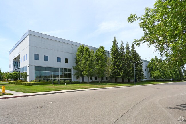
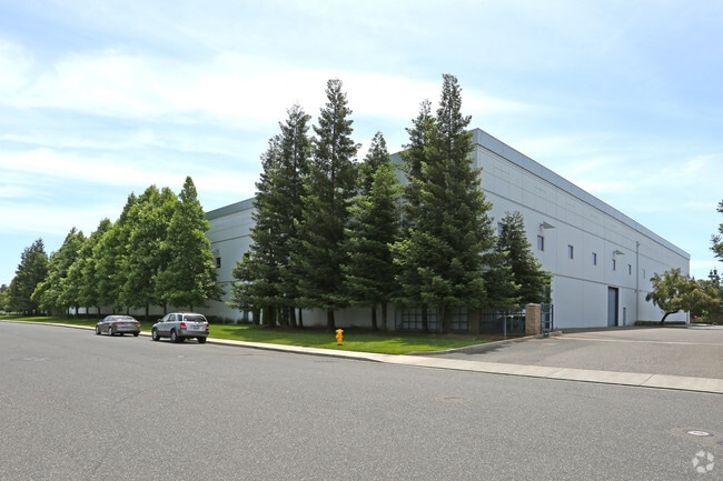
Property Record
4300 Spyres Way, Modesto, CA 95356

Save to a Folder
{{folder.Name}}
{{folder.ListingIds.length}} Properties
{{folder.ListingIds.length}} Property
Create a New Folder
Property Detail
4300 Spyres Way
046-04-64
0
Warehouse
Stanislaus
PI
California
B and X Area of moderate flood hazard, usually the area between the limits of the 100-year and 500-year floods.
4.65 AC
2025
Modesto
2025
Stockton/Modesto
000506
Modesto, CA
91,945 SF
NEARBY LISTINGS FOR SALE OR LEASE
DEMOGRAPHICS near 4300 Spyres Way
1 mile
3 mile
5 mile
2025 Total Population
10,287
102,506
222,323
2030 Population
10,386
103,405
224,004
Pop Growth 2025-2030
+ 0.96%
+ 0.88%
+ 0.76%
Average Age
40
39
39
2025 Total Households
3,858
36,104
76,051
HH Growth 2025-2030
+ 0.88%
+ 0.86%
+ 0.75%
Median Household Inc
$74,350
$85,109
$86,548
Avg Household Size
2.60
2.80
2.80
2025 Avg HH Vehicles
2.00
2.00
2.00
Median Home Value
$463,214
$469,582
$464,669
Median Year Built
1978
1976
1978
Nearby Places
Map Layers
Map Styles
 Street
 Aerial
Layers
 Traffic
 Biking
Places
Listings with unknown addresses are not visible on the map
- Restaurants
- Banks
- Shops
- Fitness
- Groceries
PUBLIC TRANSPORTATION
AIRPORT
Stockton Metro
Drive
Walk
Distance
Stockton Metro
35 min
23.1 mi
Freight Ports
Port of Stockton
Drive
Walk
Distance
Port of Stockton
44 min
31.5 mi
Nearby Properties
Address
Land Use
TOTAL SIZE
Lot Size
Zoning
Address
Land Use
TOTAL SIZE
Lot Size
Zoning
640,835 SF
47.18 AC
PC
Address
Land Use
TOTAL SIZE
Lot Size
Zoning
766,000 SF
22.69 AC
MODPD
Address
Land Use
TOTAL SIZE
Lot Size
Zoning
450,277 SF
15.29 AC
Address
Land Use
TOTAL SIZE
Lot Size
Zoning
9.25 AC
MODSP
Address
Land Use
TOTAL SIZE
Lot Size
Zoning
20.31 AC
COUPD
Address
Land Use
TOTAL SIZE
Lot Size
Zoning
175,804 SF
13.79 AC
Address
Land Use
TOTAL SIZE
Lot Size
Zoning
189,239 SF
8.75 AC
PD
Address
Land Use
TOTAL SIZE
Lot Size
Zoning
131,958 SF
8.11 AC
Address
Land Use
TOTAL SIZE
Lot Size
Zoning
127,142 SF
3.89 AC
MODSP
Address
Land Use
TOTAL SIZE
Lot Size
Zoning
65,294 SF
4.20 AC
Address
Land Use
TOTAL SIZE
Lot Size
Zoning
156,854 SF
12.20 AC
PC
Address
Land Use
TOTAL SIZE
Lot Size
Zoning
120,383 SF
5.52 AC
MODCM
Address
Land Use
TOTAL SIZE
Lot Size
Zoning
15.68 AC
RIVPD
Address
Land Use
TOTAL SIZE
Lot Size
Zoning
79,458 SF
5.32 AC
Address
Land Use
TOTAL SIZE
Lot Size
Zoning
280,223 SF
23.52 AC
MODC2
Address
Land Use
TOTAL SIZE
Lot Size
Zoning
164,473 SF
3.50 AC
MODSP
Address
Land Use
TOTAL SIZE
Lot Size
Zoning
120,160 SF
6 AC
MODPD
Address
Land Use
TOTAL SIZE
Lot Size
Zoning
110,684 SF
5.03 AC
Address
Land Use
TOTAL SIZE
Lot Size
Zoning
123,575 SF
10 AC
PC
Address
Land Use
TOTAL SIZE
Lot Size
Zoning
119,046 SF
8.94 AC
Address
Land Use
TOTAL SIZE
Lot Size
Zoning
60,156 SF
16.20 AC
Address
Land Use
TOTAL SIZE
Lot Size
Zoning
45,916 SF
4.69 AC
MODPO
Address
Land Use
TOTAL SIZE
Lot Size
Zoning
62,280 SF
1.95 AC
Address
Land Use
TOTAL SIZE
Lot Size
Zoning
72,338 SF
5.98 AC
RIVC1
Address
Land Use
TOTAL SIZE
Lot Size
Zoning
188,676 SF
13.27 AC
Address
Land Use
TOTAL SIZE
Lot Size
Zoning
88,224 SF
5.13 AC
PD
Address
Land Use
TOTAL SIZE
Lot Size
Zoning
82,997 SF
4.49 AC
Address
Land Use
TOTAL SIZE
Lot Size
Zoning
80,987 SF
4.33 AC
PD
Address
Land Use
TOTAL SIZE
Lot Size
Zoning
137,582 SF
19.21 AC
MODSP
Address
Land Use
TOTAL SIZE
Lot Size
Zoning
117,526 SF
5.56 AC
The World's #1 Commercial Real Estate Marketplace
Connect with us
© 2026 CoStar Group
The information above has been obtained from sources believed reliable. While we do not doubt its accuracy we have not verified it and make no guarantee, warranty or representation about it. It is your responsibility to independently confirm its accuracy and completeness. Any projections, opinions, assumptions, or estimates used are for example only and do not represent the current or future performance of the property. The value of this transaction to you depends on tax and other factors which should be evaluated by your tax, financial, and legal advisors. You and your advisors should conduct a careful, independent investigation of the property to determine to your satisfaction the suitability of the property for your needs.