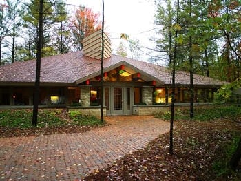
Property Record
4300 W Sugnet Rd, Midland, MI 48640
NEARBY LISTINGS FOR SALE OR LEASE
Property Detail
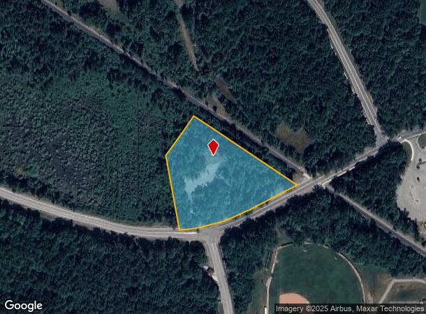
4300 W Sugnet Rd
14-07-70-700
BEG AT THE INTRS OF SW RAIL TRAIL ROW AND N ROW LN OF SUGNET RD, TH N 56D 31M 02S W 505 FT, TH S 35D 50M 35S W 195 FT, TH S 10D 03M 23S E 310 FT TO N LN OF SUGNET RD, TH ALG N ROW LN OF SUGNET RD TO POB. PT OF NW 1/4 OF FRL SEC 7, T14N, R2E. 3.15 AC.
Officebuilding
Midland
X
Michigan
26111C0169E
3.15 AC
2024
Downtown Midland MI
2025
Other Market Areas
290400
Midland, MI
5,044 SF
DEMOGRAPHICS near 4300 W Sugnet Rd
1 Mile
3 Mile
5 Mile
2024 Total Population
2,995
30,260
52,528
2029 Population
2,985
30,177
52,605
Pop Growth 2024-2029
(0.33%)
(0.27%)
+ 0.15%
Average Age
42
42
42
2024 Total Households
1,314
12,855
21,816
HH Growth 2024-2029
(0.30%)
(0.30%)
+ 0.18%
Median Household Inc
$84,853
$69,938
$69,969
Avg Household Size
2.20
2.30
2.30
2024 Avg HH Vehicles
2.00
2.00
2.00
Median Home Value
$231,368
$187,551
$187,049
Median Year Built
1976
1970
1972
Nearby Places
Map Layers
Map Styles
 Street
 Aerial
- Restaurants
- Banks
- Shops
- Fitness
- Groceries
PUBLIC TRANSPORTATION
AIRPORT
MBS International
DRIVE
WALK
Distance
MBS International
27 min
15.7 mi
Freight Ports
Port of Toledo
DRIVE
WALK
Distance
Port of Toledo
202 min
174.2 mi
Nearby Properties
Address
Land Use
TOTAL SIZE
Lot Size
Zoning
Address
Land Use
TOTAL SIZE
Lot Size
Zoning
218,000 SF
5.02 AC
D
Address
Land Use
TOTAL SIZE
Lot Size
Zoning
83,416 SF
1.21 AC
COM
Address
Land Use
TOTAL SIZE
Lot Size
Zoning
145,690 SF
1.69 AC
D
Address
Land Use
TOTAL SIZE
Lot Size
Zoning
116,057 SF
120 AC
RA-1
Address
Land Use
TOTAL SIZE
Lot Size
Zoning
357,933 SF
33.35 AC
RC
Address
Land Use
TOTAL SIZE
Lot Size
Zoning
116,274 SF
4.59 AC
RC
Address
Land Use
TOTAL SIZE
Lot Size
Zoning
223,029 SF
18.50 AC
OS
Address
Land Use
TOTAL SIZE
Lot Size
Zoning
201,174 SF
27.52 AC
RC
Address
Land Use
TOTAL SIZE
Lot Size
Zoning
207,859 SF
21.12 AC
RC
Address
Land Use
TOTAL SIZE
Lot Size
Zoning
55,872 SF
3.85 AC
RC
Address
Land Use
TOTAL SIZE
Lot Size
Zoning
108,135 SF
13.62 AC
IB
Address
Land Use
TOTAL SIZE
Lot Size
Zoning
61,516 SF
5.31 AC
RC
Address
Land Use
TOTAL SIZE
Lot Size
Zoning
55,926 SF
1.72 AC
CC
Address
Land Use
TOTAL SIZE
Lot Size
Zoning
124,265 SF
9.51 AC
RB
Address
Land Use
TOTAL SIZE
Lot Size
Zoning
64,769 SF
3.17 AC
RC
Address
Land Use
TOTAL SIZE
Lot Size
Zoning
81,009 SF
3.33 AC
RC
Address
Land Use
TOTAL SIZE
Lot Size
Zoning
38,234 SF
0.66 AC
D
Address
Land Use
TOTAL SIZE
Lot Size
Zoning
43,068 SF
1.32 AC
D
Address
Land Use
TOTAL SIZE
Lot Size
Zoning
74,532 SF
6.55 AC
RC
Address
Land Use
TOTAL SIZE
Lot Size
Zoning
88,104 SF
9 AC
RC
Address
Land Use
TOTAL SIZE
Lot Size
Zoning
62,440 SF
7.34 AC
RC
Address
Land Use
TOTAL SIZE
Lot Size
Zoning
104,458 SF
9.44 AC
RC
Address
Land Use
TOTAL SIZE
Lot Size
Zoning
36,082 SF
19.99 AC
RA-4
Address
Land Use
TOTAL SIZE
Lot Size
Zoning
38,127 SF
9.72 AC
IA
Address
Land Use
TOTAL SIZE
Lot Size
Zoning
82,050 SF
18.45 AC
IA
Address
Land Use
TOTAL SIZE
Lot Size
Zoning
102,455 SF
13.33 AC
RC
Address
Land Use
TOTAL SIZE
Lot Size
Zoning
114,465 SF
12.59 AC
RC
Address
Land Use
TOTAL SIZE
Lot Size
Zoning
33,828 SF
5.38 AC
RC
Address
Land Use
TOTAL SIZE
Lot Size
Zoning
92,094 SF
8.50 AC
RC
Address
Land Use
TOTAL SIZE
Lot Size
Zoning
63,219 SF
5.45 AC
OS
The World's #1 Commercial Real Estate Marketplace
Connect with us
© 2026 CoStar Group
The information above has been obtained from sources believed reliable. While we do not doubt its accuracy we have not verified it and make no guarantee, warranty or representation about it. It is your responsibility to independently confirm its accuracy and completeness. Any projections, opinions, assumptions, or estimates used are for example only and do not represent the current or future performance of the property. The value of this transaction to you depends on tax and other factors which should be evaluated by your tax, financial, and legal advisors. You and your advisors should conduct a careful, independent investigation of the property to determine to your satisfaction the suitability of the property for your needs.