Property Record
4301 W Wisconsin Ave, Appleton, WI 54913
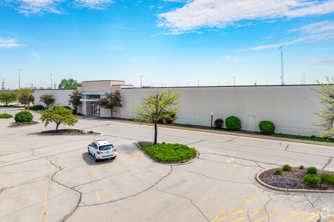

This Property Is For Sale
Property Detail
4301 W Wisconsin Ave
10-1-1203-01
COM W1/4 COR SEC29 N880FT E990FT N1693.76FT S39D E451.59 FT TO POB S80D E219.71FT S10D W392FT S80D E648.20FT N10D E704.77FT W357.93FT THENCE ALG ARC OF A725FT RADIUS CURVE TO LEFT 511.55FT TO POB PRT N1/2 NW SEC29 T21N R17E
Commercialnec
Outagamie
B and X Area of moderate flood hazard, usually the area between the limits of the 100-year and 500-year floods.
Wisconsin
2024
8.94 AC
2024
Outagamie County
0125062026
Green Bay
136,548 SF
Appleton, WI
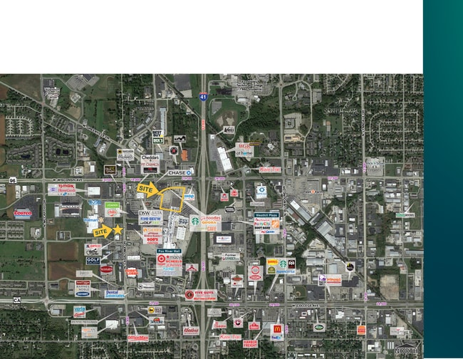
NEARBY LISTINGS FOR SALE OR LEASE
DEMOGRAPHICS near 4301 W Wisconsin Ave
1 mile
3 mile
5 mile
2025 Total Population
2,150
45,412
126,434
2030 Population
2,184
46,112
128,745
Pop Growth 2025-2030
+ 1.58%
+ 1.54%
+ 1.83%
Average Age
41
40
40
2025 Total Households
1,059
19,388
52,853
HH Growth 2025-2030
+ 1.51%
+ 1.55%
+ 1.90%
Median Household Inc
$69,503
$80,146
$78,166
Avg Household Size
1.90
2.20
2.30
2025 Avg HH Vehicles
2.00
2.00
2.00
Median Home Value
$244,488
$252,653
$248,116
Median Year Built
1992
1978
1976
Nearby Places
Map Layers
Map Styles
 Street
 Aerial
Transit
 Traffic
 Biking
Places
Listings with unknown addresses are not visible on the map
- Restaurants
- Banks
- Shops
- Fitness
- Groceries
PUBLIC TRANSPORTATION
AIRPORT
Appleton International
Drive
Walk
Distance
Appleton International
13 min
5.6 mi
Green Bay/Austin Straubel International
Drive
Walk
Distance
Green Bay/Austin Straubel International
40 min
30.3 mi
Freight Ports
Port Milwaukee
Drive
Walk
Distance
Port Milwaukee
126 min
107.4 mi
Nearby Properties
Address
Land Use
TOTAL SIZE
Lot Size
Zoning
Address
Land Use
TOTAL SIZE
Lot Size
Zoning
68.77 AC
Address
Land Use
TOTAL SIZE
Lot Size
Zoning
645,392 SF
25.87 AC
Address
Land Use
TOTAL SIZE
Lot Size
Zoning
8.61 AC
R5
Address
Land Use
TOTAL SIZE
Lot Size
Zoning
500,700 SF
47.17 AC
Address
Land Use
TOTAL SIZE
Lot Size
Zoning
Address
Land Use
TOTAL SIZE
Lot Size
Zoning
267,069 SF
26.76 AC
Address
Land Use
TOTAL SIZE
Lot Size
Zoning
18.34 AC
Address
Land Use
TOTAL SIZE
Lot Size
Zoning
278,801 SF
20.94 AC
Address
Land Use
TOTAL SIZE
Lot Size
Zoning
23.68 AC
Address
Land Use
TOTAL SIZE
Lot Size
Zoning
37,900 SF
0.67 AC
Address
Land Use
TOTAL SIZE
Lot Size
Zoning
148,743 SF
17.58 AC
Address
Land Use
TOTAL SIZE
Lot Size
Zoning
15.06 AC
Address
Land Use
TOTAL SIZE
Lot Size
Zoning
81,252 SF
8.32 AC
Address
Land Use
TOTAL SIZE
Lot Size
Zoning
34,232 SF
18.18 AC
Address
Land Use
TOTAL SIZE
Lot Size
Zoning
20.92 AC
R5
Address
Land Use
TOTAL SIZE
Lot Size
Zoning
249,444 SF
18.81 AC
Address
Land Use
TOTAL SIZE
Lot Size
Zoning
30.16 AC
Address
Land Use
TOTAL SIZE
Lot Size
Zoning
82,199 SF
6.97 AC
Address
Land Use
TOTAL SIZE
Lot Size
Zoning
194,738 SF
19.73 AC
Address
Land Use
TOTAL SIZE
Lot Size
Zoning
83,926 SF
7.35 AC
C2
Address
Land Use
TOTAL SIZE
Lot Size
Zoning
1.91 AC
B5
Address
Land Use
TOTAL SIZE
Lot Size
Zoning
18.18 AC
I1
Address
Land Use
TOTAL SIZE
Lot Size
Zoning
22.26 AC
Address
Land Use
TOTAL SIZE
Lot Size
Zoning
25.59 AC
Address
Land Use
TOTAL SIZE
Lot Size
Zoning
248,212 SF
7.87 AC
M2
Address
Land Use
TOTAL SIZE
Lot Size
Zoning
39,510 SF
7.73 AC
Address
Land Use
TOTAL SIZE
Lot Size
Zoning
189,722 SF
21.52 AC
Address
Land Use
TOTAL SIZE
Lot Size
Zoning
12.02 AC
M2
Address
Land Use
TOTAL SIZE
Lot Size
Zoning
97,355 SF
7.99 AC
Address
Land Use
TOTAL SIZE
Lot Size
Zoning
14.03 AC
The World's #1 Commercial Real Estate Marketplace
Connect with us
© 2026 CoStar Group
The information above has been obtained from sources believed reliable. While we do not doubt its accuracy we have not verified it and make no guarantee, warranty or representation about it. It is your responsibility to independently confirm its accuracy and completeness. Any projections, opinions, assumptions, or estimates used are for example only and do not represent the current or future performance of the property. The value of this transaction to you depends on tax and other factors which should be evaluated by your tax, financial, and legal advisors. You and your advisors should conduct a careful, independent investigation of the property to determine to your satisfaction the suitability of the property for your needs.