Property Record
4305 W 46Th Ave, Denver, CO 80212


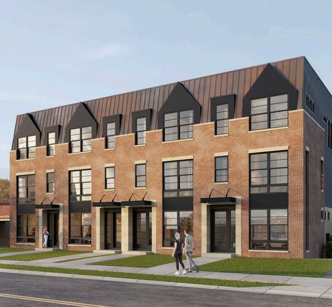
This Property Is For Sale
NEARBY LISTINGS FOR SALE OR LEASE
Property Detail
4305 W 46Th Ave
Denver
Follmers Sub
Denver-Aurora-Lakewood, CO
Denver
2191-06-038
Colorado
Townhouserowhouse
1.18 AC
1,517 SF
Berkeley
DEMOGRAPHICS near 4305 W 46Th Ave
1 Mile
3 Mile
5 Mile
2024 Total Population
17,394
154,775
430,044
2029 Population
17,382
157,023
436,582
Pop Growth 2024-2029
(0.07%)
+ 1.45%
+ 1.52%
Average Age
38
38
38
2024 Total Households
7,732
72,548
196,215
HH Growth 2024-2029
(0.36%)
+ 1.36%
+ 1.60%
Median Household Inc
$108,845
$90,407
$78,711
Avg Household Size
2.10
2.10
2.10
2024 Avg HH Vehicles
2.00
2.00
2.00
Median Home Value
$702,638
$614,893
$521,181
Median Year Built
1952
1973
1972
Nearby Places
Map Layers
Map Styles
 Street
 Aerial
- Restaurants
- Banks
- Shops
- Fitness
- Groceries
PUBLIC TRANSPORTATION
COMMUTER RAIL
60Th & Sheridan - Arvada Gold Strike Station Track 1 (Union Station to Wheat Ridge Ward Station - Regional Transportation District)
DRIVE
WALK
Distance
60Th & Sheridan - Arvada Gold Strike Station Track 1 (Union Station to Wheat Ridge Ward Station - Regional Transportation District)
7 min
2.9 mi
Clear Creek - Federal Station Track 1 (Union Station to Wheat Ridge Ward Station - Regional Transportation District)
DRIVE
WALK
Distance
Clear Creek - Federal Station Track 1 (Union Station to Wheat Ridge Ward Station - Regional Transportation District)
7 min
2.9 mi
AIRPORT
Denver International
DRIVE
WALK
Distance
Denver International
33 min
25.3 mi
Freight Ports
Tulsa Port Of Catoosa
DRIVE
WALK
Distance
Tulsa Port Of Catoosa
730 min
710.8 mi
Nearby Properties
Address
Land Use
TOTAL SIZE
Lot Size
Zoning
Address
Land Use
TOTAL SIZE
Lot Size
Zoning
1,721,086 SF
21.34 AC
C-MU-30
Address
Land Use
TOTAL SIZE
Lot Size
Zoning
611,828 SF
0.94 AC
PUD
Address
Land Use
TOTAL SIZE
Lot Size
Zoning
150,202 SF
13.24 AC
T-MU-30
Address
Land Use
TOTAL SIZE
Lot Size
Zoning
298,387 SF
0.88 AC
PUD
Address
Land Use
TOTAL SIZE
Lot Size
Zoning
405,974 SF
1.78 AC
PUD
Address
Land Use
TOTAL SIZE
Lot Size
Zoning
290,821 SF
1.16 AC
PUD
Address
Land Use
TOTAL SIZE
Lot Size
Zoning
334,746 SF
1.25 AC
D-LD
Address
Land Use
TOTAL SIZE
Lot Size
Zoning
860,132 SF
68.50 AC
R-5
Address
Land Use
TOTAL SIZE
Lot Size
Zoning
424,862 SF
32.28 AC
G-MU-3
Address
Land Use
TOTAL SIZE
Lot Size
Zoning
303,752 SF
1.26 AC
D-LD
Address
Land Use
TOTAL SIZE
Lot Size
Zoning
729,679 SF
C-MX
Address
Land Use
TOTAL SIZE
Lot Size
Zoning
218,176 SF
0.62 AC
T-MU-30
Address
Land Use
TOTAL SIZE
Lot Size
Zoning
265,054 SF
1.39 AC
C-MX-5
Address
Land Use
TOTAL SIZE
Lot Size
Zoning
33.40 AC
C-MU-30
Address
Land Use
TOTAL SIZE
Lot Size
Zoning
203,148 SF
1.36 AC
C-MX-5
Address
Land Use
TOTAL SIZE
Lot Size
Zoning
44.93 AC
CPV-C
Address
Land Use
TOTAL SIZE
Lot Size
Zoning
212,252 SF
0.93 AC
D-LD
Address
Land Use
TOTAL SIZE
Lot Size
Zoning
268,690 SF
1.23 AC
PUD
Address
Land Use
TOTAL SIZE
Lot Size
Zoning
168,523 SF
44.89 AC
CPV-R
Address
Land Use
TOTAL SIZE
Lot Size
Zoning
921,863 SF
2.01 AC
C-MX
Address
Land Use
TOTAL SIZE
Lot Size
Zoning
798,837 SF
1.67 AC
C-MX
Address
Land Use
TOTAL SIZE
Lot Size
Zoning
159,202 SF
1.03 AC
C-MX-5
Address
Land Use
TOTAL SIZE
Lot Size
Zoning
8,295 SF
2.57 AC
C-RX
Address
Land Use
TOTAL SIZE
Lot Size
Zoning
35,364 SF
1.12 AC
T-MU
Address
Land Use
TOTAL SIZE
Lot Size
Zoning
398,180 SF
33.31 AC
R1C
Address
Land Use
TOTAL SIZE
Lot Size
Zoning
163,956 SF
0.89 AC
T-MU-30
Address
Land Use
TOTAL SIZE
Lot Size
Zoning
102,550 SF
1.06 AC
T-MU
Address
Land Use
TOTAL SIZE
Lot Size
Zoning
827,707 SF
19 AC
C-MU-30
Address
Land Use
TOTAL SIZE
Lot Size
Zoning
470,539 SF
23.59 AC
Address
Land Use
TOTAL SIZE
Lot Size
Zoning
109,234 SF
0.77 AC
PUD
The World's #1 Commercial Real Estate Marketplace
Connect with us
© 2025 CoStar Group
The information above has been obtained from sources believed reliable. While we do not doubt its accuracy we have not verified it and make no guarantee, warranty or representation about it. It is your responsibility to independently confirm its accuracy and completeness. Any projections, opinions, assumptions, or estimates used are for example only and do not represent the current or future performance of the property. The value of this transaction to you depends on tax and other factors which should be evaluated by your tax, financial, and legal advisors. You and your advisors should conduct a careful, independent investigation of the property to determine to your satisfaction the suitability of the property for your needs.