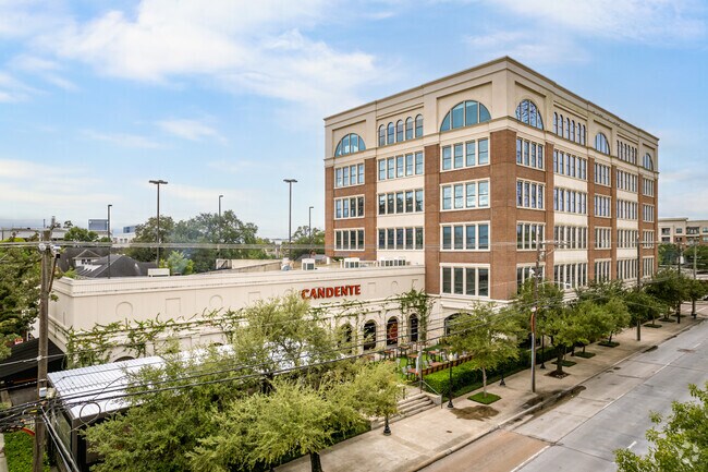
Property Record
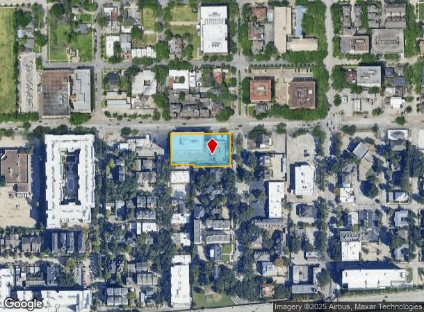
4306 Yoakum Blvd, Houston, TX 77006

Current Lease Availabilities
NEARBY LISTINGS FOR SALE OR LEASE
Property Detail
4306 Yoakum Blvd
0302490010001
Rossmoyne Par R/P
Officebuilding
RES A BLK 1 (SINGLE-FAMILY RESIDENTIAL) ROSSMOYNE PAR R/P
X
Harris
48201C0860L
Texas
2024
1.04 AC
2025
Midtown
410900
Houston
120,472 SF
Houston-The Woodlands-Sugar Land, TX
DEMOGRAPHICS near 4306 Yoakum Blvd
1 Mile
3 Mile
5 Mile
2024 Total Population
31,059
230,707
511,447
2029 Population
32,462
240,470
531,885
Pop Growth 2024-2029
+ 4.52%
+ 4.23%
+ 4.00%
Average Age
40
37
38
2024 Total Households
16,897
115,681
238,623
HH Growth 2024-2029
+ 4.57%
+ 4.43%
+ 4.22%
Median Household Inc
$87,930
$92,996
$83,517
Avg Household Size
1.70
1.80
2.00
2024 Avg HH Vehicles
1.00
1.00
2.00
Median Home Value
$617,622
$499,414
$468,618
Median Year Built
1993
2000
1996
Nearby Places
Map Layers
Map Styles
 Street
 Aerial
- Restaurants
- Banks
- Shops
- Fitness
- Groceries
PUBLIC TRANSPORTATION
TRANSIT/SUBWAY
Wheeler (Redline - Harris County Metropolitan Transit Authority METRO Rail (METRORail))
DRIVE
WALK
Distance
Wheeler (Redline - Harris County Metropolitan Transit Authority METRO Rail (METRORail))
7 min
14 min
0.7 mi
Museum District Southbound (Redline - Harris County Metropolitan Transit Authority METRO Rail (METRORail))
DRIVE
WALK
Distance
Museum District Southbound (Redline - Harris County Metropolitan Transit Authority METRO Rail (METRORail))
2 min
17 min
0.9 mi
Museum District Northbound (Redline - Harris County Metropolitan Transit Authority METRO Rail (METRORail))
DRIVE
WALK
Distance
Museum District Northbound (Redline - Harris County Metropolitan Transit Authority METRO Rail (METRORail))
2 min
18 min
0.9 mi
Ensemble/HCC (Redline - Harris County Metropolitan Transit Authority METRO Rail (METRORail))
DRIVE
WALK
Distance
Ensemble/HCC (Redline - Harris County Metropolitan Transit Authority METRO Rail (METRORail))
2 min
20 min
1.0 mi
COMMUTER RAIL
DRIVE
WALK
Distance
9 min
3.6 mi
AIRPORT
William P Hobby
DRIVE
WALK
Distance
William P Hobby
26 min
13.1 mi
George Bush Intcntl/Houston
DRIVE
WALK
Distance
George Bush Intcntl/Houston
31 min
22.3 mi
Freight Ports
Port of Houston
DRIVE
WALK
Distance
Port of Houston
22 min
12.4 mi
Nearby Properties
Address
Land Use
TOTAL SIZE
Lot Size
Zoning
Address
Land Use
TOTAL SIZE
Lot Size
Zoning
1,383,720 SF
1.47 AC
Address
Land Use
TOTAL SIZE
Lot Size
Zoning
1,101,686 SF
1.45 AC
Address
Land Use
TOTAL SIZE
Lot Size
Zoning
973,861 SF
1.18 AC
Address
Land Use
TOTAL SIZE
Lot Size
Zoning
899,279 SF
1.18 AC
Address
Land Use
TOTAL SIZE
Lot Size
Zoning
797,208 SF
1.46 AC
Address
Land Use
TOTAL SIZE
Lot Size
Zoning
519,409 SF
1.52 AC
Address
Land Use
TOTAL SIZE
Lot Size
Zoning
1,916,394 SF
1.46 AC
Address
Land Use
TOTAL SIZE
Lot Size
Zoning
1,871,418 SF
1.44 AC
Address
Land Use
TOTAL SIZE
Lot Size
Zoning
1,252,274 SF
2.02 AC
Address
Land Use
TOTAL SIZE
Lot Size
Zoning
1,880,742 SF
20.77 AC
Address
Land Use
TOTAL SIZE
Lot Size
Zoning
1,091,726 SF
2.60 AC
Address
Land Use
TOTAL SIZE
Lot Size
Zoning
1,232,364 SF
1.49 AC
Address
Land Use
TOTAL SIZE
Lot Size
Zoning
1,436,400 SF
1.44 AC
Address
Land Use
TOTAL SIZE
Lot Size
Zoning
1,321,033 SF
1.46 AC
Address
Land Use
TOTAL SIZE
Lot Size
Zoning
4,169,721 SF
31.23 AC
Address
Land Use
TOTAL SIZE
Lot Size
Zoning
2,005,097 SF
1.44 AC
Address
Land Use
TOTAL SIZE
Lot Size
Zoning
1,374,271 SF
1.44 AC
Address
Land Use
TOTAL SIZE
Lot Size
Zoning
1,150,681 SF
1.17 AC
Address
Land Use
TOTAL SIZE
Lot Size
Zoning
515,025 SF
1.50 AC
Address
Land Use
TOTAL SIZE
Lot Size
Zoning
704,249 SF
2.34 AC
Address
Land Use
TOTAL SIZE
Lot Size
Zoning
1,657,484 SF
1.44 AC
Address
Land Use
TOTAL SIZE
Lot Size
Zoning
1,282,908 SF
2.74 AC
Address
Land Use
TOTAL SIZE
Lot Size
Zoning
1,311,133 SF
1.44 AC
Address
Land Use
TOTAL SIZE
Lot Size
Zoning
555,351 SF
1.40 AC
Address
Land Use
TOTAL SIZE
Lot Size
Zoning
1,181,384 SF
1.47 AC
Address
Land Use
TOTAL SIZE
Lot Size
Zoning
1,044,305 SF
3.16 AC
Address
Land Use
TOTAL SIZE
Lot Size
Zoning
1,162,204 SF
1.44 AC
Address
Land Use
TOTAL SIZE
Lot Size
Zoning
934,258 SF
1.45 AC
Address
Land Use
TOTAL SIZE
Lot Size
Zoning
1,103,424 SF
1.44 AC
Address
Land Use
TOTAL SIZE
Lot Size
Zoning
1,359,194 SF
The World's #1 Commercial Real Estate Marketplace
Connect with us
© 2025 CoStar Group
The information above has been obtained from sources believed reliable. While we do not doubt its accuracy we have not verified it and make no guarantee, warranty or representation about it. It is your responsibility to independently confirm its accuracy and completeness. Any projections, opinions, assumptions, or estimates used are for example only and do not represent the current or future performance of the property. The value of this transaction to you depends on tax and other factors which should be evaluated by your tax, financial, and legal advisors. You and your advisors should conduct a careful, independent investigation of the property to determine to your satisfaction the suitability of the property for your needs.