Property Record
4318 Northfield Ln, Houston, TX 77092
NEARBY LISTINGS FOR SALE OR LEASE
Property Detail
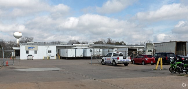
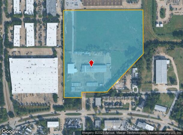
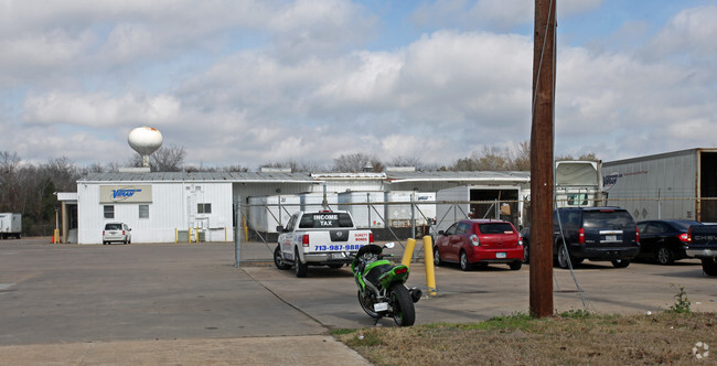
4318 Northfield Ln
1354160010001
Geospace Tech Sec 1
Truckterminal
RES A BLK 1 GEOSPACE TECH SEC 1
AE
Harris
48201C0655M
Texas
2024
17.33 AC
2025
Northwest Inner Loop
520502
Houston
20,966 SF
Houston-The Woodlands-Sugar Land, TX
DEMOGRAPHICS near 4318 Northfield Ln
1 Mile
3 Mile
5 Mile
2024 Total Population
14,776
142,339
325,211
2029 Population
15,202
146,117
333,786
Pop Growth 2024-2029
+ 2.88%
+ 2.65%
+ 2.64%
Average Age
32
35
37
2024 Total Households
4,745
52,296
120,183
HH Growth 2024-2029
+ 2.53%
+ 2.64%
+ 2.74%
Median Household Inc
$39,932
$47,327
$59,117
Avg Household Size
2.90
2.60
2.60
2024 Avg HH Vehicles
2.00
2.00
2.00
Median Home Value
$181,933
$260,214
$294,077
Median Year Built
1975
1977
1978
Nearby Places
Map Layers
Map Styles
 Street
 Aerial
- Restaurants
- Banks
- Shops
- Fitness
- Groceries
PUBLIC TRANSPORTATION
AIRPORT
George Bush Intcntl/Houston
DRIVE
WALK
Distance
George Bush Intcntl/Houston
32 min
21.1 mi
William P Hobby
DRIVE
WALK
Distance
William P Hobby
42 min
25.7 mi
Freight Ports
Port of Houston
DRIVE
WALK
Distance
Port of Houston
34 min
21.4 mi
SALE & LEASE HISTORY
LISTING DATE
SALE/LEASE

Sep 13, 2024
For Sale
Nearby Properties
Address
Land Use
TOTAL SIZE
Lot Size
Zoning
Address
Land Use
TOTAL SIZE
Lot Size
Zoning
793,669 SF
121.83 AC
Address
Land Use
TOTAL SIZE
Lot Size
Zoning
504,256 SF
6.09 AC
Address
Land Use
TOTAL SIZE
Lot Size
Zoning
350,655 SF
16.76 AC
Address
Land Use
TOTAL SIZE
Lot Size
Zoning
643,804 SF
31.40 AC
Address
Land Use
TOTAL SIZE
Lot Size
Zoning
293,407 SF
9.19 AC
Address
Land Use
TOTAL SIZE
Lot Size
Zoning
456,294 SF
19.02 AC
Address
Land Use
TOTAL SIZE
Lot Size
Zoning
802,913 SF
27.11 AC
Address
Land Use
TOTAL SIZE
Lot Size
Zoning
308,168 SF
21.34 AC
Address
Land Use
TOTAL SIZE
Lot Size
Zoning
387,788 SF
17.95 AC
Address
Land Use
TOTAL SIZE
Lot Size
Zoning
426,748 SF
26.09 AC
Address
Land Use
TOTAL SIZE
Lot Size
Zoning
229,369 SF
4 AC
Address
Land Use
TOTAL SIZE
Lot Size
Zoning
401,600 SF
20.48 AC
Address
Land Use
TOTAL SIZE
Lot Size
Zoning
409,271 SF
20.70 AC
Address
Land Use
TOTAL SIZE
Lot Size
Zoning
447,480 SF
18.48 AC
Address
Land Use
TOTAL SIZE
Lot Size
Zoning
444,798 SF
17.17 AC
Address
Land Use
TOTAL SIZE
Lot Size
Zoning
185,252 SF
17.14 AC
Address
Land Use
TOTAL SIZE
Lot Size
Zoning
287,212 SF
12.52 AC
Address
Land Use
TOTAL SIZE
Lot Size
Zoning
358,361 SF
11.35 AC
Address
Land Use
TOTAL SIZE
Lot Size
Zoning
336,050 SF
14.41 AC
Address
Land Use
TOTAL SIZE
Lot Size
Zoning
330,161 SF
20.90 AC
Address
Land Use
TOTAL SIZE
Lot Size
Zoning
268,678 SF
14 AC
Address
Land Use
TOTAL SIZE
Lot Size
Zoning
415,860 SF
34.04 AC
Address
Land Use
TOTAL SIZE
Lot Size
Zoning
257,400 SF
13.34 AC
Address
Land Use
TOTAL SIZE
Lot Size
Zoning
299,640 SF
13.95 AC
Address
Land Use
TOTAL SIZE
Lot Size
Zoning
407,702 SF
15.73 AC
Address
Land Use
TOTAL SIZE
Lot Size
Zoning
308,148 SF
11.85 AC
Address
Land Use
TOTAL SIZE
Lot Size
Zoning
145,132 SF
3.69 AC
Address
Land Use
TOTAL SIZE
Lot Size
Zoning
407,512 SF
16.75 AC
Address
Land Use
TOTAL SIZE
Lot Size
Zoning
377,771 SF
19.76 AC
Address
Land Use
TOTAL SIZE
Lot Size
Zoning
206,777 SF
8.77 AC
The World's #1 Commercial Real Estate Marketplace
Connect with us
© 2025 CoStar Group
The information above has been obtained from sources believed reliable. While we do not doubt its accuracy we have not verified it and make no guarantee, warranty or representation about it. It is your responsibility to independently confirm its accuracy and completeness. Any projections, opinions, assumptions, or estimates used are for example only and do not represent the current or future performance of the property. The value of this transaction to you depends on tax and other factors which should be evaluated by your tax, financial, and legal advisors. You and your advisors should conduct a careful, independent investigation of the property to determine to your satisfaction the suitability of the property for your needs.