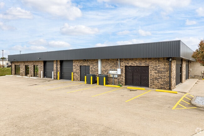
Property Record
437 Southfork Dr, Lewisville, TX 75057


Save to a Folder
{{folder.Name}}
{{folder.ListingIds.length}} Properties
{{folder.ListingIds.length}} Property
Create a New Folder
Current Lease Availabilities
Property Detail
437 Southfork Dr
Dallas-Fort Worth-Arlington, TX
PRAIRIE CREEK ADDN PH 4 BLK A LOT 6
R86213
Denton
Commercialnec
Texas
AE The base floodplain where base flood elevations are provided. AE Zones are now used on new format FIRMs instead of A1-A30 Zones.
6
2024
0.33 AC
2025
Lewisville
021618
Dallas/Ft Worth
5,500 SF
NEARBY LISTINGS FOR SALE OR LEASE
DEMOGRAPHICS near 437 Southfork Dr
1 mile
3 mile
5 mile
2025 Total Population
7,609
83,711
203,645
2030 Population
8,768
93,380
226,611
Pop Growth 2025-2030
+ 15.23%
+ 11.55%
+ 11.28%
Average Age
38
38
39
2025 Total Households
2,603
30,154
76,372
HH Growth 2025-2030
+ 15.64%
+ 11.84%
+ 11.57%
Median Household Inc
$66,435
$88,024
$98,959
Avg Household Size
2.70
2.70
2.60
2025 Avg HH Vehicles
2.00
2.00
2.00
Median Home Value
$317,500
$349,180
$420,510
Median Year Built
1993
1989
1995
Nearby Places
Map Layers
Map Styles
 Street
 Aerial
Layers
 Traffic
 Biking
Places
Listings with unknown addresses are not visible on the map
- Restaurants
- Banks
- Shops
- Fitness
- Groceries
PUBLIC TRANSPORTATION
COMMUTER RAIL
Drive
Walk
Distance
4 min
1.4 mi
Drive
Walk
Distance
5 min
2.8 mi
AIRPORT
Dallas-Fort Worth International
Drive
Walk
Distance
Dallas-Fort Worth International
20 min
12.9 mi
Dallas Love Field
Drive
Walk
Distance
Dallas Love Field
32 min
22.4 mi
Nearby Properties
Address
Land Use
TOTAL SIZE
Lot Size
Zoning
Address
Land Use
TOTAL SIZE
Lot Size
Zoning
334,685 SF
38.12 AC
Address
Land Use
TOTAL SIZE
Lot Size
Zoning
599,705 SF
10.38 AC
Address
Land Use
TOTAL SIZE
Lot Size
Zoning
323,048 SF
14.78 AC
Address
Land Use
TOTAL SIZE
Lot Size
Zoning
189,200 SF
5.08 AC
Address
Land Use
TOTAL SIZE
Lot Size
Zoning
340,081 SF
18.06 AC
6
Address
Land Use
TOTAL SIZE
Lot Size
Zoning
380,316 SF
26.10 AC
Address
Land Use
TOTAL SIZE
Lot Size
Zoning
295,098 SF
10.65 AC
Address
Land Use
TOTAL SIZE
Lot Size
Zoning
266,959 SF
3.83 AC
Address
Land Use
TOTAL SIZE
Lot Size
Zoning
297,636 SF
9.43 AC
Address
Land Use
TOTAL SIZE
Lot Size
Zoning
295,668 SF
13.03 AC
Address
Land Use
TOTAL SIZE
Lot Size
Zoning
344,932 SF
18.28 AC
3G
Address
Land Use
TOTAL SIZE
Lot Size
Zoning
212,454 SF
13 AC
6B
Address
Land Use
TOTAL SIZE
Lot Size
Zoning
572,808 SF
25.26 AC
Address
Land Use
TOTAL SIZE
Lot Size
Zoning
244,310 SF
6.24 AC
Address
Land Use
TOTAL SIZE
Lot Size
Zoning
440,000 SF
3.67 AC
Address
Land Use
TOTAL SIZE
Lot Size
Zoning
99,272 SF
16.60 AC
Address
Land Use
TOTAL SIZE
Lot Size
Zoning
241,095 SF
13.02 AC
Address
Land Use
TOTAL SIZE
Lot Size
Zoning
268,441 SF
13.89 AC
3G
Address
Land Use
TOTAL SIZE
Lot Size
Zoning
134,061 SF
17.87 AC
Address
Land Use
TOTAL SIZE
Lot Size
Zoning
221,320 SF
12.79 AC
6B
Address
Land Use
TOTAL SIZE
Lot Size
Zoning
190,114 SF
9.88 AC
5G
Address
Land Use
TOTAL SIZE
Lot Size
Zoning
160,648 SF
4.70 AC
Address
Land Use
TOTAL SIZE
Lot Size
Zoning
233,789 SF
10.39 AC
3G
Address
Land Use
TOTAL SIZE
Lot Size
Zoning
223,495 SF
11.68 AC
3A
Address
Land Use
TOTAL SIZE
Lot Size
Zoning
218,030 SF
10.32 AC
3A
Address
Land Use
TOTAL SIZE
Lot Size
Zoning
208,268 SF
11.23 AC
6G
Address
Land Use
TOTAL SIZE
Lot Size
Zoning
233,712 SF
11.44 AC
3G
Address
Land Use
TOTAL SIZE
Lot Size
Zoning
367,744 SF
20.18 AC
Address
Land Use
TOTAL SIZE
Lot Size
Zoning
206,954 SF
9.46 AC
3A
Address
Land Use
TOTAL SIZE
Lot Size
Zoning
179,120 SF
7.66 AC
6G
The World's #1 Commercial Real Estate Marketplace
Connect with us
© 2026 CoStar Group
The information above has been obtained from sources believed reliable. While we do not doubt its accuracy we have not verified it and make no guarantee, warranty or representation about it. It is your responsibility to independently confirm its accuracy and completeness. Any projections, opinions, assumptions, or estimates used are for example only and do not represent the current or future performance of the property. The value of this transaction to you depends on tax and other factors which should be evaluated by your tax, financial, and legal advisors. You and your advisors should conduct a careful, independent investigation of the property to determine to your satisfaction the suitability of the property for your needs.