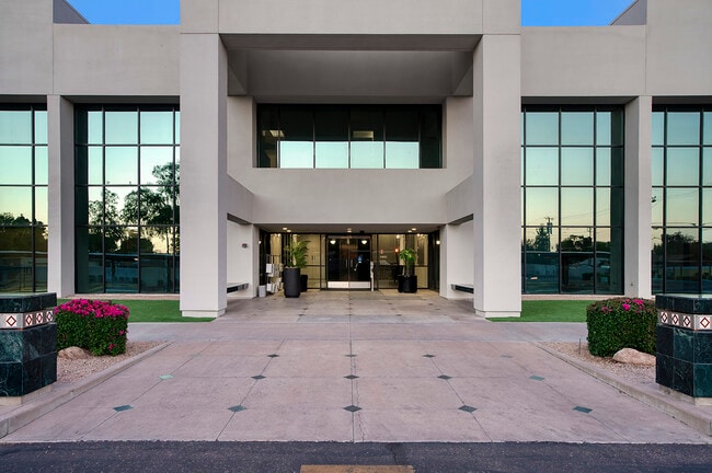
Property Record
4348 N 32Nd St, Phoenix, AZ 85018
Save to a Folder
{{folder.Name}}
{{folder.ListingIds.length}} Properties
{{folder.ListingIds.length}} Property
Create a New Folder
Property Detail
4348 N 32Nd St
163-03-127D
N 131.5F OF E 450F OF S2 NE4 SE4 OF SD SEC EX W 1 50F & EX E 40F RD ALSO EX THAT TRI P/D 11543/0166
Commercialnec
MARICOPA
C-T
Arizona
C and X Area of minimal flood hazard, usually depicted on FIRMs as above the 500-year flood level.
0.79 AC
2025
Midtown/Central Phoenix
2025
Phoenix
108400
Phoenix-Mesa-Chandler, AZ
13,069 SF
NEARBY LISTINGS FOR SALE OR LEASE
DEMOGRAPHICS near 4348 N 32Nd St
1 mile
3 mile
5 mile
2025 Total Population
19,976
145,316
316,128
2030 Population
21,017
151,745
331,392
Pop Growth 2025-2030
+ 5.21%
+ 4.42%
+ 4.83%
Average Age
40
39
39
2025 Total Households
10,060
64,785
144,323
HH Growth 2025-2030
+ 5.26%
+ 4.59%
+ 5.04%
Median Household Inc
$93,972
$79,782
$79,132
Avg Household Size
1.90
2.20
2.10
2025 Avg HH Vehicles
2.00
2.00
2.00
Median Home Value
$769,702
$671,731
$675,238
Median Year Built
1973
1972
1974
Nearby Places
Map Layers
Map Styles
 Street
 Aerial
Layers
 Traffic
 Biking
Places
Listings with unknown addresses are not visible on the map
- Restaurants
- Banks
- Shops
- Fitness
- Groceries
PUBLIC TRANSPORTATION
AIRPORT
Phoenix Sky Harbor International
Drive
Walk
Distance
Phoenix Sky Harbor International
14 min
7.5 mi
Phoenix-Mesa Gateway
Drive
Walk
Distance
Phoenix-Mesa Gateway
46 min
32.3 mi
Freight Ports
Port of San Diego
Drive
Walk
Distance
Port of San Diego
403 min
360.9 mi
SALE & LEASE HISTORY
LISTING DATE
SALE/LEASE

Sep 24, 2016
For Lease
Jul 01, 2025
For Lease
Nearby Properties
Address
Land Use
TOTAL SIZE
Lot Size
Zoning
Address
Land Use
TOTAL SIZE
Lot Size
Zoning
2,006,402 SF
18.66 AC
C-C
Address
Land Use
TOTAL SIZE
Lot Size
Zoning
103,415 SF
4.61 AC
C-T
Address
Land Use
TOTAL SIZE
Lot Size
Zoning
71,306 SF
8.93 AC
M-H
Address
Land Use
TOTAL SIZE
Lot Size
Zoning
969,844 SF
27.97 AC
PAD
Address
Land Use
TOTAL SIZE
Lot Size
Zoning
953,192 SF
28.99 AC
Address
Land Use
TOTAL SIZE
Lot Size
Zoning
50,161 SF
2.05 AC
M-H
Address
Land Use
TOTAL SIZE
Lot Size
Zoning
410,000 SF
1.86 AC
C-C
Address
Land Use
TOTAL SIZE
Lot Size
Zoning
386,004 SF
37.82 AC
R-6
Address
Land Use
TOTAL SIZE
Lot Size
Zoning
812,968 SF
7.08 AC
Address
Land Use
TOTAL SIZE
Lot Size
Zoning
402,448 SF
24.08 AC
C-C
Address
Land Use
TOTAL SIZE
Lot Size
Zoning
517,609 SF
1.67 AC
C-C
Address
Land Use
TOTAL SIZE
Lot Size
Zoning
599,524 SF
5.09 AC
R5
Address
Land Use
TOTAL SIZE
Lot Size
Zoning
656,952 SF
3.58 AC
Address
Land Use
TOTAL SIZE
Lot Size
Zoning
23,462 SF
1.91 AC
C-C
Address
Land Use
TOTAL SIZE
Lot Size
Zoning
567,481 SF
2 AC
Address
Land Use
TOTAL SIZE
Lot Size
Zoning
575,103 SF
2.24 AC
Address
Land Use
TOTAL SIZE
Lot Size
Zoning
312,104 SF
1.08 AC
C-2
Address
Land Use
TOTAL SIZE
Lot Size
Zoning
29,100 SF
1.42 AC
M-H
Address
Land Use
TOTAL SIZE
Lot Size
Zoning
282,287 SF
38.68 AC
R-10
Address
Land Use
TOTAL SIZE
Lot Size
Zoning
812,214 SF
4.91 AC
C-C
Address
Land Use
TOTAL SIZE
Lot Size
Zoning
266,869 SF
7.55 AC
C-C
Address
Land Use
TOTAL SIZE
Lot Size
Zoning
426,310 SF
1.44 AC
Address
Land Use
TOTAL SIZE
Lot Size
Zoning
536,856 SF
20.27 AC
PSC
Address
Land Use
TOTAL SIZE
Lot Size
Zoning
1,137 SF
76.71 AC
RE35
Address
Land Use
TOTAL SIZE
Lot Size
Zoning
341,434 SF
22.48 AC
C-T
Address
Land Use
TOTAL SIZE
Lot Size
Zoning
533,579 SF
1.91 AC
Address
Land Use
TOTAL SIZE
Lot Size
Zoning
515,440 SF
3.02 AC
C-T
Address
Land Use
TOTAL SIZE
Lot Size
Zoning
147,864 SF
6.74 AC
C-C
Address
Land Use
TOTAL SIZE
Lot Size
Zoning
508,796 SF
4.71 AC
PAD
The World's #1 Commercial Real Estate Marketplace
Connect with us
© 2026 CoStar Group
The information above has been obtained from sources believed reliable. While we do not doubt its accuracy we have not verified it and make no guarantee, warranty or representation about it. It is your responsibility to independently confirm its accuracy and completeness. Any projections, opinions, assumptions, or estimates used are for example only and do not represent the current or future performance of the property. The value of this transaction to you depends on tax and other factors which should be evaluated by your tax, financial, and legal advisors. You and your advisors should conduct a careful, independent investigation of the property to determine to your satisfaction the suitability of the property for your needs.