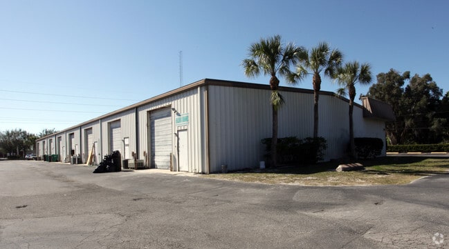
Property Record
4401 Ashton Rd, Sarasota, FL 34233


Save to a Folder
{{folder.Name}}
{{folder.ListingIds.length}} Properties
{{folder.ListingIds.length}} Property
Create a New Folder
Property Detail
4401 Ashton Rd
0091-13-0003
S 1/2 OF LOT 8, BLK 2, LESS E 245 FT, LESS S 184 FT OF W 180 FT OF E 425 FT, LESS R/W FOR MCINTOSH & ASHTON RD PART OF WHICH IS DESC IN OR 2968/672, BEE RIDGE FARMS
Industrialgeneral
Sarasota
ILW
Florida
AE The base floodplain where base flood elevations are provided. AE Zones are now used on new format FIRMs instead of A1-A30 Zones.
8
2024
1.92 AC
2025
Sarasota
001509
Tampa/St Petersburg
26,500 SF
North Port-Bradenton-Sarasota, FL
NEARBY LISTINGS FOR SALE OR LEASE
DEMOGRAPHICS near 4401 Ashton Rd
1 mile
3 mile
5 mile
2025 Total Population
5,503
78,277
164,415
2030 Population
5,723
82,298
175,444
Pop Growth 2025-2030
+ 4.00%
+ 5.14%
+ 6.71%
Average Age
46
48
49
2025 Total Households
2,227
35,380
74,993
HH Growth 2025-2030
+ 3.64%
+ 5.10%
+ 6.84%
Median Household Inc
$78,325
$77,956
$82,220
Avg Household Size
2.30
2.10
2.10
2025 Avg HH Vehicles
2.00
2.00
2.00
Median Home Value
$499,897
$436,143
$487,856
Median Year Built
1984
1982
1983
Nearby Places
Map Layers
Map Styles
 Street
 Aerial
Layers
 Traffic
 Biking
Places
Listings with unknown addresses are not visible on the map
- Restaurants
- Banks
- Shops
- Fitness
- Groceries
PUBLIC TRANSPORTATION
AIRPORT
Sarasota/Bradenton International
Drive
Walk
Distance
Sarasota/Bradenton International
24 min
12.5 mi
Freight Ports
Port Manatee
Drive
Walk
Distance
Port Manatee
42 min
30.8 mi
SALE & LEASE HISTORY
LISTING DATE
SALE/LEASE

Dec 06, 2021
For Lease
Apr 11, 2017
For Lease
Nearby Properties
Address
Land Use
TOTAL SIZE
Lot Size
Zoning
Address
Land Use
TOTAL SIZE
Lot Size
Zoning
912,672 SF
88.39 AC
RMF1
Address
Land Use
TOTAL SIZE
Lot Size
Zoning
588,839 SF
42.33 AC
GU
Address
Land Use
TOTAL SIZE
Lot Size
Zoning
409,467 SF
36.72 AC
RMF2
Address
Land Use
TOTAL SIZE
Lot Size
Zoning
19,761 SF
119.20 AC
RMH
Address
Land Use
TOTAL SIZE
Lot Size
Zoning
912,253 SF
43.46 AC
PID
Address
Land Use
TOTAL SIZE
Lot Size
Zoning
370,367 SF
27.32 AC
OPI
Address
Land Use
TOTAL SIZE
Lot Size
Zoning
366,256 SF
32.53 AC
RMF3
Address
Land Use
TOTAL SIZE
Lot Size
Zoning
432,668 SF
72.05 AC
GU
Address
Land Use
TOTAL SIZE
Lot Size
Zoning
15,614 SF
104.95 AC
RMH
Address
Land Use
TOTAL SIZE
Lot Size
Zoning
258,994 SF
20.03 AC
PCD
Address
Land Use
TOTAL SIZE
Lot Size
Zoning
263,961 SF
18.88 AC
RMF3
Address
Land Use
TOTAL SIZE
Lot Size
Zoning
312,294 SF
40.21 AC
OPI
Address
Land Use
TOTAL SIZE
Lot Size
Zoning
286,775 SF
10.85 AC
RMF3
Address
Land Use
TOTAL SIZE
Lot Size
Zoning
181,467 SF
59.39 AC
RMF1
Address
Land Use
TOTAL SIZE
Lot Size
Zoning
94,981 SF
6 AC
PCD
Address
Land Use
TOTAL SIZE
Lot Size
Zoning
332,822 SF
34.74 AC
CG
Address
Land Use
TOTAL SIZE
Lot Size
Zoning
150,433 SF
10.55 AC
RMF4
Address
Land Use
TOTAL SIZE
Lot Size
Zoning
157,854 SF
8.32 AC
OPI
Address
Land Use
TOTAL SIZE
Lot Size
Zoning
223,929 SF
28.24 AC
RMF1
Address
Land Use
TOTAL SIZE
Lot Size
Zoning
87,816 SF
24.83 AC
ILW
Address
Land Use
TOTAL SIZE
Lot Size
Zoning
373,288 SF
53.07 AC
PID
Address
Land Use
TOTAL SIZE
Lot Size
Zoning
233,075 SF
19.49 AC
RMF2
Address
Land Use
TOTAL SIZE
Lot Size
Zoning
80,038 SF
28.10 AC
ILW
Address
Land Use
TOTAL SIZE
Lot Size
Zoning
133,430 SF
19.60 AC
GU
Address
Land Use
TOTAL SIZE
Lot Size
Zoning
89,418 SF
7.86 AC
GU
Address
Land Use
TOTAL SIZE
Lot Size
Zoning
205,136 SF
17.32 AC
RMF2
Address
Land Use
TOTAL SIZE
Lot Size
Zoning
166,310 SF
40.38 AC
GU
Address
Land Use
TOTAL SIZE
Lot Size
Zoning
140,372 SF
14.31 AC
CG
Address
Land Use
TOTAL SIZE
Lot Size
Zoning
56,885 SF
10.14 AC
ILW
Address
Land Use
TOTAL SIZE
Lot Size
Zoning
123,338 SF
8.53 AC
OPI
The World's #1 Commercial Real Estate Marketplace
Connect with us
© 2026 CoStar Group
The information above has been obtained from sources believed reliable. While we do not doubt its accuracy we have not verified it and make no guarantee, warranty or representation about it. It is your responsibility to independently confirm its accuracy and completeness. Any projections, opinions, assumptions, or estimates used are for example only and do not represent the current or future performance of the property. The value of this transaction to you depends on tax and other factors which should be evaluated by your tax, financial, and legal advisors. You and your advisors should conduct a careful, independent investigation of the property to determine to your satisfaction the suitability of the property for your needs.