Property Record
441 E Main St, Centerport, NY 11721


Save to a Folder
{{folder.Name}}
{{folder.ListingIds.length}} Properties
{{folder.ListingIds.length}} Property
Create a New Folder
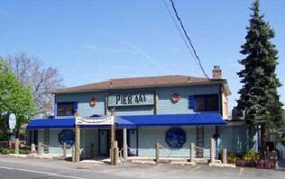
Property Detail
441 E Main St
Nassau County-Suffolk County, NY
BLK LOT
0400-044-00-01-00-008-000
Suffolk
Restaurantbuilding
New York
C6
8
VE and V1-30 Coastal areas with a 1% or greater chance of flooding and an additional hazard associated with storm waves. These areas have a 26% chance of flooding over the life of a 30-year mortgage.
0.53 AC
2024
Western Suffolk
2025
Long Island (New York)
110501
NEARBY LISTINGS FOR SALE OR LEASE
DEMOGRAPHICS near 441 E Main St
1 mile
3 mile
5 mile
2025 Total Population
6,319
60,724
147,990
2030 Population
6,278
59,976
146,103
Pop Growth 2025-2030
(0.65%)
(1.23%)
(1.28%)
Average Age
44
44
43
2025 Total Households
2,231
21,857
50,038
HH Growth 2025-2030
(0.85%)
(1.56%)
(1.54%)
Median Household Inc
$193,936
$155,120
$156,241
Avg Household Size
2.80
2.70
2.80
2025 Avg HH Vehicles
2.00
2.00
2.00
Median Home Value
$801,747
$755,934
$752,960
Median Year Built
1958
1959
1959
Nearby Places
Map Layers
Map Styles
 Street
 Aerial
Layers
 Traffic
 Biking
Places
Listings with unknown addresses are not visible on the map
- Restaurants
- Banks
- Shops
- Fitness
- Groceries
PUBLIC TRANSPORTATION
COMMUTER RAIL
Greenlawn (Port Jefferson Branch - Long Island Rail Road)
Drive
Walk
Distance
Greenlawn (Port Jefferson Branch - Long Island Rail Road)
4 min
1.8 mi
Northport (Port Jefferson Branch - Long Island Rail Road)
Drive
Walk
Distance
Northport (Port Jefferson Branch - Long Island Rail Road)
6 min
3.2 mi
AIRPORT
Long Island MacArthur
Drive
Walk
Distance
Long Island MacArthur
32 min
19.2 mi
John F Kennedy International
Drive
Walk
Distance
John F Kennedy International
53 min
34.2 mi
Freight Ports
NY - Red Hook Container Terminal
Drive
Walk
Distance
NY - Red Hook Container Terminal
62 min
40.5 mi
Nearby Properties
Address
Land Use
TOTAL SIZE
Lot Size
Zoning
Address
Land Use
TOTAL SIZE
Lot Size
Zoning
243.60 AC
I6
Address
Land Use
TOTAL SIZE
Lot Size
Zoning
42.21 AC
CA
Address
Land Use
TOTAL SIZE
Lot Size
Zoning
63,722 SF
0.42 AC
VILLA
Address
Land Use
TOTAL SIZE
Lot Size
Zoning
0.41 AC
VILLA
Address
Land Use
TOTAL SIZE
Lot Size
Zoning
2,764 SF
0.24 AC
HC
Address
Land Use
TOTAL SIZE
Lot Size
Zoning
1 AC
VILLA
Address
Land Use
TOTAL SIZE
Lot Size
Zoning
11.85 AC
RMS
Address
Land Use
TOTAL SIZE
Lot Size
Zoning
1,416 SF
0.86 AC
A
Address
Land Use
TOTAL SIZE
Lot Size
Zoning
Address
Land Use
TOTAL SIZE
Lot Size
Zoning
43.30 AC
R40
Address
Land Use
TOTAL SIZE
Lot Size
Zoning
Address
Land Use
TOTAL SIZE
Lot Size
Zoning
0.57 AC
R20
Address
Land Use
TOTAL SIZE
Lot Size
Zoning
8.80 AC
R10
Address
Land Use
TOTAL SIZE
Lot Size
Zoning
6.50 AC
R40
Address
Land Use
TOTAL SIZE
Lot Size
Zoning
0.59 AC
R20
Address
Land Use
TOTAL SIZE
Lot Size
Zoning
42.20 AC
I1
Address
Land Use
TOTAL SIZE
Lot Size
Zoning
0.50 AC
R20
Address
Land Use
TOTAL SIZE
Lot Size
Zoning
1.17 AC
BUS3
Address
Land Use
TOTAL SIZE
Lot Size
Zoning
44.90 AC
R40
Address
Land Use
TOTAL SIZE
Lot Size
Zoning
30.80 AC
R40
Address
Land Use
TOTAL SIZE
Lot Size
Zoning
10.14 AC
RRM
Address
Land Use
TOTAL SIZE
Lot Size
Zoning
0.46 AC
R20
Address
Land Use
TOTAL SIZE
Lot Size
Zoning
12 AC
RRM
Address
Land Use
TOTAL SIZE
Lot Size
Zoning
2.16 AC
CR200
Address
Land Use
TOTAL SIZE
Lot Size
Zoning
2.07 AC
CR200
Address
Land Use
TOTAL SIZE
Lot Size
Zoning
1.97 AC
CR200
Address
Land Use
TOTAL SIZE
Lot Size
Zoning
14.83 AC
R85
Address
Land Use
TOTAL SIZE
Lot Size
Zoning
16.54 AC
Address
Land Use
TOTAL SIZE
Lot Size
Zoning
1.94 AC
CR200
Address
Land Use
TOTAL SIZE
Lot Size
Zoning
1.94 AC
CR200
The World's #1 Commercial Real Estate Marketplace
Connect with us
© 2026 CoStar Group
The information above has been obtained from sources believed reliable. While we do not doubt its accuracy we have not verified it and make no guarantee, warranty or representation about it. It is your responsibility to independently confirm its accuracy and completeness. Any projections, opinions, assumptions, or estimates used are for example only and do not represent the current or future performance of the property. The value of this transaction to you depends on tax and other factors which should be evaluated by your tax, financial, and legal advisors. You and your advisors should conduct a careful, independent investigation of the property to determine to your satisfaction the suitability of the property for your needs.