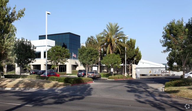
Property Record
4450 E Lowell St, Ontario, CA 91761


Current Lease Availabilities
Property Detail
4450 E Lowell St
0238-201-33
PARCEL MAP 6875 PARCELS 28 29 30 31 EX THEREFROM PTN SD PARCELS 30 AND 31 LYING SLY OF LINE BEING 670 FT SLY FROM AND MEASURED R/A TO NLY LI SD PARCELS 28 AND 29
Lightindustrial
San Bernardino
B and X Area of moderate flood hazard, usually the area between the limits of the 100-year and 500-year floods.
California
2025
14.26 AC
2025
Airport Area
012700
Inland Empire (California)
317,070 SF
Riverside-San Bernardino-Ontario, CA
NEARBY LISTINGS FOR SALE OR LEASE
DEMOGRAPHICS near 4450 E Lowell St
1 mile
3 mile
5 mile
2025 Total Population
6
31,473
235,193
2030 Population
6
32,119
238,487
Pop Growth 2025-2030
0.00%
+ 2.05%
+ 1.40%
Average Age
0
37
37
2025 Total Households
2
10,512
71,336
HH Growth 2025-2030
0.00%
+ 2.48%
+ 1.36%
Median Household Inc
$0
$96,373
$97,724
Avg Household Size
2.00
2.70
3.20
2025 Avg HH Vehicles
2.00
2.00
2.00
Median Home Value
$750,000
$675,598
$656,460
Median Year Built
1984
1993
1987
Nearby Places
Map Layers
Map Styles
 Street
 Aerial
Layers
 Traffic
 Biking
Places
Listings with unknown addresses are not visible on the map
- Restaurants
- Banks
- Shops
- Fitness
- Groceries
PUBLIC TRANSPORTATION
COMMUTER RAIL
East Ontario (Riverside Line - Southern California Regional Rail Authority (Metrolink))
Drive
Walk
Distance
East Ontario (Riverside Line - Southern California Regional Rail Authority (Metrolink))
6 min
2.3 mi
Rancho Cucamonga (San Bernardino Line - Southern California Regional Rail Authority (Metrolink))
Drive
Walk
Distance
Rancho Cucamonga (San Bernardino Line - Southern California Regional Rail Authority (Metrolink))
6 min
3.0 mi
AIRPORT
Ontario International
Drive
Walk
Distance
Ontario International
8 min
3.8 mi
Freight Ports
Port of Long Beach
Drive
Walk
Distance
Port of Long Beach
69 min
53.5 mi
Nearby Properties
Address
Land Use
TOTAL SIZE
Lot Size
Zoning
Address
Land Use
TOTAL SIZE
Lot Size
Zoning
1,459,702 SF
96.41 AC
Address
Land Use
TOTAL SIZE
Lot Size
Zoning
1,422,524 SF
44.96 AC
Address
Land Use
TOTAL SIZE
Lot Size
Zoning
1,379,287 SF
62.56 AC
Address
Land Use
TOTAL SIZE
Lot Size
Zoning
1,613,290 SF
59.42 AC
Address
Land Use
TOTAL SIZE
Lot Size
Zoning
707,551 SF
20.36 AC
Address
Land Use
TOTAL SIZE
Lot Size
Zoning
759,260 SF
42.77 AC
Address
Land Use
TOTAL SIZE
Lot Size
Zoning
817,750 SF
35.82 AC
Address
Land Use
TOTAL SIZE
Lot Size
Zoning
760,915 SF
30.34 AC
Address
Land Use
TOTAL SIZE
Lot Size
Zoning
752,497 SF
24.89 AC
Address
Land Use
TOTAL SIZE
Lot Size
Zoning
459,431 SF
23.10 AC
Address
Land Use
TOTAL SIZE
Lot Size
Zoning
34.80 AC
Address
Land Use
TOTAL SIZE
Lot Size
Zoning
489,989 SF
24.49 AC
Address
Land Use
TOTAL SIZE
Lot Size
Zoning
545,161 SF
11.10 AC
Address
Land Use
TOTAL SIZE
Lot Size
Zoning
453,960 SF
18.54 AC
Address
Land Use
TOTAL SIZE
Lot Size
Zoning
23.37 AC
Address
Land Use
TOTAL SIZE
Lot Size
Zoning
560,025 SF
25.85 AC
Address
Land Use
TOTAL SIZE
Lot Size
Zoning
591,495 SF
18.29 AC
Address
Land Use
TOTAL SIZE
Lot Size
Zoning
210,615 SF
9.42 AC
MM
Address
Land Use
TOTAL SIZE
Lot Size
Zoning
286,732 SF
9.58 AC
Address
Land Use
TOTAL SIZE
Lot Size
Zoning
901,662 SF
33.87 AC
IP
Address
Land Use
TOTAL SIZE
Lot Size
Zoning
261,357 SF
10.03 AC
Address
Land Use
TOTAL SIZE
Lot Size
Zoning
440,209 SF
10.34 AC
Address
Land Use
TOTAL SIZE
Lot Size
Zoning
830,300 SF
39.99 AC
Address
Land Use
TOTAL SIZE
Lot Size
Zoning
235,781 SF
10.80 AC
Address
Land Use
TOTAL SIZE
Lot Size
Zoning
256,308 SF
11.36 AC
Address
Land Use
TOTAL SIZE
Lot Size
Zoning
849,900 SF
39.25 AC
KCSP
Address
Land Use
TOTAL SIZE
Lot Size
Zoning
800,260 SF
37.25 AC
MSC
Address
Land Use
TOTAL SIZE
Lot Size
Zoning
387,965 SF
10.92 AC
Address
Land Use
TOTAL SIZE
Lot Size
Zoning
817,493 SF
93.45 AC
The World's #1 Commercial Real Estate Marketplace
Connect with us
© 2026 CoStar Group
The information above has been obtained from sources believed reliable. While we do not doubt its accuracy we have not verified it and make no guarantee, warranty or representation about it. It is your responsibility to independently confirm its accuracy and completeness. Any projections, opinions, assumptions, or estimates used are for example only and do not represent the current or future performance of the property. The value of this transaction to you depends on tax and other factors which should be evaluated by your tax, financial, and legal advisors. You and your advisors should conduct a careful, independent investigation of the property to determine to your satisfaction the suitability of the property for your needs.