Property Record
4450 N 12Th St, Phoenix, AZ 85014
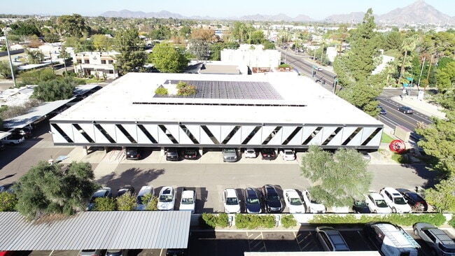


Property Detail
4450 N 12Th St
155-14-039
MEADOWBROOK TRACT BLK 1 MCR 7-09
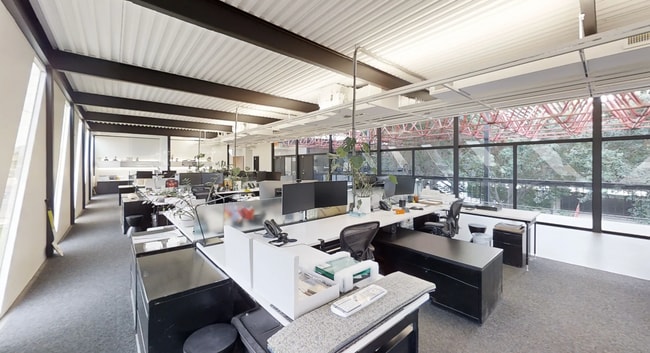
Officebuilding
Maricopa
M-H
Arizona
A Areas with a 1% annual chance of flooding and a 26% chance of flooding over the life of a 30-year mortgage.
1
2025
0.37 AC
2025
Midtown/Central Phoenix
108602
Phoenix
24,025 SF
Phoenix-Mesa-Chandler, AZ
NEARBY LISTINGS FOR SALE OR LEASE
DEMOGRAPHICS near 4450 N 12Th St
1 mile
3 mile
5 mile
2025 Total Population
20,524
167,851
424,842
2030 Population
21,520
175,652
443,400
Pop Growth 2025-2030
+ 4.85%
+ 4.65%
+ 4.37%
Average Age
37
39
37
2025 Total Households
10,528
78,952
173,781
HH Growth 2025-2030
+ 4.78%
+ 4.81%
+ 4.66%
Median Household Inc
$65,982
$76,399
$69,080
Avg Household Size
1.90
2.10
2.30
2025 Avg HH Vehicles
1.00
2.00
2.00
Median Home Value
$475,343
$595,323
$519,606
Median Year Built
1978
1970
1972
Nearby Places
Map Layers
Map Styles
 Street
 Aerial
Layers
 Traffic
 Biking
Places
Listings with unknown addresses are not visible on the map
- Restaurants
- Banks
- Shops
- Fitness
- Groceries
PUBLIC TRANSPORTATION
AIRPORT
Phoenix Sky Harbor International
Drive
Walk
Distance
Phoenix Sky Harbor International
14 min
7.6 mi
Phoenix-Mesa Gateway
Drive
Walk
Distance
Phoenix-Mesa Gateway
48 min
34.8 mi
SALE & LEASE HISTORY
LISTING DATE
SALE/LEASE

Oct 06, 2017
For Lease
Nov 16, 2017
For Lease
Mar 18, 2025
For Sale
Mar 13, 2024
For Lease
Jan 26, 2023
For Lease
Nearby Properties
Address
Land Use
TOTAL SIZE
Lot Size
Zoning
Address
Land Use
TOTAL SIZE
Lot Size
Zoning
582,073 SF
1.45 AC
C-C
Address
Land Use
TOTAL SIZE
Lot Size
Zoning
1.85 AC
Address
Land Use
TOTAL SIZE
Lot Size
Zoning
455,443 SF
3.21 AC
C-C
Address
Land Use
TOTAL SIZE
Lot Size
Zoning
339,909 SF
3 AC
C-C
Address
Land Use
TOTAL SIZE
Lot Size
Zoning
2,568,761 SF
48.36 AC
C-C
Address
Land Use
TOTAL SIZE
Lot Size
Zoning
437,102 SF
1.02 AC
C-2
Address
Land Use
TOTAL SIZE
Lot Size
Zoning
2,006,402 SF
18.66 AC
C-C
Address
Land Use
TOTAL SIZE
Lot Size
Zoning
2,334,671 SF
32.63 AC
C-2
Address
Land Use
TOTAL SIZE
Lot Size
Zoning
191,120 SF
1.43 AC
C-C
Address
Land Use
TOTAL SIZE
Lot Size
Zoning
71,306 SF
8.93 AC
M-H
Address
Land Use
TOTAL SIZE
Lot Size
Zoning
63,018 SF
4.77 AC
C-T
Address
Land Use
TOTAL SIZE
Lot Size
Zoning
969,844 SF
27.97 AC
PAD
Address
Land Use
TOTAL SIZE
Lot Size
Zoning
913,637 SF
35.53 AC
M-H
Address
Land Use
TOTAL SIZE
Lot Size
Zoning
686,094 SF
5.09 AC
C-C
Address
Land Use
TOTAL SIZE
Lot Size
Zoning
953,192 SF
28.99 AC
Address
Land Use
TOTAL SIZE
Lot Size
Zoning
50,161 SF
2.05 AC
M-H
Address
Land Use
TOTAL SIZE
Lot Size
Zoning
860,020 SF
5.89 AC
C2
Address
Land Use
TOTAL SIZE
Lot Size
Zoning
21,587 SF
3.66 AC
R-10
Address
Land Use
TOTAL SIZE
Lot Size
Zoning
410,000 SF
1.86 AC
C-C
Address
Land Use
TOTAL SIZE
Lot Size
Zoning
547,141 SF
18.52 AC
R-6
Address
Land Use
TOTAL SIZE
Lot Size
Zoning
386,004 SF
37.82 AC
R-6
Address
Land Use
TOTAL SIZE
Lot Size
Zoning
812,968 SF
7.08 AC
Address
Land Use
TOTAL SIZE
Lot Size
Zoning
517,609 SF
1.67 AC
C-C
Address
Land Use
TOTAL SIZE
Lot Size
Zoning
599,524 SF
5.09 AC
R5
Address
Land Use
TOTAL SIZE
Lot Size
Zoning
656,952 SF
3.58 AC
Address
Land Use
TOTAL SIZE
Lot Size
Zoning
184,363 SF
1.24 AC
WU
Address
Land Use
TOTAL SIZE
Lot Size
Zoning
496,222 SF
29.53 AC
C-R
Address
Land Use
TOTAL SIZE
Lot Size
Zoning
23,462 SF
1.91 AC
C-C
Address
Land Use
TOTAL SIZE
Lot Size
Zoning
567,481 SF
2 AC
Address
Land Use
TOTAL SIZE
Lot Size
Zoning
729,101 SF
4.31 AC
C-2
The World's #1 Commercial Real Estate Marketplace
Connect with us
© 2026 CoStar Group
The information above has been obtained from sources believed reliable. While we do not doubt its accuracy we have not verified it and make no guarantee, warranty or representation about it. It is your responsibility to independently confirm its accuracy and completeness. Any projections, opinions, assumptions, or estimates used are for example only and do not represent the current or future performance of the property. The value of this transaction to you depends on tax and other factors which should be evaluated by your tax, financial, and legal advisors. You and your advisors should conduct a careful, independent investigation of the property to determine to your satisfaction the suitability of the property for your needs.