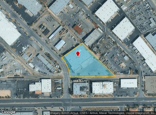
Property Record
4450 N Walnut Rd, North Las Vegas, NV 89081
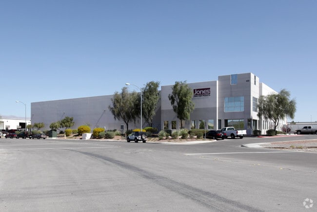
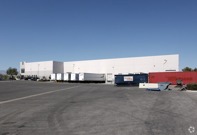

This Property Is For Sale
Current Lease Availabilities
NEARBY LISTINGS FOR SALE OR LEASE
Property Detail
4450 N Walnut Rd
Las Vegas-Henderson-Paradise, NV
Nellis Indst Park Unit #1
140-06-610-007
NELLIS INDST PARK UNIT #1 PLAT BOOK 10 PAGE 76 LOT 11 BLOCK 4
Shipyard
Clark
A
Nevada
32003C2177F
11
2025
3.47 AC
2025
North Las Vegas
006001
Las Vegas
56,260 SF
DEMOGRAPHICS near 4450 N Walnut Rd
1 Mile
3 Mile
5 Mile
2024 Total Population
11,668
116,753
337,591
2029 Population
12,358
125,078
362,318
Pop Growth 2024-2029
+ 5.91%
+ 7.13%
+ 7.32%
Average Age
33
33
34
2024 Total Households
3,354
35,499
102,997
HH Growth 2024-2029
+ 5.87%
+ 7.06%
+ 7.34%
Median Household Inc
$52,116
$51,684
$51,932
Avg Household Size
3.40
3.20
3.10
2024 Avg HH Vehicles
2.00
2.00
2.00
Median Home Value
$259,985
$287,415
$278,514
Median Year Built
1993
1998
1995
Nearby Places
Map Layers
Map Styles
 Street
 Aerial
- Restaurants
- Banks
- Shops
- Fitness
- Groceries
PUBLIC TRANSPORTATION
AIRPORT
Harry Reid International
DRIVE
WALK
Distance
Harry Reid International
23 min
14.8 mi
Boulder City Municipal
DRIVE
WALK
Distance
Boulder City Municipal
43 min
29.5 mi
Nearby Properties
Address
Land Use
TOTAL SIZE
Lot Size
Zoning
Address
Land Use
TOTAL SIZE
Lot Size
Zoning
1,767,948 SF
142.04 AC
Address
Land Use
TOTAL SIZE
Lot Size
Zoning
252,005 SF
27.94 AC
C3
Address
Land Use
TOTAL SIZE
Lot Size
Zoning
1,102,891 SF
84.43 AC
Address
Land Use
TOTAL SIZE
Lot Size
Zoning
798,660 SF
37.86 AC
M2
Address
Land Use
TOTAL SIZE
Lot Size
Zoning
813,120 SF
38.20 AC
Address
Land Use
TOTAL SIZE
Lot Size
Zoning
656,250 SF
29.11 AC
Address
Land Use
TOTAL SIZE
Lot Size
Zoning
51.45 AC
R1
Address
Land Use
TOTAL SIZE
Lot Size
Zoning
747,196 SF
40.03 AC
Address
Land Use
TOTAL SIZE
Lot Size
Zoning
632,224 SF
31.23 AC
Address
Land Use
TOTAL SIZE
Lot Size
Zoning
681,792 SF
29.65 AC
Address
Land Use
TOTAL SIZE
Lot Size
Zoning
621,824 SF
32.27 AC
Address
Land Use
TOTAL SIZE
Lot Size
Zoning
677,768 SF
31.52 AC
Address
Land Use
TOTAL SIZE
Lot Size
Zoning
696,064 SF
29.08 AC
Address
Land Use
TOTAL SIZE
Lot Size
Zoning
15,566 SF
48.39 AC
R4
Address
Land Use
TOTAL SIZE
Lot Size
Zoning
602,609 SF
27.33 AC
M2
Address
Land Use
TOTAL SIZE
Lot Size
Zoning
570,810 SF
29.73 AC
Address
Land Use
TOTAL SIZE
Lot Size
Zoning
625,804 SF
27.23 AC
Address
Land Use
TOTAL SIZE
Lot Size
Zoning
617,670 SF
27.90 AC
M2
Address
Land Use
TOTAL SIZE
Lot Size
Zoning
720,000 SF
25.07 AC
Address
Land Use
TOTAL SIZE
Lot Size
Zoning
3,735 SF
17.69 AC
R3
Address
Land Use
TOTAL SIZE
Lot Size
Zoning
35.49 AC
RE
Address
Land Use
TOTAL SIZE
Lot Size
Zoning
546,249 SF
28.58 AC
Address
Land Use
TOTAL SIZE
Lot Size
Zoning
152,520 SF
42.31 AC
M2
Address
Land Use
TOTAL SIZE
Lot Size
Zoning
400,162 SF
26.77 AC
Address
Land Use
TOTAL SIZE
Lot Size
Zoning
463,680 SF
13.81 AC
Address
Land Use
TOTAL SIZE
Lot Size
Zoning
18.08 AC
PSP
Address
Land Use
TOTAL SIZE
Lot Size
Zoning
376,264 SF
19 AC
Address
Land Use
TOTAL SIZE
Lot Size
Zoning
504,501 SF
23.08 AC
M2
Address
Land Use
TOTAL SIZE
Lot Size
Zoning
17.69 AC
RE
The World's #1 Commercial Real Estate Marketplace
Connect with us
© 2025 CoStar Group
The information above has been obtained from sources believed reliable. While we do not doubt its accuracy we have not verified it and make no guarantee, warranty or representation about it. It is your responsibility to independently confirm its accuracy and completeness. Any projections, opinions, assumptions, or estimates used are for example only and do not represent the current or future performance of the property. The value of this transaction to you depends on tax and other factors which should be evaluated by your tax, financial, and legal advisors. You and your advisors should conduct a careful, independent investigation of the property to determine to your satisfaction the suitability of the property for your needs.