Property Record
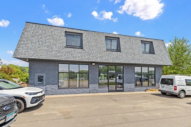
4466 Centerville Rd, Saint Paul, MN 55127


Save to a Folder
{{folder.Name}}
{{folder.ListingIds.length}} Properties
{{folder.ListingIds.length}} Property
Create a New Folder
This Property Is For Sale
Property Detail
4466 Centerville Rd
21-30-22-12-0021
SECTION 21 TOWN 30 RANGE 22 SEC 21 TN 30 RN 22 N 92.71 FT OF W 173 FT ...TO RD) IN SEC 21 TN 30 RN 22
Commercialnec
RAMSEY
B and X Area of moderate flood hazard, usually the area between the limits of the 100-year and 500-year floods.
Minnesota
2025
0.22 AC
2025
Rosedale
040503
Minneapolis/St Paul
5,232 SF
Minneapolis-St. Paul-Bloomington, MN-WI
NEARBY LISTINGS FOR SALE OR LEASE
DEMOGRAPHICS near 4466 Centerville Rd
1 mile
3 mile
5 mile
2025 Total Population
6,880
42,768
121,480
2030 Population
6,846
42,752
121,782
Pop Growth 2025-2030
(0.49%)
(0.04%)
+ 0.25%
Average Age
46
44
43
2025 Total Households
3,195
17,617
48,934
HH Growth 2025-2030
(0.72%)
(0.22%)
+ 0.09%
Median Household Inc
$91,128
$94,696
$96,748
Avg Household Size
2.10
2.40
2.40
2025 Avg HH Vehicles
2.00
2.00
2.00
Median Home Value
$363,724
$359,335
$366,366
Median Year Built
1985
1981
1980
Nearby Places
Map Layers
Map Styles
 Street
 Aerial
Layers
 Traffic
 Biking
Places
Listings with unknown addresses are not visible on the map
- Restaurants
- Banks
- Shops
- Fitness
- Groceries
PUBLIC TRANSPORTATION
AIRPORT
Minneapolis-St Paul International/Wold-Chamberlain
Drive
Walk
Distance
Minneapolis-St Paul International/Wold-Chamberlain
36 min
20.3 mi
Nearby Properties
Address
Land Use
TOTAL SIZE
Lot Size
Zoning
Address
Land Use
TOTAL SIZE
Lot Size
Zoning
5.59 AC
Address
Land Use
TOTAL SIZE
Lot Size
Zoning
13.44 AC
Address
Land Use
TOTAL SIZE
Lot Size
Zoning
250,050 SF
2.99 AC
Address
Land Use
TOTAL SIZE
Lot Size
Zoning
106,400 SF
18.29 AC
Address
Land Use
TOTAL SIZE
Lot Size
Zoning
78,163 SF
5.62 AC
Address
Land Use
TOTAL SIZE
Lot Size
Zoning
159.37 AC
Address
Land Use
TOTAL SIZE
Lot Size
Zoning
1,500 SF
25.38 AC
Address
Land Use
TOTAL SIZE
Lot Size
Zoning
211,420 SF
5.22 AC
Address
Land Use
TOTAL SIZE
Lot Size
Zoning
126,852 SF
11.86 AC
Address
Land Use
TOTAL SIZE
Lot Size
Zoning
67,693 SF
7.30 AC
Address
Land Use
TOTAL SIZE
Lot Size
Zoning
960 SF
17.11 AC
Address
Land Use
TOTAL SIZE
Lot Size
Zoning
138,655 SF
4.70 AC
Address
Land Use
TOTAL SIZE
Lot Size
Zoning
13,358 SF
311.47 AC
W8OPSP
Address
Land Use
TOTAL SIZE
Lot Size
Zoning
3,200 SF
14.31 AC
W7PUBLC
Address
Land Use
TOTAL SIZE
Lot Size
Zoning
26,109 SF
167.19 AC
Address
Land Use
TOTAL SIZE
Lot Size
Zoning
163,709 SF
1.22 AC
Address
Land Use
TOTAL SIZE
Lot Size
Zoning
295,860 SF
11.84 AC
Address
Land Use
TOTAL SIZE
Lot Size
Zoning
Address
Land Use
TOTAL SIZE
Lot Size
Zoning
204,399 SF
12.82 AC
Address
Land Use
TOTAL SIZE
Lot Size
Zoning
202,460 SF
26.72 AC
Address
Land Use
TOTAL SIZE
Lot Size
Zoning
156,090 SF
4.27 AC
Address
Land Use
TOTAL SIZE
Lot Size
Zoning
239.49 AC
Address
Land Use
TOTAL SIZE
Lot Size
Zoning
1,357 SF
8.22 AC
Address
Land Use
TOTAL SIZE
Lot Size
Zoning
88,787 SF
5.16 AC
Address
Land Use
TOTAL SIZE
Lot Size
Zoning
134,280 SF
4 AC
Address
Land Use
TOTAL SIZE
Lot Size
Zoning
234,156 SF
12.01 AC
Address
Land Use
TOTAL SIZE
Lot Size
Zoning
82,403 SF
41.35 AC
Address
Land Use
TOTAL SIZE
Lot Size
Zoning
128,462 SF
2.07 AC
Address
Land Use
TOTAL SIZE
Lot Size
Zoning
156,559 SF
18.55 AC
Address
Land Use
TOTAL SIZE
Lot Size
Zoning
132,487 SF
2.19 AC
The World's #1 Commercial Real Estate Marketplace
Connect with us
© 2026 CoStar Group
The information above has been obtained from sources believed reliable. While we do not doubt its accuracy we have not verified it and make no guarantee, warranty or representation about it. It is your responsibility to independently confirm its accuracy and completeness. Any projections, opinions, assumptions, or estimates used are for example only and do not represent the current or future performance of the property. The value of this transaction to you depends on tax and other factors which should be evaluated by your tax, financial, and legal advisors. You and your advisors should conduct a careful, independent investigation of the property to determine to your satisfaction the suitability of the property for your needs.