Property Record
448 Ventosa Way, Wells, NV 89835


Save to a Folder
{{folder.Name}}
{{folder.ListingIds.length}} Properties
{{folder.ListingIds.length}} Property
Create a New Folder
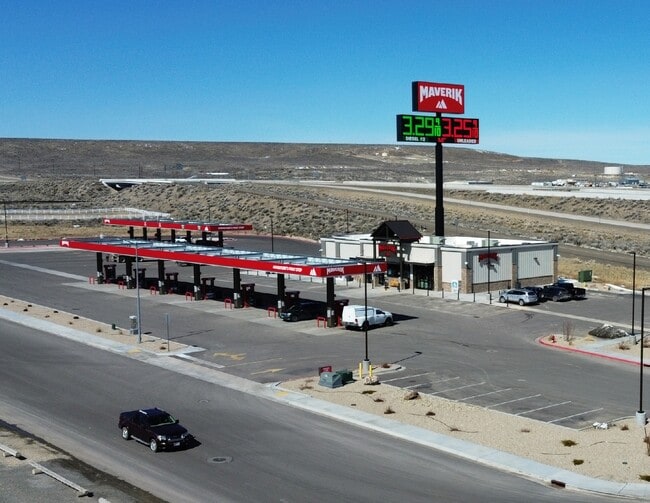
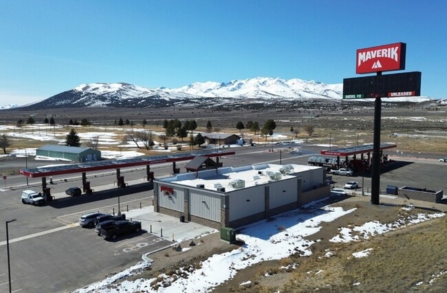
Property Detail
448 Ventosa Way
002-740-003
A PARCEL OF LAND LOCATED IN THE NE4SW4 OF,MDB&M DESCRIBED AS FOLLOWS:,BEG AT COR 1, FROM WHICH THE S1/4 COR OF SAID SEC,9 BEA
Commercialnec
ELKO
TC
Nevada
B and X Area of moderate flood hazard, usually the area between the limits of the 100-year and 500-year floods.
3.92 AC
2024
Carson City/Nevada Area
2025
Other Market Areas
950200
Elko, NV
6,123 SF
NEARBY LISTINGS FOR SALE OR LEASE
DEMOGRAPHICS near 448 Ventosa Way
1 mile
3 mile
5 mile
2025 Total Population
913
987
1,003
2030 Population
850
917
932
Pop Growth 2025-2030
(6.90%)
(7.09%)
(7.08%)
Average Age
41
41
41
2025 Total Households
361
385
390
HH Growth 2025-2030
(7.20%)
(7.27%)
(7.18%)
Median Household Inc
$85,714
$85,416
$85,321
Avg Household Size
2.40
2.40
2.40
2025 Avg HH Vehicles
2.00
2.00
2.00
Median Home Value
$211,290
$219,231
$219,697
Median Year Built
1979
1979
1979
Nearby Places
Map Layers
Map Styles
 Street
 Aerial
Layers
 Traffic
 Biking
Places
Listings with unknown addresses are not visible on the map
- Restaurants
- Banks
- Shops
- Fitness
- Groceries
SALE & LEASE HISTORY
LISTING DATE
SALE/LEASE

Apr 23, 2025
For Sale
Nearby Properties
Address
Land Use
TOTAL SIZE
Lot Size
Zoning
Address
Land Use
TOTAL SIZE
Lot Size
Zoning
55,394 SF
4.05 AC
TC
Address
Land Use
TOTAL SIZE
Lot Size
Zoning
21,251 SF
15.39 AC
TC
Address
Land Use
TOTAL SIZE
Lot Size
Zoning
11,032 SF
15.01 AC
TC
Address
Land Use
TOTAL SIZE
Lot Size
Zoning
24,868 SF
14.51 AC
TC
Address
Land Use
TOTAL SIZE
Lot Size
Zoning
34,006 SF
10.66 AC
P
Address
Land Use
TOTAL SIZE
Lot Size
Zoning
44,497 SF
3.76 AC
P
Address
Land Use
TOTAL SIZE
Lot Size
Zoning
24,400 SF
9.28 AC
MI-1
Address
Land Use
TOTAL SIZE
Lot Size
Zoning
8,400 SF
1.05 AC
R1
Address
Land Use
TOTAL SIZE
Lot Size
Zoning
3,572 SF
2.63 AC
TC
Address
Land Use
TOTAL SIZE
Lot Size
Zoning
17,480 SF
2.29 AC
TC
Address
Land Use
TOTAL SIZE
Lot Size
Zoning
21,698 SF
1.09 AC
TC
Address
Land Use
TOTAL SIZE
Lot Size
Zoning
10,556 SF
1.17 AC
R2-MH
Address
Land Use
TOTAL SIZE
Lot Size
Zoning
17,347 SF
5.01 AC
MI-2
Address
Land Use
TOTAL SIZE
Lot Size
Zoning
8,482 SF
0.59 AC
GC
Address
Land Use
TOTAL SIZE
Lot Size
Zoning
9,776.58 AC
Address
Land Use
TOTAL SIZE
Lot Size
Zoning
5,206 SF
1.06 AC
R1
Address
Land Use
TOTAL SIZE
Lot Size
Zoning
41,306 SF
2.85 AC
R1
Address
Land Use
TOTAL SIZE
Lot Size
Zoning
8,000 SF
0.63 AC
TC
Address
Land Use
TOTAL SIZE
Lot Size
Zoning
13,200 SF
18.69 AC
MI-2
Address
Land Use
TOTAL SIZE
Lot Size
Zoning
14,050 SF
2.72 AC
TC
Address
Land Use
TOTAL SIZE
Lot Size
Zoning
5,420 SF
1.36 AC
TC
Address
Land Use
TOTAL SIZE
Lot Size
Zoning
8,288 SF
6.55 AC
TC
Address
Land Use
TOTAL SIZE
Lot Size
Zoning
8,306 SF
711.32 AC
AP
Address
Land Use
TOTAL SIZE
Lot Size
Zoning
3,286 SF
69.25 AC
P
Address
Land Use
TOTAL SIZE
Lot Size
Zoning
17,461 SF
0.63 AC
TC
Address
Land Use
TOTAL SIZE
Lot Size
Zoning
3,536 SF
0.97 AC
TC
Address
Land Use
TOTAL SIZE
Lot Size
Zoning
7,651.88 AC
Address
Land Use
TOTAL SIZE
Lot Size
Zoning
32,750 SF
4 AC
MI-1
Address
Land Use
TOTAL SIZE
Lot Size
Zoning
9,396 SF
1.15 AC
TC
The World's #1 Commercial Real Estate Marketplace
Connect with us
© 2026 CoStar Group
The information above has been obtained from sources believed reliable. While we do not doubt its accuracy we have not verified it and make no guarantee, warranty or representation about it. It is your responsibility to independently confirm its accuracy and completeness. Any projections, opinions, assumptions, or estimates used are for example only and do not represent the current or future performance of the property. The value of this transaction to you depends on tax and other factors which should be evaluated by your tax, financial, and legal advisors. You and your advisors should conduct a careful, independent investigation of the property to determine to your satisfaction the suitability of the property for your needs.