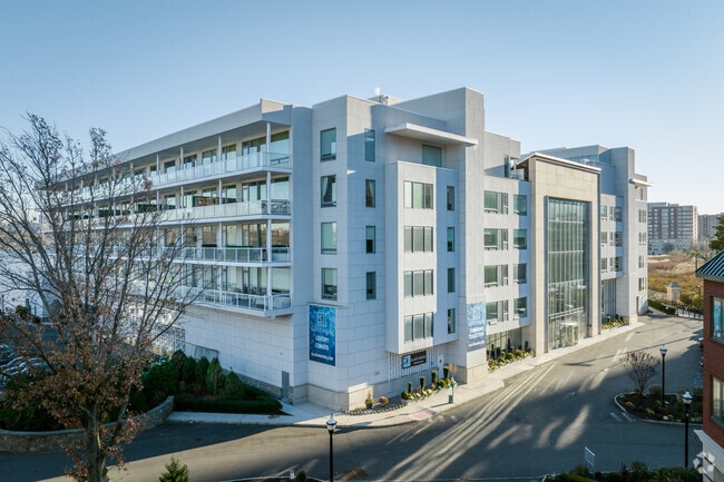
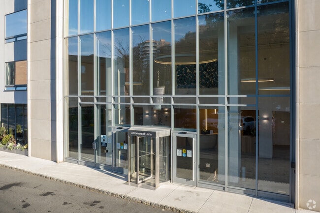
Property Record
45 Condo Rd, Edgewater, NJ 07020
NEARBY LISTINGS FOR SALE OR LEASE
Property Detail
45 Condo Rd
13-00099-0000-00001-15
2.2
Taxexempt
Bergen
AE
New Jersey
34003C0286H
3
0
Bergen County Waterfront
2025
Northern New Jersey
013004
New York-Jersey City-White Plains, NY-NJ
DEMOGRAPHICS near 45 Condo Rd
1 Mile
3 Mile
5 Mile
2024 Total Population
50,871
915,002
2,207,644
2029 Population
48,842
853,030
2,071,985
Pop Growth 2024-2029
(3.99%)
(6.77%)
(6.14%)
Average Age
41
42
40
2024 Total Households
20,668
418,786
988,800
HH Growth 2024-2029
(4.16%)
(7.06%)
(6.48%)
Median Household Inc
$79,657
$84,692
$81,199
Avg Household Size
2.40
2.10
2.10
2024 Avg HH Vehicles
1.00
.00
.00
Median Home Value
$497,880
$883,215
$807,899
Median Year Built
1966
1957
1957
Nearby Places
Map Layers
Map Styles
 Street
 Aerial
- Restaurants
- Banks
- Shops
- Fitness
- Groceries
PUBLIC TRANSPORTATION
COMMUTER RAIL
Grand Central (Babylon Branch - Long Island Rail Road, Far Rockaway Branch - Long Island Rail Road, Hempstead Branch - Long Island Rail Road, Port Jefferson Branch - Long Island Rail Road, Port Washington Branch - Long Island Rail Road)
DRIVE
WALK
Distance
Grand Central (Babylon Branch - Long Island Rail Road, Far Rockaway Branch - Long Island Rail Road, Hempstead Branch - Long Island Rail Road, Port Jefferson Branch - Long Island Rail Road, Port Washington Branch - Long Island Rail Road)
17 min
7.3 mi
Harlem-125Th Street Station (Harlem Line - Metro-North Commuter Railroad Company (Metro-North), Hudson Line - Metro-North Commuter Railroad Company (Metro-North), New Haven Line - Metro-North Commuter Railroad Company (Metro-North))
DRIVE
WALK
Distance
Harlem-125Th Street Station (Harlem Line - Metro-North Commuter Railroad Company (Metro-North), Hudson Line - Metro-North Commuter Railroad Company (Metro-North), New Haven Line - Metro-North Commuter Railroad Company (Metro-North))
17 min
9.6 mi
AIRPORT
Newark Liberty International
DRIVE
WALK
Distance
Newark Liberty International
19 min
14.6 mi
LaGuardia
DRIVE
WALK
Distance
LaGuardia
28 min
15.4 mi
John F Kennedy International
DRIVE
WALK
Distance
John F Kennedy International
39 min
26.4 mi
Freight Ports
NY - Red Hook Container Terminal
DRIVE
WALK
Distance
NY - Red Hook Container Terminal
30 min
15.2 mi
Nearby Properties
Address
Land Use
TOTAL SIZE
Lot Size
Zoning
Address
Land Use
TOTAL SIZE
Lot Size
Zoning
1,783,434 SF
1.94 AC
C5-3
Address
Land Use
TOTAL SIZE
Lot Size
Zoning
1,897,491 SF
2.06 AC
C52.5
Address
Land Use
TOTAL SIZE
Lot Size
Zoning
1,233,684 SF
16.94 AC
PARK
Address
Land Use
TOTAL SIZE
Lot Size
Zoning
1,638,259 SF
1.43 AC
C52.5
Address
Land Use
TOTAL SIZE
Lot Size
Zoning
2,360,627 SF
2.08 AC
C6-7
Address
Land Use
TOTAL SIZE
Lot Size
Zoning
1,962,900 SF
1.89 AC
C66.5
Address
Land Use
TOTAL SIZE
Lot Size
Zoning
1,842,991 SF
2.08 AC
C66.5
Address
Land Use
TOTAL SIZE
Lot Size
Zoning
400,160 SF
10.96 AC
R7-2
Address
Land Use
TOTAL SIZE
Lot Size
Zoning
1,613,847 SF
1.84 AC
C66.5
Address
Land Use
TOTAL SIZE
Lot Size
Zoning
2,215,000 SF
6.43 AC
R9
Address
Land Use
TOTAL SIZE
Lot Size
Zoning
1,596,521 SF
1.34 AC
C6-4
Address
Land Use
TOTAL SIZE
Lot Size
Zoning
264,420 SF
7.26 AC
C4-7
Address
Land Use
TOTAL SIZE
Lot Size
Zoning
1,606,528 SF
1.84 AC
C6-6
Address
Land Use
TOTAL SIZE
Lot Size
Zoning
1,482,208 SF
1.71 AC
C5-3
Address
Land Use
TOTAL SIZE
Lot Size
Zoning
637,863 SF
C6-6
Address
Land Use
TOTAL SIZE
Lot Size
Zoning
174 AC
P2
Address
Land Use
TOTAL SIZE
Lot Size
Zoning
685,125 SF
0.85 AC
C5-3
Address
Land Use
TOTAL SIZE
Lot Size
Zoning
1,793,328 SF
3.69 AC
C6-4
Address
Land Use
TOTAL SIZE
Lot Size
Zoning
26.93 AC
R8
Address
Land Use
TOTAL SIZE
Lot Size
Zoning
843,564 SF
1.07 AC
C6-4
Address
Land Use
TOTAL SIZE
Lot Size
Zoning
986,246 SF
0.90 AC
C5-3
Address
Land Use
TOTAL SIZE
Lot Size
Zoning
1,368,870 SF
16.86 AC
R8
Address
Land Use
TOTAL SIZE
Lot Size
Zoning
2,278,432 SF
5.99 AC
R7-2
Address
Land Use
TOTAL SIZE
Lot Size
Zoning
1,338,131 SF
2.10 AC
C66.5
Address
Land Use
TOTAL SIZE
Lot Size
Zoning
555 SF
4.89 AC
H
Address
Land Use
TOTAL SIZE
Lot Size
Zoning
1,020,000 SF
1.43 AC
C67T
Address
Land Use
TOTAL SIZE
Lot Size
Zoning
449,876 SF
0.81 AC
C5-3
Address
Land Use
TOTAL SIZE
Lot Size
Zoning
449,876 SF
0.81 AC
C5-3
Address
Land Use
TOTAL SIZE
Lot Size
Zoning
1,112,096 SF
1.97 AC
C4-7
Address
Land Use
TOTAL SIZE
Lot Size
Zoning
1,025,320 SF
4.47 AC
C4-7
The World's #1 Commercial Real Estate Marketplace
Connect with us
© 2025 CoStar Group
The information above has been obtained from sources believed reliable. While we do not doubt its accuracy we have not verified it and make no guarantee, warranty or representation about it. It is your responsibility to independently confirm its accuracy and completeness. Any projections, opinions, assumptions, or estimates used are for example only and do not represent the current or future performance of the property. The value of this transaction to you depends on tax and other factors which should be evaluated by your tax, financial, and legal advisors. You and your advisors should conduct a careful, independent investigation of the property to determine to your satisfaction the suitability of the property for your needs.