Property Record
450 Commerce Dr, Quakertown, PA 18951
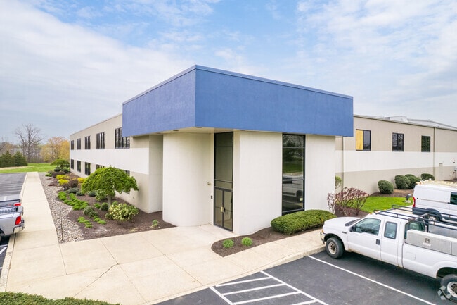

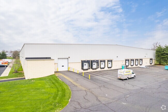
Property Detail
450 Commerce Dr
23-010-168
11.922AC LOT #8 MILFORD M ULTIPLEX/MILFORD BUS CTR 721 ON SR663
Warehouse
Bucks
PI
Pennsylvania
B and X Area of moderate flood hazard, usually the area between the limits of the 100-year and 500-year floods.
8
2024
11.92 AC
2025
Bucks
106402
Philadelphia
117,432 SF
Philadelphia-Camden-Wilmington, PA-NJ-DE-MD
NEARBY LISTINGS FOR SALE OR LEASE
-
-
-
-
No Photo
-
View all Quakertown listings for lease on LoopNet.com
DEMOGRAPHICS near 450 Commerce Dr
1 mile
3 mile
5 mile
2025 Total Population
2,677
28,006
45,754
2030 Population
2,698
28,060
46,153
Pop Growth 2025-2030
+ 0.78%
+ 0.19%
+ 0.87%
Average Age
44
42
43
2025 Total Households
1,002
10,672
17,330
HH Growth 2025-2030
+ 0.80%
+ 0.07%
+ 0.77%
Median Household Inc
$110,881
$90,880
$95,907
Avg Household Size
2.60
2.50
2.60
2025 Avg HH Vehicles
2.00
2.00
2.00
Median Home Value
$366,768
$351,665
$390,031
Median Year Built
1982
1980
1979
Nearby Places
Map Layers
Map Styles
 Street
 Aerial
Layers
 Traffic
 Biking
Places
Listings with unknown addresses are not visible on the map
- Restaurants
- Banks
- Shops
- Fitness
- Groceries
PUBLIC TRANSPORTATION
AIRPORT
Lehigh Valley International
Drive
Walk
Distance
Lehigh Valley International
34 min
18.4 mi
Trenton Mercer
Drive
Walk
Distance
Trenton Mercer
67 min
38.9 mi
SALE & LEASE HISTORY
LISTING DATE
SALE/LEASE

May 16, 2019
For Lease
May 03, 2019
For Lease
Jun 20, 2019
For Lease
Nearby Properties
Address
Land Use
TOTAL SIZE
Lot Size
Zoning
Address
Land Use
TOTAL SIZE
Lot Size
Zoning
935,540 SF
76.84 AC
RA
Address
Land Use
TOTAL SIZE
Lot Size
Zoning
276,132 SF
61.72 AC
PC
Address
Land Use
TOTAL SIZE
Lot Size
Zoning
51,884 SF
40.42 AC
EXT
Address
Land Use
TOTAL SIZE
Lot Size
Zoning
203,923 SF
34.17 AC
HC
Address
Land Use
TOTAL SIZE
Lot Size
Zoning
157,360 SF
17.34 AC
SRC
Address
Land Use
TOTAL SIZE
Lot Size
Zoning
145,197 SF
17.11 AC
PC
Address
Land Use
TOTAL SIZE
Lot Size
Zoning
248,895 SF
18.33 AC
I
Address
Land Use
TOTAL SIZE
Lot Size
Zoning
264,600 SF
33.38 AC
PI
Address
Land Use
TOTAL SIZE
Lot Size
Zoning
127,968 SF
15.38 AC
PC
Address
Land Use
TOTAL SIZE
Lot Size
Zoning
14,450 SF
7.16 AC
R4
Address
Land Use
TOTAL SIZE
Lot Size
Zoning
86,827 SF
11.84 AC
PC
Address
Land Use
TOTAL SIZE
Lot Size
Zoning
362,576 SF
25.24 AC
PI
Address
Land Use
TOTAL SIZE
Lot Size
Zoning
1 SF
15.66 AC
PC
Address
Land Use
TOTAL SIZE
Lot Size
Zoning
215,368 SF
24.49 AC
SRM
Address
Land Use
TOTAL SIZE
Lot Size
Zoning
208,937 SF
20.07 AC
PC
Address
Land Use
TOTAL SIZE
Lot Size
Zoning
145,800 SF
11.66 AC
P1
Address
Land Use
TOTAL SIZE
Lot Size
Zoning
67,443 SF
1.97 AC
NC
Address
Land Use
TOTAL SIZE
Lot Size
Zoning
58,391 SF
9.45 AC
PC
Address
Land Use
TOTAL SIZE
Lot Size
Zoning
7.98 AC
PI
Address
Land Use
TOTAL SIZE
Lot Size
Zoning
186,547 SF
18.74 AC
PI
Address
Land Use
TOTAL SIZE
Lot Size
Zoning
1,200 SF
17.50 AC
PI
Address
Land Use
TOTAL SIZE
Lot Size
Zoning
114,400 SF
9.96 AC
P1
Address
Land Use
TOTAL SIZE
Lot Size
Zoning
36,450 SF
3.09 AC
HC
Address
Land Use
TOTAL SIZE
Lot Size
Zoning
125,000 SF
19.58 AC
PI
Address
Land Use
TOTAL SIZE
Lot Size
Zoning
12,734 SF
4.68 AC
HC
Address
Land Use
TOTAL SIZE
Lot Size
Zoning
34,206 SF
11.49 AC
PC
Address
Land Use
TOTAL SIZE
Lot Size
Zoning
48,457 SF
2.73 AC
PC
Address
Land Use
TOTAL SIZE
Lot Size
Zoning
22,950 SF
1.97 AC
HR
Address
Land Use
TOTAL SIZE
Lot Size
Zoning
53,124 SF
3.37 AC
PC
The World's #1 Commercial Real Estate Marketplace
Connect with us
© 2026 CoStar Group
The information above has been obtained from sources believed reliable. While we do not doubt its accuracy we have not verified it and make no guarantee, warranty or representation about it. It is your responsibility to independently confirm its accuracy and completeness. Any projections, opinions, assumptions, or estimates used are for example only and do not represent the current or future performance of the property. The value of this transaction to you depends on tax and other factors which should be evaluated by your tax, financial, and legal advisors. You and your advisors should conduct a careful, independent investigation of the property to determine to your satisfaction the suitability of the property for your needs.