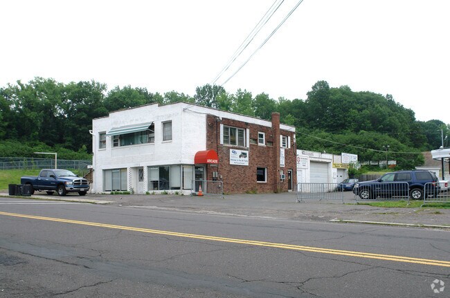
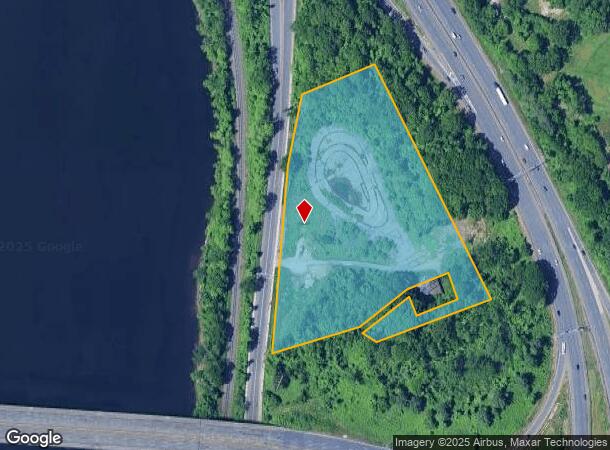
Property Record
451 Center St, Chicopee, MA 01013

NEARBY LISTINGS FOR SALE OR LEASE
Property Detail
451 Center St
CHIC-000026-000000-000004
Hampden
Taxexempt
Massachusetts
X
7.29 AC
25013C0213E
Hampden County
0
Hartford
2025
Springfield, MA
810902
DEMOGRAPHICS near 451 Center St
1 Mile
3 Mile
5 Mile
2024 Total Population
10,225
103,237
227,513
2029 Population
9,995
101,191
223,306
Pop Growth 2024-2029
(2.25%)
(1.98%)
(1.85%)
Average Age
38
39
39
2024 Total Households
4,421
42,772
90,465
HH Growth 2024-2029
(2.33%)
(2.01%)
(1.89%)
Median Household Inc
$53,376
$46,061
$47,007
Avg Household Size
2.20
2.30
2.40
2024 Avg HH Vehicles
1.00
1.00
1.00
Median Home Value
$225,673
$222,006
$226,924
Median Year Built
1947
1950
1951
Nearby Places
Map Layers
Map Styles
 Street
 Aerial
- Restaurants
- Banks
- Shops
- Fitness
- Groceries
PUBLIC TRANSPORTATION
COMMUTER RAIL
DRIVE
WALK
Distance
5 min
2.6 mi
DRIVE
WALK
Distance
8 min
5.1 mi
AIRPORT
Bradley International
DRIVE
WALK
Distance
Bradley International
32 min
15.4 mi
Nearby Properties
Address
Land Use
TOTAL SIZE
Lot Size
Zoning
Address
Land Use
TOTAL SIZE
Lot Size
Zoning
50.97 AC
BH
Address
Land Use
TOTAL SIZE
Lot Size
Zoning
209,471 SF
2.98 AC
SR3C1
Address
Land Use
TOTAL SIZE
Lot Size
Zoning
247,375 SF
19.52 AC
B2
Address
Land Use
TOTAL SIZE
Lot Size
Zoning
257,525 SF
64.03 AC
Address
Land Use
TOTAL SIZE
Lot Size
Zoning
48,924 SF
40.03 AC
I2
Address
Land Use
TOTAL SIZE
Lot Size
Zoning
21.80 AC
106
Address
Land Use
TOTAL SIZE
Lot Size
Zoning
141,970 SF
4.34 AC
S
Address
Land Use
TOTAL SIZE
Lot Size
Zoning
112,378 SF
3.03 AC
R2
Address
Land Use
TOTAL SIZE
Lot Size
Zoning
286,624 SF
17.40 AC
102
Address
Land Use
TOTAL SIZE
Lot Size
Zoning
261,176 SF
33.36 AC
Address
Land Use
TOTAL SIZE
Lot Size
Zoning
82,248 SF
4.57 AC
SR3C1
Address
Land Use
TOTAL SIZE
Lot Size
Zoning
227,072 SF
4.37 AC
B3
Address
Land Use
TOTAL SIZE
Lot Size
Zoning
24.55 AC
102
Address
Land Use
TOTAL SIZE
Lot Size
Zoning
219,521 SF
7.50 AC
R2
Address
Land Use
TOTAL SIZE
Lot Size
Zoning
839,347 SF
2.05 AC
B3
Address
Land Use
TOTAL SIZE
Lot Size
Zoning
200,000 SF
13.91 AC
R3
Address
Land Use
TOTAL SIZE
Lot Size
Zoning
29.88 AC
105
Address
Land Use
TOTAL SIZE
Lot Size
Zoning
115,600 SF
4.25 AC
B2
Address
Land Use
TOTAL SIZE
Lot Size
Zoning
24,835 SF
2.16 AC
B3
Address
Land Use
TOTAL SIZE
Lot Size
Zoning
36.60 AC
SR2C1
Address
Land Use
TOTAL SIZE
Lot Size
Zoning
189,022 SF
10.62 AC
RA
Address
Land Use
TOTAL SIZE
Lot Size
Zoning
201,800 SF
6.27 AC
R5
Address
Land Use
TOTAL SIZE
Lot Size
Zoning
335,105 SF
1.28 AC
B3
Address
Land Use
TOTAL SIZE
Lot Size
Zoning
186,700 SF
11.17 AC
SR3R5
Address
Land Use
TOTAL SIZE
Lot Size
Zoning
60,620 SF
4.96 AC
SR3B1
Address
Land Use
TOTAL SIZE
Lot Size
Zoning
217,116 SF
2.75 AC
R5
Address
Land Use
TOTAL SIZE
Lot Size
Zoning
77,012 SF
1.29 AC
B3
Address
Land Use
TOTAL SIZE
Lot Size
Zoning
102,787 SF
7.38 AC
I2
Address
Land Use
TOTAL SIZE
Lot Size
Zoning
138,504 SF
13.18 AC
RO
Address
Land Use
TOTAL SIZE
Lot Size
Zoning
128,877 SF
28.75 AC
The World's #1 Commercial Real Estate Marketplace
Connect with us
© 2026 CoStar Group
The information above has been obtained from sources believed reliable. While we do not doubt its accuracy we have not verified it and make no guarantee, warranty or representation about it. It is your responsibility to independently confirm its accuracy and completeness. Any projections, opinions, assumptions, or estimates used are for example only and do not represent the current or future performance of the property. The value of this transaction to you depends on tax and other factors which should be evaluated by your tax, financial, and legal advisors. You and your advisors should conduct a careful, independent investigation of the property to determine to your satisfaction the suitability of the property for your needs.