Property Record
4510 16Th Ave, Brooklyn, NY 11204
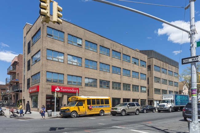

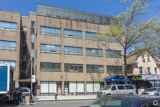

Property Detail
4510 16Th Ave
New York-Jersey City-White Plains, NY-NJ
DOCID-2022072000045001
05433-0040
KINGS
Funeralhome
New York
R6
40
2025
0.16 AC
2026
South Brooklyn
023200
Long Island (New York)
21,195 SF
NEARBY LISTINGS FOR SALE OR LEASE
DEMOGRAPHICS near 4510 16Th Ave
1 mile
3 mile
5 mile
2025 Total Population
169,766
1,100,680
2,121,490
2030 Population
166,072
1,079,697
2,094,272
Pop Growth 2025-2030
(2.18%)
(1.91%)
(1.28%)
Average Age
35
40
40
2025 Total Households
47,965
376,690
770,260
HH Growth 2025-2030
(2.40%)
(2.07%)
(1.46%)
Median Household Inc
$65,161
$78,920
$78,458
Avg Household Size
3.30
2.80
2.60
2025 Avg HH Vehicles
1.00
1.00
1.00
Median Home Value
$1,030,358
$997,366
$900,858
Median Year Built
1948
1947
1948
Nearby Places
Map Layers
Map Styles
 Street
 Aerial
Layers
 Traffic
 Biking
Places
Listings with unknown addresses are not visible on the map
- Restaurants
- Banks
- Shops
- Fitness
- Groceries
PUBLIC TRANSPORTATION
TRANSIT/SUBWAY
Ditmas Avenue (F - New York MTA Subway (The Subway))
Drive
Walk
Distance
Ditmas Avenue (F - New York MTA Subway (The Subway))
2 min
8 min
0.4 mi
18 Avenue (F Line) (F - New York MTA Subway (The Subway))
Drive
Walk
Distance
18 Avenue (F Line) (F - New York MTA Subway (The Subway))
2 min
9 min
0.5 mi
Avenue I (F - New York MTA Subway (The Subway))
Drive
Walk
Distance
Avenue I (F - New York MTA Subway (The Subway))
2 min
13 min
0.7 mi
50 Street (D,M Line) (D - New York MTA Subway (The Subway), M - New York MTA Subway (The Subway))
Drive
Walk
Distance
50 Street (D,M Line) (D - New York MTA Subway (The Subway), M - New York MTA Subway (The Subway))
3 min
16 min
0.8 mi
55 Street (D - New York MTA Subway (The Subway), M - New York MTA Subway (The Subway))
Drive
Walk
Distance
55 Street (D - New York MTA Subway (The Subway), M - New York MTA Subway (The Subway))
3 min
17 min
0.9 mi
COMMUTER RAIL
Nostrand Avenue Station (Far Rockaway Branch - Long Island Rail Road, Hempstead Branch - Long Island Rail Road, Long Beach Branch - Long Island Rail Road, West Hempstead Branch - Long Island Rail Road)
Drive
Walk
Distance
Nostrand Avenue Station (Far Rockaway Branch - Long Island Rail Road, Hempstead Branch - Long Island Rail Road, Long Beach Branch - Long Island Rail Road, West Hempstead Branch - Long Island Rail Road)
12 min
4.8 mi
Atlantic Terminal (Babylon Branch - Long Island Rail Road, City Terminal Zone - Long Island Rail Road, Hempstead Branch - Long Island Rail Road, West Hempstead Branch - Long Island Rail Road)
Drive
Walk
Distance
Atlantic Terminal (Babylon Branch - Long Island Rail Road, City Terminal Zone - Long Island Rail Road, Hempstead Branch - Long Island Rail Road, West Hempstead Branch - Long Island Rail Road)
12 min
4.8 mi
AIRPORT
John F Kennedy International
Drive
Walk
Distance
John F Kennedy International
25 min
13.6 mi
LaGuardia
Drive
Walk
Distance
LaGuardia
28 min
15.8 mi
Newark Liberty International
Drive
Walk
Distance
Newark Liberty International
33 min
19.3 mi
Freight Ports
NY - Red Hook Container Terminal
Drive
Walk
Distance
NY - Red Hook Container Terminal
9 min
4.7 mi
SALE & LEASE HISTORY
LISTING DATE
SALE/LEASE

Feb 08, 2017
For Lease
Aug 05, 2017
For Sale
Nearby Properties
Address
Land Use
TOTAL SIZE
Lot Size
Zoning
Address
Land Use
TOTAL SIZE
Lot Size
Zoning
92,440 SF
466.23 AC
R5
Address
Land Use
TOTAL SIZE
Lot Size
Zoning
1,503,150 SF
20.47 AC
R5
Address
Land Use
TOTAL SIZE
Lot Size
Zoning
393.54 AC
PARK
Address
Land Use
TOTAL SIZE
Lot Size
Zoning
1,524,659 SF
170.96 AC
R4
Address
Land Use
TOTAL SIZE
Lot Size
Zoning
577,381 SF
3.19 AC
R6
Address
Land Use
TOTAL SIZE
Lot Size
Zoning
902,000 SF
3.21 AC
M3-1
Address
Land Use
TOTAL SIZE
Lot Size
Zoning
965,600 SF
6.65 AC
R5
Address
Land Use
TOTAL SIZE
Lot Size
Zoning
1,061,228 SF
8.86 AC
R5
Address
Land Use
TOTAL SIZE
Lot Size
Zoning
460,000 SF
3.21 AC
R6
Address
Land Use
TOTAL SIZE
Lot Size
Zoning
1,073,920 SF
16.53 AC
R6
Address
Land Use
TOTAL SIZE
Lot Size
Zoning
561,945 SF
11.58 AC
R6
Address
Land Use
TOTAL SIZE
Lot Size
Zoning
335,800 SF
1.51 AC
R6
Address
Land Use
TOTAL SIZE
Lot Size
Zoning
785,450 SF
14.22 AC
R6
Address
Land Use
TOTAL SIZE
Lot Size
Zoning
1,324,592 SF
5.13 AC
M3-1
Address
Land Use
TOTAL SIZE
Lot Size
Zoning
397,354 SF
0.61 AC
C5-2
Address
Land Use
TOTAL SIZE
Lot Size
Zoning
566,000 SF
12.33 AC
R6
Address
Land Use
TOTAL SIZE
Lot Size
Zoning
473,345 SF
1.27 AC
R8X
Address
Land Use
TOTAL SIZE
Lot Size
Zoning
427,208 SF
1.30 AC
R6
Address
Land Use
TOTAL SIZE
Lot Size
Zoning
393,092 SF
1.07 AC
R8A
Address
Land Use
TOTAL SIZE
Lot Size
Zoning
371,139 SF
3.22 AC
R5
Address
Land Use
TOTAL SIZE
Lot Size
Zoning
5,359,400 SF
59.07 AC
M2-1
Address
Land Use
TOTAL SIZE
Lot Size
Zoning
286,000 SF
12.63 AC
PARK
Address
Land Use
TOTAL SIZE
Lot Size
Zoning
689,850 SF
3.08 AC
M3-1
Address
Land Use
TOTAL SIZE
Lot Size
Zoning
301,400 SF
22.27 AC
M3-1
Address
Land Use
TOTAL SIZE
Lot Size
Zoning
308,757 SF
0.74 AC
R7-1
Address
Land Use
TOTAL SIZE
Lot Size
Zoning
222,265 SF
0.74 AC
R6
Address
Land Use
TOTAL SIZE
Lot Size
Zoning
241,735 SF
1.99 AC
C8-4
Address
Land Use
TOTAL SIZE
Lot Size
Zoning
673,895 SF
3.22 AC
M3-1
Address
Land Use
TOTAL SIZE
Lot Size
Zoning
540,672 SF
10.65 AC
R6
Address
Land Use
TOTAL SIZE
Lot Size
Zoning
206,640 SF
3.21 AC
R6
The World's #1 Commercial Real Estate Marketplace
Connect with us
© 2026 CoStar Group
The information above has been obtained from sources believed reliable. While we do not doubt its accuracy we have not verified it and make no guarantee, warranty or representation about it. It is your responsibility to independently confirm its accuracy and completeness. Any projections, opinions, assumptions, or estimates used are for example only and do not represent the current or future performance of the property. The value of this transaction to you depends on tax and other factors which should be evaluated by your tax, financial, and legal advisors. You and your advisors should conduct a careful, independent investigation of the property to determine to your satisfaction the suitability of the property for your needs.