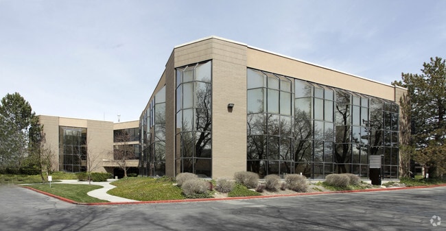
Property Record
4516 S 700 E, Salt Lake City, UT 84107

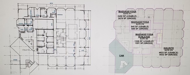
Current Lease Availabilities
NEARBY LISTINGS FOR SALE OR LEASE
Property Detail
4516 S 700 E
22-05-303-011-0000
Vega Park Plat No B-3
Officebuilding
BEG S 0^1050 E 279.2 FT & N 89^52 E 126.19 FT FR NW COR SW 1/4 SEC 5, T 2S, R 1E, S L M; SELY ALG A CURVE TO R 39.51 FT; S 0^2520 W 246.94 FT; S 89^4910 W 172.11 FT; N0^1050 W 71.49 FT; S 89^4910 W 225.55 FT; N 0^1050 W 202.2 FT; S 87^1748 E 24.06 FT
X
Salt Lake
49035C0311G
Utah
2024
2.12 AC
2025
Central Valley East
111905
Salt Lake City
49,143 SF
Salt Lake City-Murray, UT
DEMOGRAPHICS near 4516 S 700 E
1 Mile
3 Mile
5 Mile
2024 Total Population
20,864
146,187
365,422
2029 Population
21,052
147,741
369,158
Pop Growth 2024-2029
+ 0.90%
+ 1.06%
+ 1.02%
Average Age
40
38
38
2024 Total Households
9,215
59,002
142,741
HH Growth 2024-2029
+ 0.84%
+ 1.03%
+ 1.03%
Median Household Inc
$58,608
$67,504
$73,619
Avg Household Size
2.20
2.40
2.50
2024 Avg HH Vehicles
2.00
2.00
2.00
Median Home Value
$390,644
$462,864
$468,492
Median Year Built
1975
1976
1976
Nearby Places
Map Layers
Map Styles
 Street
 Aerial
- Restaurants
- Banks
- Shops
- Fitness
- Groceries
PUBLIC TRANSPORTATION
AIRPORT
Salt Lake City International
DRIVE
WALK
Distance
Salt Lake City International
19 min
13.1 mi
Provo Municipal
DRIVE
WALK
Distance
Provo Municipal
53 min
41.0 mi
Nearby Properties
Address
Land Use
TOTAL SIZE
Lot Size
Zoning
Address
Land Use
TOTAL SIZE
Lot Size
Zoning
2,024,859 SF
63 AC
C D C
Address
Land Use
TOTAL SIZE
Lot Size
Zoning
659,583 SF
18.32 AC
CDC
Address
Land Use
TOTAL SIZE
Lot Size
Zoning
488,509 SF
36.03 AC
FLEX
Address
Land Use
TOTAL SIZE
Lot Size
Zoning
207,140 SF
23.06 AC
P
Address
Land Use
TOTAL SIZE
Lot Size
Zoning
35,897 SF
28.61 AC
RM-12
Address
Land Use
TOTAL SIZE
Lot Size
Zoning
691,463 SF
17.80 AC
RM
Address
Land Use
TOTAL SIZE
Lot Size
Zoning
251,867 SF
25.66 AC
H
Address
Land Use
TOTAL SIZE
Lot Size
Zoning
524,108 SF
34.46 AC
RM
Address
Land Use
TOTAL SIZE
Lot Size
Zoning
521,964 SF
3.23 AC
T-O-D
Address
Land Use
TOTAL SIZE
Lot Size
Zoning
302,944 SF
5.47 AC
Address
Land Use
TOTAL SIZE
Lot Size
Zoning
369,717 SF
2.50 AC
RO
Address
Land Use
TOTAL SIZE
Lot Size
Zoning
412,006 SF
1.70 AC
C3
Address
Land Use
TOTAL SIZE
Lot Size
Zoning
179,702 SF
16.99 AC
1108
Address
Land Use
TOTAL SIZE
Lot Size
Zoning
95,854 SF
15.42 AC
CC
Address
Land Use
TOTAL SIZE
Lot Size
Zoning
21,057 SF
17.96 AC
RM20
Address
Land Use
TOTAL SIZE
Lot Size
Zoning
195,790 SF
14.32 AC
RM
Address
Land Use
TOTAL SIZE
Lot Size
Zoning
125,518 SF
11.03 AC
RMZC
Address
Land Use
TOTAL SIZE
Lot Size
Zoning
371,607 SF
10.77 AC
A-1
Address
Land Use
TOTAL SIZE
Lot Size
Zoning
33,164 SF
6.88 AC
RM
Address
Land Use
TOTAL SIZE
Lot Size
Zoning
37,563 SF
15.34 AC
RM20
Address
Land Use
TOTAL SIZE
Lot Size
Zoning
84,870 SF
9.76 AC
MPMU
Address
Land Use
TOTAL SIZE
Lot Size
Zoning
217,700 SF
52.59 AC
FLEX
Address
Land Use
TOTAL SIZE
Lot Size
Zoning
56,867 SF
5.33 AC
MIXED
Address
Land Use
TOTAL SIZE
Lot Size
Zoning
28,078 SF
15.33 AC
RM-10
Address
Land Use
TOTAL SIZE
Lot Size
Zoning
441,275 SF
2.62 AC
M-U
Address
Land Use
TOTAL SIZE
Lot Size
Zoning
138,180 SF
2.06 AC
RM-12
Address
Land Use
TOTAL SIZE
Lot Size
Zoning
80,985 SF
19.18 AC
RM
Address
Land Use
TOTAL SIZE
Lot Size
Zoning
299,673 SF
2.16 AC
C3
Address
Land Use
TOTAL SIZE
Lot Size
Zoning
137,697 SF
5.92 AC
C-2/ZC
Address
Land Use
TOTAL SIZE
Lot Size
Zoning
83,204 SF
12.87 AC
RM
The World's #1 Commercial Real Estate Marketplace
Connect with us
© 2026 CoStar Group
The information above has been obtained from sources believed reliable. While we do not doubt its accuracy we have not verified it and make no guarantee, warranty or representation about it. It is your responsibility to independently confirm its accuracy and completeness. Any projections, opinions, assumptions, or estimates used are for example only and do not represent the current or future performance of the property. The value of this transaction to you depends on tax and other factors which should be evaluated by your tax, financial, and legal advisors. You and your advisors should conduct a careful, independent investigation of the property to determine to your satisfaction the suitability of the property for your needs.