Property Record
4520 Saint Stephens Rd, Eight Mile, AL 36613
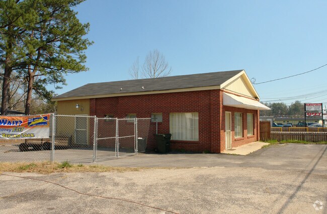


Property Detail
4520 Saint Stephens Rd
Mobile, AL
PART OF LOT 3 JOHN WARNER PROP MBK 4 PG 194 DESC AS FOLL BEG AT SW COR LOT 3 RUN NLY 91.6 FT TH SELY 80.8 FT TH SWLY 92.9 TH
23-06-36-0-002-078
Mobile
Officebuilding
Alabama
C and X Area of minimal flood hazard, usually depicted on FIRMs as above the 500-year flood level.
3
2025
0.12 AC
2025
Prichard/Saraland
006103
Mobile
1,131 SF
NEARBY LISTINGS FOR SALE OR LEASE
DEMOGRAPHICS near 4520 Saint Stephens Rd
1 mile
3 mile
5 mile
2024 Total Population
3,278
26,302
78,818
2029 Population
3,326
26,603
79,389
Pop Growth 2024-2029
+ 1.46%
+ 1.14%
+ 0.72%
Average Age
41
40
41
2024 Total Households
1,191
10,151
30,654
HH Growth 2024-2029
+ 1.43%
+ 1.15%
+ 0.81%
Median Household Inc
$45,631
$40,491
$43,962
Avg Household Size
2.60
2.50
2.40
2024 Avg HH Vehicles
2.00
2.00
2.00
Median Home Value
$92,892
$94,019
$131,221
Median Year Built
1977
1971
1970
Nearby Places
Map Layers
Map Styles
 Street
 Aerial
Transit
 Traffic
 Biking
Places
Listings with unknown addresses are not visible on the map
- Restaurants
- Banks
- Shops
- Fitness
- Groceries
PUBLIC TRANSPORTATION
AIRPORT
Mobile Regional
Drive
Walk
Distance
Mobile Regional
26 min
11.5 mi
Mobile International
Drive
Walk
Distance
Mobile International
20 min
13.8 mi
Freight Ports
Port of Mobile
Drive
Walk
Distance
Port of Mobile
12 min
8.6 mi
Nearby Properties
Address
Land Use
TOTAL SIZE
Lot Size
Zoning
Address
Land Use
TOTAL SIZE
Lot Size
Zoning
63,390 SF
107.45 AC
Address
Land Use
TOTAL SIZE
Lot Size
Zoning
35,775 SF
22.48 AC
Address
Land Use
TOTAL SIZE
Lot Size
Zoning
35,828 SF
26.30 AC
Address
Land Use
TOTAL SIZE
Lot Size
Zoning
187,257 SF
33.10 AC
Address
Land Use
TOTAL SIZE
Lot Size
Zoning
15,960 SF
11.06 AC
Address
Land Use
TOTAL SIZE
Lot Size
Zoning
5,553 SF
40.77 AC
Address
Land Use
TOTAL SIZE
Lot Size
Zoning
53,850 SF
12 AC
Address
Land Use
TOTAL SIZE
Lot Size
Zoning
45,980 SF
10.72 AC
Address
Land Use
TOTAL SIZE
Lot Size
Zoning
54,965 SF
1.97 AC
Address
Land Use
TOTAL SIZE
Lot Size
Zoning
87,532 SF
17 AC
Address
Land Use
TOTAL SIZE
Lot Size
Zoning
86,174 SF
9.30 AC
Address
Land Use
TOTAL SIZE
Lot Size
Zoning
94,787 SF
18 AC
Address
Land Use
TOTAL SIZE
Lot Size
Zoning
40,245 SF
1.99 AC
Address
Land Use
TOTAL SIZE
Lot Size
Zoning
48,304 SF
3.28 AC
Address
Land Use
TOTAL SIZE
Lot Size
Zoning
101,578 SF
32 AC
Address
Land Use
TOTAL SIZE
Lot Size
Zoning
89,556 SF
18 AC
Address
Land Use
TOTAL SIZE
Lot Size
Zoning
58,789 SF
17 AC
Address
Land Use
TOTAL SIZE
Lot Size
Zoning
58,624 SF
8.30 AC
Address
Land Use
TOTAL SIZE
Lot Size
Zoning
17,300 SF
7.17 AC
Address
Land Use
TOTAL SIZE
Lot Size
Zoning
17,422 SF
2.68 AC
Address
Land Use
TOTAL SIZE
Lot Size
Zoning
60,446 SF
2.67 AC
Address
Land Use
TOTAL SIZE
Lot Size
Zoning
40,755 SF
14 AC
Address
Land Use
TOTAL SIZE
Lot Size
Zoning
45,468 SF
3.91 AC
Address
Land Use
TOTAL SIZE
Lot Size
Zoning
44,368 SF
5.20 AC
Address
Land Use
TOTAL SIZE
Lot Size
Zoning
8,244 SF
8.47 AC
Address
Land Use
TOTAL SIZE
Lot Size
Zoning
46,492 SF
17 AC
Address
Land Use
TOTAL SIZE
Lot Size
Zoning
69,369 SF
6.60 AC
Address
Land Use
TOTAL SIZE
Lot Size
Zoning
40,757 SF
7.14 AC
Address
Land Use
TOTAL SIZE
Lot Size
Zoning
11,538 SF
4.84 AC
Address
Land Use
TOTAL SIZE
Lot Size
Zoning
196,257 SF
6.90 AC
The World's #1 Commercial Real Estate Marketplace
Connect with us
© 2026 CoStar Group
The information above has been obtained from sources believed reliable. While we do not doubt its accuracy we have not verified it and make no guarantee, warranty or representation about it. It is your responsibility to independently confirm its accuracy and completeness. Any projections, opinions, assumptions, or estimates used are for example only and do not represent the current or future performance of the property. The value of this transaction to you depends on tax and other factors which should be evaluated by your tax, financial, and legal advisors. You and your advisors should conduct a careful, independent investigation of the property to determine to your satisfaction the suitability of the property for your needs.