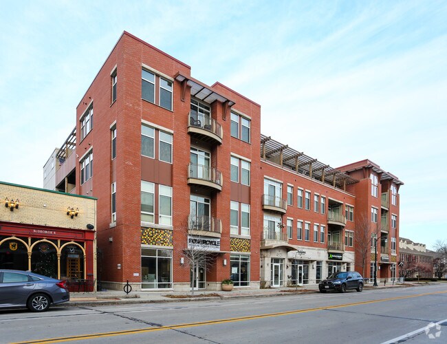
Property Record
4533 N Assessed Ave W, Shorewood, WI 53211

NEARBY LISTINGS FOR SALE OR LEASE
Property Detail
4533 N Assessed Ave W
Milwaukee-Waukesha-West Allis, WI
Glendale Inv Assn Subd
236-0168-000
GLENDALE INV ASSN SUBD #1 NE 1/4 4-7-22 E., S 9.11 FT OF LOT 1 & ALL OF 2 BLK 14 EXC E 7FT TAKEN FOR NORTH OAKLAND AVENUE
Commercialnec
Milwaukee
X
Wisconsin
55079C0082E
1
0
0.11 AC
2024
Shorewood/Whitefish Bay
007300
Milwaukee/Madison
DEMOGRAPHICS near 4533 N Assessed Ave W
1 Mile
3 Mile
5 Mile
2024 Total Population
15,537
104,872
265,714
2029 Population
14,987
102,988
262,372
Pop Growth 2024-2029
(3.54%)
(1.80%)
(1.26%)
Average Age
39
36
36
2024 Total Households
6,842
45,000
114,234
HH Growth 2024-2029
(3.60%)
(1.94%)
(1.32%)
Median Household Inc
$101,117
$52,369
$45,234
Avg Household Size
2.20
2.20
2.20
2024 Avg HH Vehicles
1.00
1.00
1.00
Median Home Value
$390,182
$269,883
$209,082
Median Year Built
1946
1947
1949
Nearby Places
Map Layers
Map Styles
 Street
 Aerial
- Restaurants
- Banks
- Shops
- Fitness
- Groceries
PUBLIC TRANSPORTATION
COMMUTER RAIL
Milwaukee (Empire Builder - Amtrak)
DRIVE
WALK
Distance
Milwaukee (Empire Builder - Amtrak)
12 min
4.5 mi
AIRPORT
General Mitchell International
DRIVE
WALK
Distance
General Mitchell International
24 min
12.1 mi
Freight Ports
Port Milwaukee
DRIVE
WALK
Distance
Port Milwaukee
17 min
7.9 mi
Nearby Properties
Address
Land Use
TOTAL SIZE
Lot Size
Zoning
Address
Land Use
TOTAL SIZE
Lot Size
Zoning
1,140,196 SF
5.33 AC
C9F(A)
Address
Land Use
TOTAL SIZE
Lot Size
Zoning
730,000 SF
6.94 AC
PD
Address
Land Use
TOTAL SIZE
Lot Size
Zoning
237,850 SF
5.02 AC
RM7
Address
Land Use
TOTAL SIZE
Lot Size
Zoning
380,817 SF
0.82 AC
C9F(A)
Address
Land Use
TOTAL SIZE
Lot Size
Zoning
495,212 SF
0.48 AC
C9F(A)
Address
Land Use
TOTAL SIZE
Lot Size
Zoning
26.11 AC
TL
Address
Land Use
TOTAL SIZE
Lot Size
Zoning
280,000 SF
2.74 AC
RED
Address
Land Use
TOTAL SIZE
Lot Size
Zoning
417,704 SF
0.81 AC
PD
Address
Land Use
TOTAL SIZE
Lot Size
Zoning
378,717 SF
0.61 AC
C9D(A)
Address
Land Use
TOTAL SIZE
Lot Size
Zoning
535,904 SF
3.88 AC
C9A(A)
Address
Land Use
TOTAL SIZE
Lot Size
Zoning
272,475 SF
0.66 AC
PD
Address
Land Use
TOTAL SIZE
Lot Size
Zoning
300,416 SF
1.24 AC
PD
Address
Land Use
TOTAL SIZE
Lot Size
Zoning
4.53 AC
C9F(A)
Address
Land Use
TOTAL SIZE
Lot Size
Zoning
382,921 SF
2.81 AC
PD
Address
Land Use
TOTAL SIZE
Lot Size
Zoning
425,000 SF
1.42 AC
C9F(A)
Address
Land Use
TOTAL SIZE
Lot Size
Zoning
180,407 SF
0.63 AC
PD
Address
Land Use
TOTAL SIZE
Lot Size
Zoning
534,786 SF
1.81 AC
C9D(A)
Address
Land Use
TOTAL SIZE
Lot Size
Zoning
210,552 SF
2.43 AC
C9D(A)
Address
Land Use
TOTAL SIZE
Lot Size
Zoning
42.90 AC
TL
Address
Land Use
TOTAL SIZE
Lot Size
Zoning
508,168 SF
14.56 AC
C9G
Address
Land Use
TOTAL SIZE
Lot Size
Zoning
391,430 SF
0.99 AC
C9F(B)
Address
Land Use
TOTAL SIZE
Lot Size
Zoning
162,000 SF
0.83 AC
PD
Address
Land Use
TOTAL SIZE
Lot Size
Zoning
66,245 SF
10.21 AC
Address
Land Use
TOTAL SIZE
Lot Size
Zoning
216,500 SF
0.03 AC
C9F(A)
Address
Land Use
TOTAL SIZE
Lot Size
Zoning
0.09 AC
LB2
Address
Land Use
TOTAL SIZE
Lot Size
Zoning
12.97 AC
TL
Address
Land Use
TOTAL SIZE
Lot Size
Zoning
85,000 SF
1.13 AC
Address
Land Use
TOTAL SIZE
Lot Size
Zoning
322,007 SF
1.25 AC
C9F(A)
Address
Land Use
TOTAL SIZE
Lot Size
Zoning
230,281 SF
1.79 AC
C9A(A)
Address
Land Use
TOTAL SIZE
Lot Size
Zoning
247,344 SF
1.44 AC
RED
The World's #1 Commercial Real Estate Marketplace
Connect with us
© 2025 CoStar Group
The information above has been obtained from sources believed reliable. While we do not doubt its accuracy we have not verified it and make no guarantee, warranty or representation about it. It is your responsibility to independently confirm its accuracy and completeness. Any projections, opinions, assumptions, or estimates used are for example only and do not represent the current or future performance of the property. The value of this transaction to you depends on tax and other factors which should be evaluated by your tax, financial, and legal advisors. You and your advisors should conduct a careful, independent investigation of the property to determine to your satisfaction the suitability of the property for your needs.