Property Record
4550 Leetsdale Dr, Denver, CO 80246


NEARBY LISTINGS FOR SALE OR LEASE
Property Detail
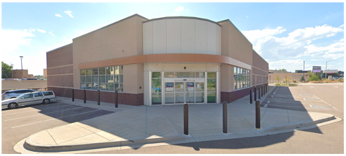
4550 Leetsdale Dr
Denver-Aurora-Centennial, CO
Corrected Block H Jersey Sub Replat
1973-18-2-20-001
TOWNSHIP T4S MAPPLATB 478 MAPPLATP 36 SUBDIVISIONCD 036751 SUBDIVISIONNAME CORRECTED BLOCK H JERSEY SUB REPLAT LOT 001 LOT 1 CORRECTED BLOCK H JERSEY SUB REPLAT
Storebuilding
Arapahoe
X
Colorado
0800460208H
1
2024
1.43 AC
2025
Colorado Bl/Cherry Ck
004952
Denver
11,806 SF
DEMOGRAPHICS near 4550 Leetsdale Dr
1 mile
3 mile
5 mile
2024 Total Population
23,340
214,407
544,426
2029 Population
23,801
217,344
551,964
Pop Growth 2024-2029
+ 1.98%
+ 1.37%
+ 1.38%
Average Age
41
40
38
2024 Total Households
12,737
108,380
256,092
HH Growth 2024-2029
+ 2.12%
+ 1.29%
+ 1.43%
Median Household Inc
$88,428
$84,953
$79,069
Avg Household Size
1.80
1.90
2.00
2024 Avg HH Vehicles
1.00
1.00
1.00
Median Home Value
$947,596
$739,286
$632,637
Median Year Built
1984
1968
1974
Nearby Places
Map Layers
Map Styles
 Street
 Aerial
Transit
 Traffic
 Biking
Places
Listings with unknown addresses are not visible on the map
- Restaurants
- Banks
- Shops
- Fitness
- Groceries
PUBLIC TRANSPORTATION
AIRPORT
Denver International
Drive
Walk
Distance
Denver International
34 min
25.0 mi
SALE & LEASE HISTORY
LISTING DATE
SALE/LEASE

Jul 19, 2018
For Lease
Jan 31, 2021
For Lease
Nearby Properties
Address
Land Use
TOTAL SIZE
Lot Size
Zoning
Address
Land Use
TOTAL SIZE
Lot Size
Zoning
856,519 SF
10.04 AC
B-3
Address
Land Use
TOTAL SIZE
Lot Size
Zoning
551,531 SF
5.09 AC
C-MX
Address
Land Use
TOTAL SIZE
Lot Size
Zoning
472,235 SF
1.98 AC
C-RX
Address
Land Use
TOTAL SIZE
Lot Size
Zoning
451,860 SF
1 AC
C-MX
Address
Land Use
TOTAL SIZE
Lot Size
Zoning
377,735 SF
1.72 AC
G-RX
Address
Land Use
TOTAL SIZE
Lot Size
Zoning
422,426 SF
1.05 AC
C-RX
Address
Land Use
TOTAL SIZE
Lot Size
Zoning
296,778 SF
2.28 AC
U-MS
Address
Land Use
TOTAL SIZE
Lot Size
Zoning
1,137,044 SF
35.49 AC
CMP-EI
Address
Land Use
TOTAL SIZE
Lot Size
Zoning
310,408 SF
0.79 AC
C-MX
Address
Land Use
TOTAL SIZE
Lot Size
Zoning
124,658 SF
2.13 AC
CMP-EI
Address
Land Use
TOTAL SIZE
Lot Size
Zoning
252,992 SF
11.76 AC
B-3
Address
Land Use
TOTAL SIZE
Lot Size
Zoning
579,102 SF
7.47 AC
H-1-A
Address
Land Use
TOTAL SIZE
Lot Size
Zoning
550,760 SF
13.25 AC
CMP-EI
Address
Land Use
TOTAL SIZE
Lot Size
Zoning
152,415 SF
1.09 AC
C-CCN-12
Address
Land Use
TOTAL SIZE
Lot Size
Zoning
543,122 SF
13.43 AC
CMP-EI
Address
Land Use
TOTAL SIZE
Lot Size
Zoning
163,033 SF
5.94 AC
PUD
Address
Land Use
TOTAL SIZE
Lot Size
Zoning
197,212 SF
0.56 AC
C-CCN-5
Address
Land Use
TOTAL SIZE
Lot Size
Zoning
147,078 SF
6.17 AC
CMP-EI
Address
Land Use
TOTAL SIZE
Lot Size
Zoning
603,377 SF
9.25 AC
H-1-A
Address
Land Use
TOTAL SIZE
Lot Size
Zoning
97,530 SF
0.43 AC
C-CCN-7
Address
Land Use
TOTAL SIZE
Lot Size
Zoning
178,107 SF
2.28 AC
C-CCN-8
Address
Land Use
TOTAL SIZE
Lot Size
Zoning
174,244 SF
17.26 AC
E-SU-DX
Address
Land Use
TOTAL SIZE
Lot Size
Zoning
281,456 SF
36.55 AC
R-5
Address
Land Use
TOTAL SIZE
Lot Size
Zoning
185,689 SF
2.50 AC
C-CCN-8
Address
Land Use
TOTAL SIZE
Lot Size
Zoning
191,192 SF
10.16 AC
E-SU-D
Address
Land Use
TOTAL SIZE
Lot Size
Zoning
237,473 SF
1.63 AC
S-MX
Address
Land Use
TOTAL SIZE
Lot Size
Zoning
240,545 SF
2.35 AC
C-MX-20
Address
Land Use
TOTAL SIZE
Lot Size
Zoning
82,461 SF
0.39 AC
C-MX
Address
Land Use
TOTAL SIZE
Lot Size
Zoning
157,800 SF
2.12 AC
C-CCN-8
Address
Land Use
TOTAL SIZE
Lot Size
Zoning
169,311 SF
0.47 AC
C-CCN-8
The World's #1 Commercial Real Estate Marketplace
Connect with us
© 2026 CoStar Group
The information above has been obtained from sources believed reliable. While we do not doubt its accuracy we have not verified it and make no guarantee, warranty or representation about it. It is your responsibility to independently confirm its accuracy and completeness. Any projections, opinions, assumptions, or estimates used are for example only and do not represent the current or future performance of the property. The value of this transaction to you depends on tax and other factors which should be evaluated by your tax, financial, and legal advisors. You and your advisors should conduct a careful, independent investigation of the property to determine to your satisfaction the suitability of the property for your needs.