Property Record
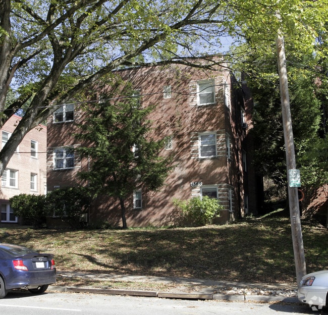
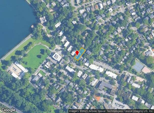
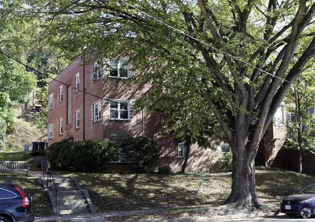
4569 Macarthur Blvd Nw, Washington, DC 20007
NEARBY LISTINGS FOR SALE OR LEASE
Property Detail
4569 Macarthur Blvd Nw
Washington-Arlington-Alexandria, DC-VA-MD-WV
Palisades
1367-0880
SQUARE 1367 LOT 0880 NBHD: PALISADES
Apartment
District of Columbia
X
District of Columbia
1100010012C
880
2025
0.19 AC
2025
Foxhall DC
000802
Washington, DC
6,918 SF
DEMOGRAPHICS near 4569 Macarthur Blvd Nw
1 Mile
3 Mile
5 Mile
2024 Total Population
14,920
250,897
705,223
2029 Population
13,815
236,203
669,431
Pop Growth 2024-2029
(7.41%)
(5.86%)
(5.08%)
Average Age
37
38
38
2024 Total Households
6,525
124,652
331,390
HH Growth 2024-2029
(7.65%)
(6.75%)
(5.71%)
Median Household Inc
$138,782
$129,474
$120,275
Avg Household Size
2.10
1.90
2.00
2024 Avg HH Vehicles
1.00
1.00
1.00
Median Home Value
$1,032,130
$913,367
$824,178
Median Year Built
1957
1963
1967
Nearby Places
Map Layers
Map Styles
 Street
 Aerial
- Restaurants
- Banks
- Shops
- Fitness
- Groceries
PUBLIC TRANSPORTATION
COMMUTER RAIL
L'Enfant (Fredericksburg Line - Virginia Railway Express, Manassas Line - Virginia Railway Express)
DRIVE
WALK
Distance
L'Enfant (Fredericksburg Line - Virginia Railway Express, Manassas Line - Virginia Railway Express)
9 min
4.7 mi
DRIVE
WALK
Distance
9 min
4.8 mi
AIRPORT
Ronald Reagan Washington Ntl
DRIVE
WALK
Distance
Ronald Reagan Washington Ntl
13 min
6.4 mi
Washington Dulles International
DRIVE
WALK
Distance
Washington Dulles International
41 min
22.6 mi
Baltimore/Washington International Thurgood Marshall
DRIVE
WALK
Distance
Baltimore/Washington International Thurgood Marshall
53 min
34.7 mi
Freight Ports
Port of Baltimore
DRIVE
WALK
Distance
Port of Baltimore
59 min
41.8 mi
Nearby Properties
Address
Land Use
TOTAL SIZE
Lot Size
Zoning
Address
Land Use
TOTAL SIZE
Lot Size
Zoning
533,778 SF
18.08 AC
UNZONED
Address
Land Use
TOTAL SIZE
Lot Size
Zoning
2,455,000 SF
11.08 AC
MU-2
Address
Land Use
TOTAL SIZE
Lot Size
Zoning
52.44 AC
UNZONED
Address
Land Use
TOTAL SIZE
Lot Size
Zoning
1,100,000 SF
2.13 AC
D-6
Address
Land Use
TOTAL SIZE
Lot Size
Zoning
1,310,661 SF
3.38 AC
D-6
Address
Land Use
TOTAL SIZE
Lot Size
Zoning
1.57 AC
D-5
Address
Land Use
TOTAL SIZE
Lot Size
Zoning
553,914 SF
55.91 AC
R-1B
Address
Land Use
TOTAL SIZE
Lot Size
Zoning
1,185,122 SF
2.43 AC
D-6
Address
Land Use
TOTAL SIZE
Lot Size
Zoning
1,214,044 SF
1.48 AC
D-6
Address
Land Use
TOTAL SIZE
Lot Size
Zoning
469,183 SF
1.20 AC
D-5
Address
Land Use
TOTAL SIZE
Lot Size
Zoning
900,000 SF
260 AC
S-3A
Address
Land Use
TOTAL SIZE
Lot Size
Zoning
900,000 SF
12.60 AC
RA-4
Address
Land Use
TOTAL SIZE
Lot Size
Zoning
5.26 AC
UNZONED
Address
Land Use
TOTAL SIZE
Lot Size
Zoning
77.26 AC
R-3/GT
Address
Land Use
TOTAL SIZE
Lot Size
Zoning
636,768 SF
1.91 AC
C-O-ROSSLY
Address
Land Use
TOTAL SIZE
Lot Size
Zoning
247,900 SF
170.58 AC
RA-2;UNZON
Address
Land Use
TOTAL SIZE
Lot Size
Zoning
1,018,056 SF
1.14 AC
D-6
Address
Land Use
TOTAL SIZE
Lot Size
Zoning
776,520 SF
1.49 AC
MU-9B
Address
Land Use
TOTAL SIZE
Lot Size
Zoning
1,365,427 SF
2.62 AC
MU-9B;RA-4
Address
Land Use
TOTAL SIZE
Lot Size
Zoning
499,000 SF
1.49 AC
RA-4
Address
Land Use
TOTAL SIZE
Lot Size
Zoning
400,000 SF
1.30 AC
RA-4
Address
Land Use
TOTAL SIZE
Lot Size
Zoning
20.19 AC
S-3A/S-D
Address
Land Use
TOTAL SIZE
Lot Size
Zoning
431,570 SF
0.78 AC
D-6
Address
Land Use
TOTAL SIZE
Lot Size
Zoning
430,428 SF
0.76 AC
D-6
Address
Land Use
TOTAL SIZE
Lot Size
Zoning
550,211 SF
1.42 AC
D-6
Address
Land Use
TOTAL SIZE
Lot Size
Zoning
482,000 SF
1.17 AC
MU-9B;RA-4
Address
Land Use
TOTAL SIZE
Lot Size
Zoning
502,963 SF
0.84 AC
D-6
Address
Land Use
TOTAL SIZE
Lot Size
Zoning
Address
Land Use
TOTAL SIZE
Lot Size
Zoning
45,523 SF
0.24 AC
C-O-ROSSLY
The World's #1 Commercial Real Estate Marketplace
Connect with us
© 2025 CoStar Group
The information above has been obtained from sources believed reliable. While we do not doubt its accuracy we have not verified it and make no guarantee, warranty or representation about it. It is your responsibility to independently confirm its accuracy and completeness. Any projections, opinions, assumptions, or estimates used are for example only and do not represent the current or future performance of the property. The value of this transaction to you depends on tax and other factors which should be evaluated by your tax, financial, and legal advisors. You and your advisors should conduct a careful, independent investigation of the property to determine to your satisfaction the suitability of the property for your needs.