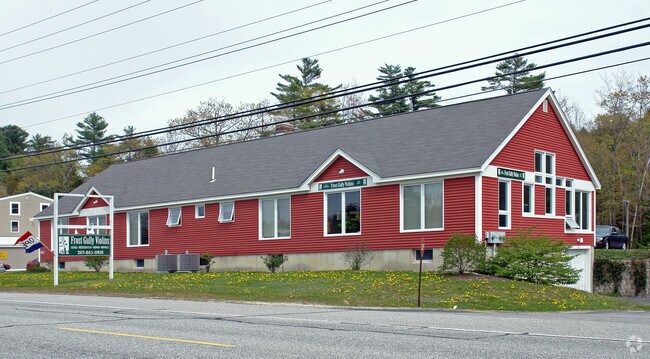
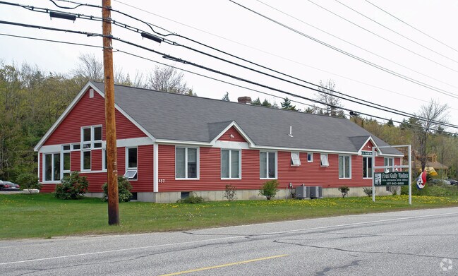
Property Record
457 Us Route 1, Freeport, ME 04032

Save to a Folder
{{folder.Name}}
{{folder.ListingIds.length}} Properties
{{folder.ListingIds.length}} Property
Create a New Folder
Property Detail
457 Us Route 1
Departmentstore
CUMBERLAND
CM03
Maine
B and X Area of moderate flood hazard, usually the area between the limits of the 100-year and 500-year floods.
1.70 AC
2025
NE Cumberland County
2025
Portland/South Portland
004502
Portland-South Portland, ME
3,236 SF
FPRT-000023-000062
NEARBY LISTINGS FOR SALE OR LEASE
DEMOGRAPHICS near 457 Us Route 1
1 mile
3 mile
5 mile
2025 Total Population
905
6,731
18,401
2030 Population
924
6,875
18,711
Pop Growth 2025-2030
+ 2.10%
+ 2.14%
+ 1.68%
Average Age
46
45
44
2025 Total Households
364
2,736
7,263
HH Growth 2025-2030
+ 1.92%
+ 2.19%
+ 1.80%
Median Household Inc
$110,887
$105,288
$115,662
Avg Household Size
2.30
2.30
2.40
2025 Avg HH Vehicles
2.00
2.00
2.00
Median Home Value
$623,786
$604,056
$636,660
Median Year Built
1976
1977
1976
Nearby Places
Map Layers
Map Styles
 Street
 Aerial
Layers
 Traffic
 Biking
Places
Listings with unknown addresses are not visible on the map
- Restaurants
- Banks
- Shops
- Fitness
- Groceries
PUBLIC TRANSPORTATION
COMMUTER RAIL
Drive
Walk
Distance
4 min
1.9 mi
AIRPORT
Portland International Jetport
Drive
Walk
Distance
Portland International Jetport
27 min
18.3 mi
Freight Ports
Portland, ME
Drive
Walk
Distance
Portland, ME
21 min
15.3 mi
SALE & LEASE HISTORY
LISTING DATE
SALE/LEASE

Dec 03, 2025
For Lease
Nearby Properties
Address
Land Use
TOTAL SIZE
Lot Size
Zoning
Address
Land Use
TOTAL SIZE
Lot Size
Zoning
90 AC
CM03
Address
Land Use
TOTAL SIZE
Lot Size
Zoning
3.63 AC
CM01
Address
Land Use
TOTAL SIZE
Lot Size
Zoning
24 AC
CM02
Address
Land Use
TOTAL SIZE
Lot Size
Zoning
38.65 AC
CM03
Address
Land Use
TOTAL SIZE
Lot Size
Zoning
7.53 AC
CM01
Address
Land Use
TOTAL SIZE
Lot Size
Zoning
350,171 SF
78.45 AC
CM03
Address
Land Use
TOTAL SIZE
Lot Size
Zoning
432,630 SF
CM03
Address
Land Use
TOTAL SIZE
Lot Size
Zoning
9.69 AC
CD4-C1
Address
Land Use
TOTAL SIZE
Lot Size
Zoning
20 AC
CM03
Address
Land Use
TOTAL SIZE
Lot Size
Zoning
93,752 SF
10.86 AC
21
Address
Land Use
TOTAL SIZE
Lot Size
Zoning
2,469 SF
3.84 AC
CM03
Address
Land Use
TOTAL SIZE
Lot Size
Zoning
5.15 AC
CM03
Address
Land Use
TOTAL SIZE
Lot Size
Zoning
1.46 AC
CM03
Address
Land Use
TOTAL SIZE
Lot Size
Zoning
45,829 SF
0.94 AC
CM01
Address
Land Use
TOTAL SIZE
Lot Size
Zoning
58,718 SF
13 AC
CM03
Address
Land Use
TOTAL SIZE
Lot Size
Zoning
59,699 SF
6.60 AC
CM02
Address
Land Use
TOTAL SIZE
Lot Size
Zoning
22.47 AC
1150
Address
Land Use
TOTAL SIZE
Lot Size
Zoning
2.10 AC
21
Address
Land Use
TOTAL SIZE
Lot Size
Zoning
60,270 SF
21.80 AC
CM03
Address
Land Use
TOTAL SIZE
Lot Size
Zoning
Address
Land Use
TOTAL SIZE
Lot Size
Zoning
84.10 AC
1100
Address
Land Use
TOTAL SIZE
Lot Size
Zoning
29,680 SF
0.79 AC
CM01
Address
Land Use
TOTAL SIZE
Lot Size
Zoning
39,225 SF
21.43 AC
CM03
Address
Land Use
TOTAL SIZE
Lot Size
Zoning
45,879 SF
6.62 AC
CM04
Address
Land Use
TOTAL SIZE
Lot Size
Zoning
1.01 AC
CM02
Address
Land Use
TOTAL SIZE
Lot Size
Zoning
41,451 SF
2.90 AC
CM03
Address
Land Use
TOTAL SIZE
Lot Size
Zoning
38,209 SF
2.26 AC
CM02
Address
Land Use
TOTAL SIZE
Lot Size
Zoning
62,857 SF
23.10 AC
CM04
Address
Land Use
TOTAL SIZE
Lot Size
Zoning
38,323 SF
2.14 AC
CM03
Address
Land Use
TOTAL SIZE
Lot Size
Zoning
5.11 AC
CM02
The World's #1 Commercial Real Estate Marketplace
Connect with us
© 2026 CoStar Group
The information above has been obtained from sources believed reliable. While we do not doubt its accuracy we have not verified it and make no guarantee, warranty or representation about it. It is your responsibility to independently confirm its accuracy and completeness. Any projections, opinions, assumptions, or estimates used are for example only and do not represent the current or future performance of the property. The value of this transaction to you depends on tax and other factors which should be evaluated by your tax, financial, and legal advisors. You and your advisors should conduct a careful, independent investigation of the property to determine to your satisfaction the suitability of the property for your needs.