Property Record
460 N Catawba Way, Aurora, CO 80018


NEARBY LISTINGS FOR SALE OR LEASE
Property Detail
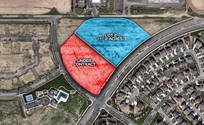
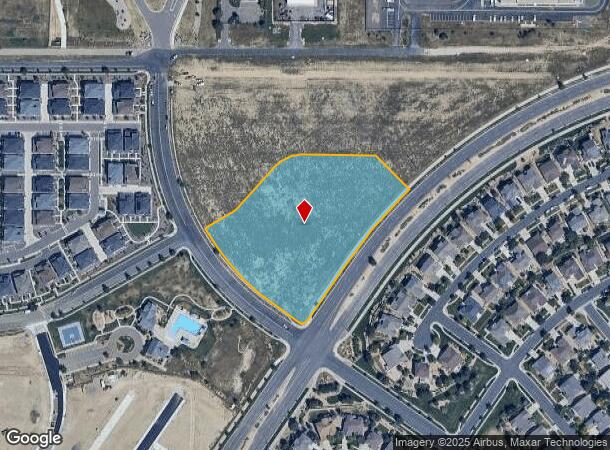
460 N Catawba Way
Denver-Aurora-Lakewood, CO
Cross Creek Sub 2Nd Flg
1977-07-2-13-004
SUBDIVISIONCD 018131 SUBDIVISIONNAME CROSS CREEK SUB 2ND FLG BLOCK 000 LOT 00A THAT PART OF TRACT A CROSS CREEK SUB 2ND FLG DESC AS BEG AT THE MOST ELY COR OF SD TRACT A TH ALG CURVE TO LEFT 299.08 FT TH SW 204.7 FT TH ALG CURVE RT 23.56 FT TH NW 78.
Commercialacreage
Arapahoe
X
Colorado
08001C0930J
00a
2023
4.12 AC
2024
Outlying Arapahoe County
007108
Denver
DEMOGRAPHICS near 460 N Catawba Way
1 Mile
3 Mile
5 Mile
2024 Total Population
3,121
17,564
85,700
2029 Population
3,193
18,241
86,463
Pop Growth 2024-2029
+ 2.31%
+ 3.85%
+ 0.89%
Average Age
37
35
36
2024 Total Households
1,009
5,441
27,972
HH Growth 2024-2029
+ 2.18%
+ 3.68%
+ 0.75%
Median Household Inc
$133,077
$107,883
$85,332
Avg Household Size
3.00
3.10
2.90
2024 Avg HH Vehicles
2.00
2.00
2.00
Median Home Value
$480,239
$473,679
$397,093
Median Year Built
2009
2010
1996
Nearby Places
Map Layers
Map Styles
 Street
 Aerial
- Restaurants
- Banks
- Shops
- Fitness
- Groceries
PUBLIC TRANSPORTATION
COMMUTER RAIL
40Th Ave & Airport Blvd - Gateway Park Station Track 2 (Union Station to Denver Airport Station - Regional Transportation District)
DRIVE
WALK
Distance
40Th Ave & Airport Blvd - Gateway Park Station Track 2 (Union Station to Denver Airport Station - Regional Transportation District)
12 min
6.9 mi
61St & Pena Station Track 2 (Union Station to Denver Airport Station - Regional Transportation District)
DRIVE
WALK
Distance
61St & Pena Station Track 2 (Union Station to Denver Airport Station - Regional Transportation District)
15 min
9.4 mi
AIRPORT
Denver International
DRIVE
WALK
Distance
Denver International
17 min
14.7 mi
Freight Ports
Tulsa Port Of Catoosa
DRIVE
WALK
Distance
Tulsa Port Of Catoosa
710 min
694.6 mi
SALE & LEASE HISTORY
LISTING DATE
SALE/LEASE

Sep 24, 2016
For Sale
Nearby Properties
Address
Land Use
TOTAL SIZE
Lot Size
Zoning
Address
Land Use
TOTAL SIZE
Lot Size
Zoning
1,078,683 SF
68.01 AC
Address
Land Use
TOTAL SIZE
Lot Size
Zoning
1,016,116 SF
69.40 AC
Address
Land Use
TOTAL SIZE
Lot Size
Zoning
632,815 SF
34.66 AC
A3
Address
Land Use
TOTAL SIZE
Lot Size
Zoning
582,400 SF
43.29 AC
Address
Land Use
TOTAL SIZE
Lot Size
Zoning
555,867 SF
33.81 AC
Address
Land Use
TOTAL SIZE
Lot Size
Zoning
517,368 SF
29.74 AC
Address
Land Use
TOTAL SIZE
Lot Size
Zoning
455,520 SF
53.29 AC
Address
Land Use
TOTAL SIZE
Lot Size
Zoning
433,280 SF
23.46 AC
Address
Land Use
TOTAL SIZE
Lot Size
Zoning
593,928 SF
32.25 AC
Address
Land Use
TOTAL SIZE
Lot Size
Zoning
432,600 SF
30.98 AC
Address
Land Use
TOTAL SIZE
Lot Size
Zoning
409,124 SF
22.18 AC
Address
Land Use
TOTAL SIZE
Lot Size
Zoning
404,800 SF
23.17 AC
Address
Land Use
TOTAL SIZE
Lot Size
Zoning
357,850 SF
19.15 AC
Address
Land Use
TOTAL SIZE
Lot Size
Zoning
334,601 SF
25.93 AC
Address
Land Use
TOTAL SIZE
Lot Size
Zoning
220,000 SF
17.22 AC
Address
Land Use
TOTAL SIZE
Lot Size
Zoning
348,536 SF
77.27 AC
Address
Land Use
TOTAL SIZE
Lot Size
Zoning
255,045 SF
16.59 AC
Address
Land Use
TOTAL SIZE
Lot Size
Zoning
284,568 SF
15.72 AC
Address
Land Use
TOTAL SIZE
Lot Size
Zoning
251,680 SF
19.21 AC
Address
Land Use
TOTAL SIZE
Lot Size
Zoning
250,536 SF
15.31 AC
Address
Land Use
TOTAL SIZE
Lot Size
Zoning
209,116 SF
18.22 AC
Address
Land Use
TOTAL SIZE
Lot Size
Zoning
163,386 SF
10.02 AC
Address
Land Use
TOTAL SIZE
Lot Size
Zoning
157,600 SF
9.14 AC
Address
Land Use
TOTAL SIZE
Lot Size
Zoning
219,814 SF
12.91 AC
Address
Land Use
TOTAL SIZE
Lot Size
Zoning
89,081 SF
59.34 AC
Address
Land Use
TOTAL SIZE
Lot Size
Zoning
4,080 SF
116.55 AC
Address
Land Use
TOTAL SIZE
Lot Size
Zoning
345,545 SF
8.03 AC
RE470
Address
Land Use
TOTAL SIZE
Lot Size
Zoning
109.99 AC
Address
Land Use
TOTAL SIZE
Lot Size
Zoning
76.22 AC
Address
Land Use
TOTAL SIZE
Lot Size
Zoning
112,638 SF
6.75 AC
M1
The World's #1 Commercial Real Estate Marketplace
Connect with us
© 2025 CoStar Group
The information above has been obtained from sources believed reliable. While we do not doubt its accuracy we have not verified it and make no guarantee, warranty or representation about it. It is your responsibility to independently confirm its accuracy and completeness. Any projections, opinions, assumptions, or estimates used are for example only and do not represent the current or future performance of the property. The value of this transaction to you depends on tax and other factors which should be evaluated by your tax, financial, and legal advisors. You and your advisors should conduct a careful, independent investigation of the property to determine to your satisfaction the suitability of the property for your needs.