Property Record
4600 53Rd St, Moline, IL 61265
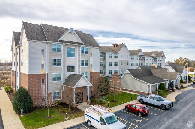

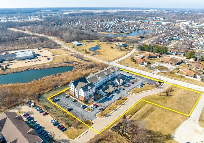
Property Detail
4600 53Rd St
17-14-115-001
LOT 1 HILAND 2ND ADD SHT 40 AND 41
Commercialnec
Rock Island
MOL
Illinois
AE The base floodplain where base flood elevations are provided. AE Zones are now used on new format FIRMs instead of A1-A30 Zones.
1
2025
3.14 AC
2025
Davenport/Moline
021100
Davenport/Moline/Rock Island
49,673 SF
Davenport-Moline-Rock Island, IA-IL
NEARBY LISTINGS FOR SALE OR LEASE
-
-
View all Moline listings for sale on LoopNet.com
DEMOGRAPHICS near 4600 53Rd St
1 mile
3 mile
5 mile
2025 Total Population
5,148
43,517
93,969
2030 Population
5,165
43,282
93,678
Pop Growth 2025-2030
+ 0.33%
(0.54%)
(0.31%)
Average Age
41
42
41
2025 Total Households
2,211
18,953
40,276
HH Growth 2025-2030
+ 0.27%
(0.51%)
(0.30%)
Median Household Inc
$74,148
$71,195
$65,339
Avg Household Size
2.20
2.20
2.30
2025 Avg HH Vehicles
2.00
2.00
2.00
Median Home Value
$226,885
$172,755
$159,425
Median Year Built
1974
1966
1960
Nearby Places
Map Layers
Map Styles
 Street
 Aerial
Layers
 Traffic
 Biking
Places
Listings with unknown addresses are not visible on the map
- Restaurants
- Banks
- Shops
- Fitness
- Groceries
PUBLIC TRANSPORTATION
AIRPORT
Quad Cities International
Drive
Walk
Distance
Quad Cities International
10 min
4.1 mi
Freight Ports
Port Milwaukee
Drive
Walk
Distance
Port Milwaukee
231 min
204.4 mi
SALE & LEASE HISTORY
LISTING DATE
SALE/LEASE

Sep 08, 2023
For Sale
Feb 21, 2023
For Sale
Dec 12, 2022
For Sale
Nearby Properties
Address
Land Use
TOTAL SIZE
Lot Size
Zoning
Address
Land Use
TOTAL SIZE
Lot Size
Zoning
333.38 AC
B3
Address
Land Use
TOTAL SIZE
Lot Size
Zoning
250,875 SF
11.92 AC
MOL
Address
Land Use
TOTAL SIZE
Lot Size
Zoning
333,348 SF
30.81 AC
EM
Address
Land Use
TOTAL SIZE
Lot Size
Zoning
166,102 SF
4.36 AC
SIL
Address
Land Use
TOTAL SIZE
Lot Size
Zoning
132,647 SF
13.76 AC
MOL
Address
Land Use
TOTAL SIZE
Lot Size
Zoning
19.69 AC
MOL
Address
Land Use
TOTAL SIZE
Lot Size
Zoning
194,267 SF
23.16 AC
MOL
Address
Land Use
TOTAL SIZE
Lot Size
Zoning
244,440 SF
13.25 AC
MOL
Address
Land Use
TOTAL SIZE
Lot Size
Zoning
46,917 SF
4.57 AC
SIL
Address
Land Use
TOTAL SIZE
Lot Size
Zoning
10.75 AC
MOL
Address
Land Use
TOTAL SIZE
Lot Size
Zoning
142,836 SF
14.60 AC
MOL
Address
Land Use
TOTAL SIZE
Lot Size
Zoning
66.76 AC
MOL
Address
Land Use
TOTAL SIZE
Lot Size
Zoning
73,065 SF
12.67 AC
I2
Address
Land Use
TOTAL SIZE
Lot Size
Zoning
47,578 SF
23.65 AC
MOL
Address
Land Use
TOTAL SIZE
Lot Size
Zoning
9.42 AC
I2
Address
Land Use
TOTAL SIZE
Lot Size
Zoning
203,904 SF
12.75 AC
MOL
Address
Land Use
TOTAL SIZE
Lot Size
Zoning
134,142 SF
13.31 AC
EM
Address
Land Use
TOTAL SIZE
Lot Size
Zoning
3.12 AC
SIL
Address
Land Use
TOTAL SIZE
Lot Size
Zoning
53,897 SF
3.13 AC
MOL
Address
Land Use
TOTAL SIZE
Lot Size
Zoning
144,306 SF
16.90 AC
EM
Address
Land Use
TOTAL SIZE
Lot Size
Zoning
9.18 AC
MOL
Address
Land Use
TOTAL SIZE
Lot Size
Zoning
162,924 SF
17.18 AC
MOL
Address
Land Use
TOTAL SIZE
Lot Size
Zoning
55.60 AC
CV
Address
Land Use
TOTAL SIZE
Lot Size
Zoning
30,836 SF
4.91 AC
MOL
Address
Land Use
TOTAL SIZE
Lot Size
Zoning
46.02 AC
MOL
Address
Land Use
TOTAL SIZE
Lot Size
Zoning
10.76 AC
MOL
Address
Land Use
TOTAL SIZE
Lot Size
Zoning
107,880 SF
1.79 AC
EM
Address
Land Use
TOTAL SIZE
Lot Size
Zoning
81,027 SF
6.57 AC
SIL
Address
Land Use
TOTAL SIZE
Lot Size
Zoning
63,972 SF
2.66 AC
MOL
Address
Land Use
TOTAL SIZE
Lot Size
Zoning
130,200 SF
3 AC
EM
The World's #1 Commercial Real Estate Marketplace
Connect with us
© 2026 CoStar Group
The information above has been obtained from sources believed reliable. While we do not doubt its accuracy we have not verified it and make no guarantee, warranty or representation about it. It is your responsibility to independently confirm its accuracy and completeness. Any projections, opinions, assumptions, or estimates used are for example only and do not represent the current or future performance of the property. The value of this transaction to you depends on tax and other factors which should be evaluated by your tax, financial, and legal advisors. You and your advisors should conduct a careful, independent investigation of the property to determine to your satisfaction the suitability of the property for your needs.