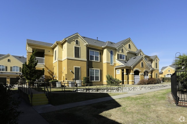
Property Record
4600 Nuckols Crossing Rd, Austin, TX 78744


Save to a Folder
{{folder.Name}}
{{folder.ListingIds.length}} Properties
{{folder.ListingIds.length}} Property
Create a New Folder
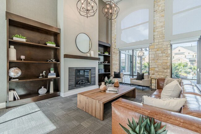
Property Detail
4600 Nuckols Crossing Rd
Austin-Round Rock-San Marcos, TX
ABS 24 DELVALLE S ACR 12.1882
293211
TRAVIS
Multifamilydwelling
Texas
B and X Area of moderate flood hazard, usually the area between the limits of the 100-year and 500-year floods.
1
0
12.19 AC
2025
Franklin Park
002413
Austin
206,299 SF
NEARBY LISTINGS FOR SALE OR LEASE
DEMOGRAPHICS near 4600 Nuckols Crossing Rd
1 mile
3 mile
5 mile
2025 Total Population
11,622
126,019
290,626
2030 Population
12,162
132,582
306,806
Pop Growth 2025-2030
+ 4.65%
+ 5.21%
+ 5.57%
Average Age
35
35
37
2025 Total Households
3,362
52,508
130,726
HH Growth 2025-2030
+ 5.32%
+ 5.92%
+ 6.27%
Median Household Inc
$73,025
$72,663
$89,330
Avg Household Size
3.30
2.30
2.10
2025 Avg HH Vehicles
2.00
2.00
2.00
Median Home Value
$367,588
$430,266
$547,336
Median Year Built
1996
1996
2002
Nearby Places
Map Layers
Map Styles
 Street
 Aerial
Layers
 Traffic
 Biking
Places
Listings with unknown addresses are not visible on the map
- Restaurants
- Banks
- Shops
- Fitness
- Groceries
PUBLIC TRANSPORTATION
COMMUTER RAIL
Austin (Texas Eagle - Amtrak)
Drive
Walk
Distance
Austin (Texas Eagle - Amtrak)
14 min
7.3 mi
AIRPORT
Austin-Bergstrom International
Drive
Walk
Distance
Austin-Bergstrom International
18 min
7.8 mi
Freight Ports
Calhoun Port
Drive
Walk
Distance
Calhoun Port
184 min
151.3 mi
Nearby Properties
Address
Land Use
TOTAL SIZE
Lot Size
Zoning
Address
Land Use
TOTAL SIZE
Lot Size
Zoning
8,213 SF
36.95 AC
Address
Land Use
TOTAL SIZE
Lot Size
Zoning
368,349 SF
17.13 AC
Address
Land Use
TOTAL SIZE
Lot Size
Zoning
456,650 SF
15 AC
Address
Land Use
TOTAL SIZE
Lot Size
Zoning
307,610 SF
8.95 AC
Address
Land Use
TOTAL SIZE
Lot Size
Zoning
454,740 SF
27.77 AC
Address
Land Use
TOTAL SIZE
Lot Size
Zoning
290,643 SF
13.59 AC
Address
Land Use
TOTAL SIZE
Lot Size
Zoning
539,533 SF
26.50 AC
Address
Land Use
TOTAL SIZE
Lot Size
Zoning
386,952 SF
6.77 AC
Address
Land Use
TOTAL SIZE
Lot Size
Zoning
255,483 SF
35 AC
Address
Land Use
TOTAL SIZE
Lot Size
Zoning
335,913 SF
13.83 AC
Address
Land Use
TOTAL SIZE
Lot Size
Zoning
390,384 SF
34.08 AC
Address
Land Use
TOTAL SIZE
Lot Size
Zoning
272,084 SF
3.87 AC
Address
Land Use
TOTAL SIZE
Lot Size
Zoning
256,182 SF
3.63 AC
Address
Land Use
TOTAL SIZE
Lot Size
Zoning
281,588 SF
6.29 AC
Address
Land Use
TOTAL SIZE
Lot Size
Zoning
266,871 SF
9.13 AC
Address
Land Use
TOTAL SIZE
Lot Size
Zoning
287,925 SF
9.92 AC
Address
Land Use
TOTAL SIZE
Lot Size
Zoning
372,125 SF
26.22 AC
Address
Land Use
TOTAL SIZE
Lot Size
Zoning
314,325 SF
29.53 AC
Address
Land Use
TOTAL SIZE
Lot Size
Zoning
264,897 SF
2.54 AC
Address
Land Use
TOTAL SIZE
Lot Size
Zoning
297,552 SF
15.93 AC
Address
Land Use
TOTAL SIZE
Lot Size
Zoning
193,788 SF
107.16 AC
Address
Land Use
TOTAL SIZE
Lot Size
Zoning
359,144 SF
Address
Land Use
TOTAL SIZE
Lot Size
Zoning
210,375 SF
3.36 AC
Address
Land Use
TOTAL SIZE
Lot Size
Zoning
288,174 SF
18.91 AC
Address
Land Use
TOTAL SIZE
Lot Size
Zoning
402,658 SF
20.26 AC
Address
Land Use
TOTAL SIZE
Lot Size
Zoning
262,576 SF
15.68 AC
Address
Land Use
TOTAL SIZE
Lot Size
Zoning
231,634 SF
2.78 AC
Address
Land Use
TOTAL SIZE
Lot Size
Zoning
315,198 SF
8.88 AC
Address
Land Use
TOTAL SIZE
Lot Size
Zoning
226,050 SF
2.28 AC
Address
Land Use
TOTAL SIZE
Lot Size
Zoning
1 SF
25.43 AC
The World's #1 Commercial Real Estate Marketplace
Connect with us
© 2026 CoStar Group
The information above has been obtained from sources believed reliable. While we do not doubt its accuracy we have not verified it and make no guarantee, warranty or representation about it. It is your responsibility to independently confirm its accuracy and completeness. Any projections, opinions, assumptions, or estimates used are for example only and do not represent the current or future performance of the property. The value of this transaction to you depends on tax and other factors which should be evaluated by your tax, financial, and legal advisors. You and your advisors should conduct a careful, independent investigation of the property to determine to your satisfaction the suitability of the property for your needs.