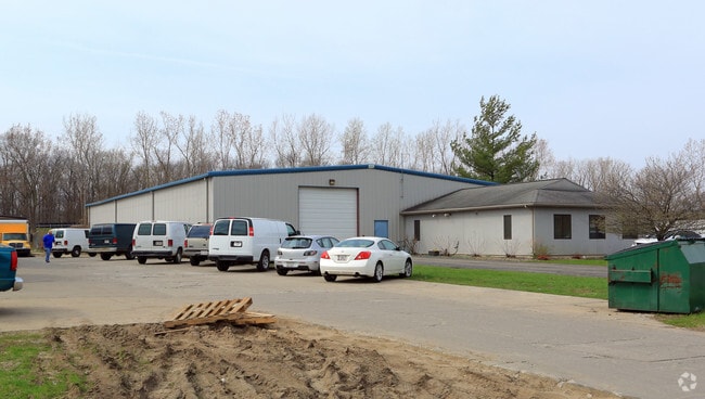
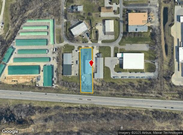
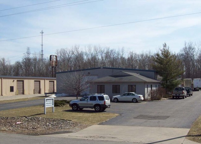
Property Record
4616 S Burnett Dr, South Bend, IN 46614
NEARBY LISTINGS FOR SALE OR LEASE
Property Detail
4616 S Burnett Dr
South Bend-Mishawaka, IN-MI
Burnett Industrial Park Minor Sub
71-08-26-403-006.000-002
LOT 6AA BURNETT INDUSTRIAL PARK MINOR SUB
Warehouse
St Joseph
A
Indiana
18141C0194D
6
2023
1.14 AC
2024
Greater South Bend
003400
South Bend/Mishawaka
9,950 SF
DEMOGRAPHICS near 4616 S Burnett Dr
1 Mile
3 Mile
5 Mile
2024 Total Population
1,612
40,205
121,173
2029 Population
1,588
40,085
121,698
Pop Growth 2024-2029
(1.49%)
(0.30%)
+ 0.43%
Average Age
44
39
37
2024 Total Households
668
15,754
47,243
HH Growth 2024-2029
(1.65%)
(0.46%)
+ 0.39%
Median Household Inc
$79,412
$55,791
$49,615
Avg Household Size
2.40
2.40
2.40
2024 Avg HH Vehicles
2.00
2.00
2.00
Median Home Value
$193,170
$141,466
$123,398
Median Year Built
1977
1961
1956
Nearby Places
Map Layers
Map Styles
 Street
 Aerial
- Restaurants
- Banks
- Shops
- Fitness
- Groceries
PUBLIC TRANSPORTATION
COMMUTER RAIL
South Bend Amtrak Station (Capitol Limited - Amtrak, Lake Shore Limited - Amtrak)
DRIVE
WALK
Distance
South Bend Amtrak Station (Capitol Limited - Amtrak, Lake Shore Limited - Amtrak)
13 min
5.1 mi
South Bend Airport Station (South Shore Line - Northern Indiana Commuter Transportation District (South Shore Line))
DRIVE
WALK
Distance
South Bend Airport Station (South Shore Line - Northern Indiana Commuter Transportation District (South Shore Line))
16 min
9.2 mi
AIRPORT
South Bend International
DRIVE
WALK
Distance
South Bend International
23 min
10.0 mi
Freight Ports
Port Milwaukee
DRIVE
WALK
Distance
Port Milwaukee
222 min
184.2 mi
Nearby Properties
Address
Land Use
TOTAL SIZE
Lot Size
Zoning
Address
Land Use
TOTAL SIZE
Lot Size
Zoning
270,484 SF
131 SF
Address
Land Use
TOTAL SIZE
Lot Size
Zoning
338,816 SF
33.65 AC
Address
Land Use
TOTAL SIZE
Lot Size
Zoning
283,481 SF
51.29 AC
Address
Land Use
TOTAL SIZE
Lot Size
Zoning
231,450 SF
87 SF
Address
Land Use
TOTAL SIZE
Lot Size
Zoning
194,931 SF
44 SF
Address
Land Use
TOTAL SIZE
Lot Size
Zoning
25,228 SF
68.61 AC
Address
Land Use
TOTAL SIZE
Lot Size
Zoning
544,872 SF
70.95 AC
Address
Land Use
TOTAL SIZE
Lot Size
Zoning
221,887 SF
87 SF
Address
Land Use
TOTAL SIZE
Lot Size
Zoning
174,526 SF
24.37 AC
Address
Land Use
TOTAL SIZE
Lot Size
Zoning
633,136 SF
2.59 AC
Address
Land Use
TOTAL SIZE
Lot Size
Zoning
74,976 SF
44 SF
Address
Land Use
TOTAL SIZE
Lot Size
Zoning
91,091 SF
131 SF
Address
Land Use
TOTAL SIZE
Lot Size
Zoning
136,568 SF
44 SF
Address
Land Use
TOTAL SIZE
Lot Size
Zoning
79,760 SF
13.17 AC
Address
Land Use
TOTAL SIZE
Lot Size
Zoning
79,911 SF
18.98 AC
Address
Land Use
TOTAL SIZE
Lot Size
Zoning
123,359 SF
44 SF
Address
Land Use
TOTAL SIZE
Lot Size
Zoning
87,310 SF
44 SF
Address
Land Use
TOTAL SIZE
Lot Size
Zoning
93,530 SF
8.08 AC
Address
Land Use
TOTAL SIZE
Lot Size
Zoning
58,135 SF
174 SF
Address
Land Use
TOTAL SIZE
Lot Size
Zoning
15,436 SF
174 SF
Address
Land Use
TOTAL SIZE
Lot Size
Zoning
62,834 SF
87 SF
Address
Land Use
TOTAL SIZE
Lot Size
Zoning
164,508 SF
61.83 AC
Address
Land Use
TOTAL SIZE
Lot Size
Zoning
158,495 SF
12.23 AC
Address
Land Use
TOTAL SIZE
Lot Size
Zoning
4,464 SF
131 SF
Address
Land Use
TOTAL SIZE
Lot Size
Zoning
52,648 SF
2.80 AC
Address
Land Use
TOTAL SIZE
Lot Size
Zoning
93,376 SF
23.93 AC
Address
Land Use
TOTAL SIZE
Lot Size
Zoning
46,060 SF
3.89 AC
Address
Land Use
TOTAL SIZE
Lot Size
Zoning
48,204 SF
44 SF
Address
Land Use
TOTAL SIZE
Lot Size
Zoning
52,500 SF
32.50 AC
Address
Land Use
TOTAL SIZE
Lot Size
Zoning
1,418,289 SF
74.42 AC
The World's #1 Commercial Real Estate Marketplace
Connect with us
© 2025 CoStar Group
The information above has been obtained from sources believed reliable. While we do not doubt its accuracy we have not verified it and make no guarantee, warranty or representation about it. It is your responsibility to independently confirm its accuracy and completeness. Any projections, opinions, assumptions, or estimates used are for example only and do not represent the current or future performance of the property. The value of this transaction to you depends on tax and other factors which should be evaluated by your tax, financial, and legal advisors. You and your advisors should conduct a careful, independent investigation of the property to determine to your satisfaction the suitability of the property for your needs.