Property Record
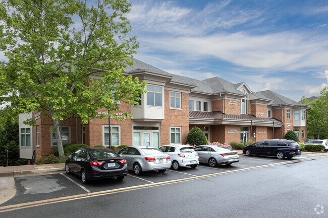
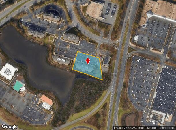
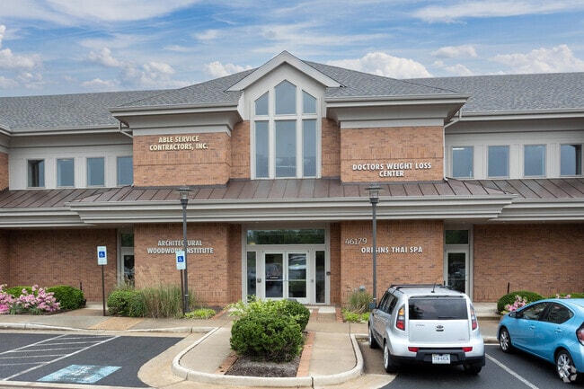
46179 Westlake Dr, Sterling, VA 20165
Current Lease Availabilities
NEARBY LISTINGS FOR SALE OR LEASE
Property Detail
46179 Westlake Dr
019-26-7880-001
Potomac Falls Professional Center Condo
Commercialcondominium
POTOMAC FALLS PROFESSIONAL CENTER CONDO PH.5 UNIT 100 200410200112865 (3) 200409280104915P
X
Loudoun
51107C0267E
Virginia
2025
Route 28 Corridor North
2025
Washington, DC
611207
Washington-Arlington-Alexandria, DC-VA-MD-WV
3,282 SF
DEMOGRAPHICS near 46179 Westlake Dr
1 Mile
3 Mile
5 Mile
2024 Total Population
15,454
92,077
182,307
2029 Population
16,576
98,433
191,830
Pop Growth 2024-2029
+ 7.26%
+ 6.90%
+ 5.22%
Average Age
37
39
39
2024 Total Households
5,360
31,299
63,040
HH Growth 2024-2029
+ 7.41%
+ 7.22%
+ 5.49%
Median Household Inc
$120,472
$128,809
$137,914
Avg Household Size
2.80
2.80
2.80
2024 Avg HH Vehicles
2.00
2.00
2.00
Median Home Value
$609,126
$556,333
$628,578
Median Year Built
1993
1990
1991
Nearby Places
- Restaurants
- Banks
- Shops
- Fitness
- Groceries
PUBLIC TRANSPORTATION
AIRPORT
Washington Dulles International
DRIVE
WALK
Distance
Washington Dulles International
19 min
8.7 mi
Ronald Reagan Washington Ntl
DRIVE
WALK
Distance
Ronald Reagan Washington Ntl
45 min
28.5 mi
Freight Ports
Port of Baltimore
DRIVE
WALK
Distance
Port of Baltimore
85 min
60.5 mi
Nearby Properties
Address
Land Use
TOTAL SIZE
Lot Size
Zoning
Address
Land Use
TOTAL SIZE
Lot Size
Zoning
650,346 SF
PDMUB
Address
Land Use
TOTAL SIZE
Lot Size
Zoning
672,272 SF
44.53 AC
PDIP
Address
Land Use
TOTAL SIZE
Lot Size
Zoning
2,735,138 SF
123.03 AC
PDAAAR
Address
Land Use
TOTAL SIZE
Lot Size
Zoning
364,600 SF
PDOP
Address
Land Use
TOTAL SIZE
Lot Size
Zoning
565,680 SF
18.44 AC
PDIP
Address
Land Use
TOTAL SIZE
Lot Size
Zoning
228,606 SF
PDOP
Address
Land Use
TOTAL SIZE
Lot Size
Zoning
154,125 SF
9.68 AC
PDIP
Address
Land Use
TOTAL SIZE
Lot Size
Zoning
364,650 SF
PDOP
Address
Land Use
TOTAL SIZE
Lot Size
Zoning
169,092 SF
PDMUB
Address
Land Use
TOTAL SIZE
Lot Size
Zoning
109,320 SF
7.20 AC
PDIP
Address
Land Use
TOTAL SIZE
Lot Size
Zoning
253,352 SF
PDOP
Address
Land Use
TOTAL SIZE
Lot Size
Zoning
685,682 SF
53.96 AC
PDIP
Address
Land Use
TOTAL SIZE
Lot Size
Zoning
481,791 SF
41.28 AC
PDIP
Address
Land Use
TOTAL SIZE
Lot Size
Zoning
180,039 SF
15.98 AC
PDOP
Address
Land Use
TOTAL SIZE
Lot Size
Zoning
259,194 SF
10.18 AC
PDIP
Address
Land Use
TOTAL SIZE
Lot Size
Zoning
219,514 SF
14.34 AC
PDIP
Address
Land Use
TOTAL SIZE
Lot Size
Zoning
446,732 SF
37.94 AC
PDIP
Address
Land Use
TOTAL SIZE
Lot Size
Zoning
119,087 SF
339.95 AC
PDIP
Address
Land Use
TOTAL SIZE
Lot Size
Zoning
429,711 SF
34.74 AC
PDH4
Address
Land Use
TOTAL SIZE
Lot Size
Zoning
426,710 SF
19.50 AC
PDIP
Address
Land Use
TOTAL SIZE
Lot Size
Zoning
430,507 SF
25.60 AC
R16
Address
Land Use
TOTAL SIZE
Lot Size
Zoning
396,198 SF
5.84 AC
PDMUB
Address
Land Use
TOTAL SIZE
Lot Size
Zoning
383,257 SF
33.05 AC
PDH4
Address
Land Use
TOTAL SIZE
Lot Size
Zoning
364,146 SF
38.05 AC
CCSC
Address
Land Use
TOTAL SIZE
Lot Size
Zoning
498,598 SF
21.89 AC
R16
Address
Land Use
TOTAL SIZE
Lot Size
Zoning
316,325 SF
18.08 AC
R16
Address
Land Use
TOTAL SIZE
Lot Size
Zoning
296,380 SF
24.36 AC
PDIP
Address
Land Use
TOTAL SIZE
Lot Size
Zoning
404,709 SF
18.57 AC
R24
Address
Land Use
TOTAL SIZE
Lot Size
Zoning
408,760 SF
87.24 AC
R1
The World's #1 Commercial Real Estate Marketplace
Connect with us
© 2025 CoStar Group
The information above has been obtained from sources believed reliable. While we do not doubt its accuracy we have not verified it and make no guarantee, warranty or representation about it. It is your responsibility to independently confirm its accuracy and completeness. Any projections, opinions, assumptions, or estimates used are for example only and do not represent the current or future performance of the property. The value of this transaction to you depends on tax and other factors which should be evaluated by your tax, financial, and legal advisors. You and your advisors should conduct a careful, independent investigation of the property to determine to your satisfaction the suitability of the property for your needs.