Property Record
4640 Cal Sag Rd, Crestwood, IL 60418
NEARBY LISTINGS FOR SALE OR LEASE
Property Detail
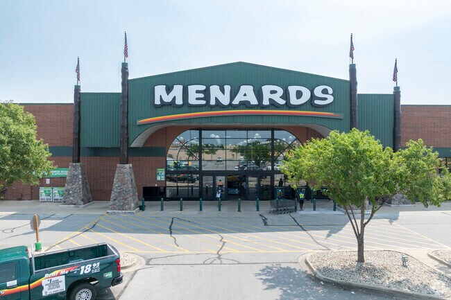
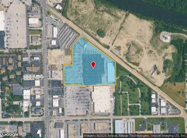
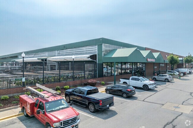
4640 Cal Sag Rd
24-34-302-045-0000
Crestwood Town Center
Commercialbuilding
Cook
X
Illinois
17031C0638J
1
2023
15.30 AC
2025
Near South Cook
823603
Chicago
185,748 SF
Chicago-Naperville-Elgin, IL-IN-WI
DEMOGRAPHICS near 4640 Cal Sag Rd
1 Mile
3 Mile
5 Mile
2024 Total Population
8,703
92,809
295,483
2029 Population
8,722
91,302
288,934
Pop Growth 2024-2029
+ 0.22%
(1.62%)
(2.22%)
Average Age
45
41
41
2024 Total Households
3,711
35,882
112,658
HH Growth 2024-2029
(0.27%)
(1.81%)
(2.50%)
Median Household Inc
$62,494
$65,420
$68,366
Avg Household Size
2.20
2.50
2.50
2024 Avg HH Vehicles
2.00
2.00
2.00
Median Home Value
$187,243
$199,961
$223,197
Median Year Built
1979
1971
1967
Nearby Places
Map Layers
Map Styles
 Street
 Aerial
- Restaurants
- Banks
- Shops
- Fitness
- Groceries
PUBLIC TRANSPORTATION
COMMUTER RAIL
Robbins Station (Rock Island District Line - Northeast Illinois Regional Commuter Railroad (Metra))
DRIVE
WALK
Distance
Robbins Station (Rock Island District Line - Northeast Illinois Regional Commuter Railroad (Metra))
7 min
2.7 mi
Midlothian Station (Rock Island District Line - Northeast Illinois Regional Commuter Railroad (Metra))
DRIVE
WALK
Distance
Midlothian Station (Rock Island District Line - Northeast Illinois Regional Commuter Railroad (Metra))
9 min
2.8 mi
AIRPORT
Chicago Midway International
DRIVE
WALK
Distance
Chicago Midway International
27 min
10.6 mi
Chicago O'Hare International
DRIVE
WALK
Distance
Chicago O'Hare International
42 min
32.7 mi
Nearby Properties
Address
Land Use
TOTAL SIZE
Lot Size
Zoning
Address
Land Use
TOTAL SIZE
Lot Size
Zoning
48,792 SF
8.71 AC
RT-4
Address
Land Use
TOTAL SIZE
Lot Size
Zoning
495,815 SF
20.78 AC
Address
Land Use
TOTAL SIZE
Lot Size
Zoning
101,169 SF
13.07 AC
Address
Land Use
TOTAL SIZE
Lot Size
Zoning
Address
Land Use
TOTAL SIZE
Lot Size
Zoning
401,021 SF
27.42 AC
Address
Land Use
TOTAL SIZE
Lot Size
Zoning
380,924 SF
19.13 AC
Address
Land Use
TOTAL SIZE
Lot Size
Zoning
421,052 SF
26.15 AC
Address
Land Use
TOTAL SIZE
Lot Size
Zoning
510,332 SF
23.97 AC
Address
Land Use
TOTAL SIZE
Lot Size
Zoning
34,970 SF
3.87 AC
Address
Land Use
TOTAL SIZE
Lot Size
Zoning
5.66 AC
Address
Land Use
TOTAL SIZE
Lot Size
Zoning
152,306 SF
13.40 AC
Address
Land Use
TOTAL SIZE
Lot Size
Zoning
405,045 SF
14.49 AC
Address
Land Use
TOTAL SIZE
Lot Size
Zoning
113,963 SF
10.55 AC
Address
Land Use
TOTAL SIZE
Lot Size
Zoning
Address
Land Use
TOTAL SIZE
Lot Size
Zoning
320,038 SF
13.04 AC
Address
Land Use
TOTAL SIZE
Lot Size
Zoning
869,275 SF
24.34 AC
Address
Land Use
TOTAL SIZE
Lot Size
Zoning
283,947 SF
13.27 AC
Address
Land Use
TOTAL SIZE
Lot Size
Zoning
98,506 SF
7.66 AC
Address
Land Use
TOTAL SIZE
Lot Size
Zoning
100,496 SF
9.96 AC
Address
Land Use
TOTAL SIZE
Lot Size
Zoning
171,624 SF
23.56 AC
Address
Land Use
TOTAL SIZE
Lot Size
Zoning
0.98 AC
Address
Land Use
TOTAL SIZE
Lot Size
Zoning
105,150 SF
4 AC
Address
Land Use
TOTAL SIZE
Lot Size
Zoning
67,488 SF
10 AC
Address
Land Use
TOTAL SIZE
Lot Size
Zoning
261,520 SF
13.59 AC
Address
Land Use
TOTAL SIZE
Lot Size
Zoning
107,313 SF
10.07 AC
Address
Land Use
TOTAL SIZE
Lot Size
Zoning
567,900 SF
15.07 AC
Address
Land Use
TOTAL SIZE
Lot Size
Zoning
25,873 SF
17.14 AC
Address
Land Use
TOTAL SIZE
Lot Size
Zoning
73,696 SF
6.43 AC
Address
Land Use
TOTAL SIZE
Lot Size
Zoning
162,379 SF
10.59 AC
The World's #1 Commercial Real Estate Marketplace
Connect with us
© 2026 CoStar Group
The information above has been obtained from sources believed reliable. While we do not doubt its accuracy we have not verified it and make no guarantee, warranty or representation about it. It is your responsibility to independently confirm its accuracy and completeness. Any projections, opinions, assumptions, or estimates used are for example only and do not represent the current or future performance of the property. The value of this transaction to you depends on tax and other factors which should be evaluated by your tax, financial, and legal advisors. You and your advisors should conduct a careful, independent investigation of the property to determine to your satisfaction the suitability of the property for your needs.