Property Record
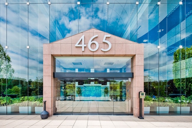
465 Columbus Ave, Thornwood, NY 10594


Current Lease Availabilities
NEARBY LISTINGS FOR SALE OR LEASE
Property Detail
465 Columbus Ave
3489-112-011-00001-014-0000
Subdivision Map Clove Brook
Officebuilding
Westchester
X
New York
36119C0256F
14.000
2025
6.11 AC
2024
West I-287 Corridor
012102
Westchester/So Connecticut
108,201 SF
New York-Jersey City-White Plains, NY-NJ
DEMOGRAPHICS near 465 Columbus Ave
1 Mile
3 Mile
5 Mile
2024 Total Population
6,043
33,873
124,566
2029 Population
5,841
33,102
122,224
Pop Growth 2024-2029
(3.34%)
(2.28%)
(1.88%)
Average Age
43
41
42
2024 Total Households
2,055
10,912
44,171
HH Growth 2024-2029
(3.65%)
(2.55%)
(2.07%)
Median Household Inc
$138,993
$158,853
$139,249
Avg Household Size
2.80
2.80
2.70
2024 Avg HH Vehicles
2.00
2.00
2.00
Median Home Value
$712,417
$739,738
$714,172
Median Year Built
1957
1958
1962
Nearby Places
Map Layers
Map Styles
 Street
 Aerial
- Restaurants
- Banks
- Shops
- Fitness
- Groceries
PUBLIC TRANSPORTATION
COMMUTER RAIL
Mount Pleasant Station (Harlem Line - Metro-North Commuter Railroad Company (Metro-North))
DRIVE
WALK
Distance
Mount Pleasant Station (Harlem Line - Metro-North Commuter Railroad Company (Metro-North))
6 min
2.0 mi
Hawthorne Station (Harlem Line - Metro-North Commuter Railroad Company (Metro-North))
DRIVE
WALK
Distance
Hawthorne Station (Harlem Line - Metro-North Commuter Railroad Company (Metro-North))
8 min
2.7 mi
AIRPORT
Westchester County
DRIVE
WALK
Distance
Westchester County
18 min
8.0 mi
LaGuardia
DRIVE
WALK
Distance
LaGuardia
50 min
33.2 mi
John F Kennedy International
DRIVE
WALK
Distance
John F Kennedy International
60 min
38.8 mi
Freight Ports
NY - Red Hook Container Terminal
DRIVE
WALK
Distance
NY - Red Hook Container Terminal
63 min
41.4 mi
Nearby Properties
Address
Land Use
TOTAL SIZE
Lot Size
Zoning
Address
Land Use
TOTAL SIZE
Lot Size
Zoning
358.83 AC
Address
Land Use
TOTAL SIZE
Lot Size
Zoning
Address
Land Use
TOTAL SIZE
Lot Size
Zoning
29.42 AC
PUD
Address
Land Use
TOTAL SIZE
Lot Size
Zoning
29.14 AC
PUD
Address
Land Use
TOTAL SIZE
Lot Size
Zoning
3.56 AC
PD
Address
Land Use
TOTAL SIZE
Lot Size
Zoning
5.43 AC
R-40
Address
Land Use
TOTAL SIZE
Lot Size
Zoning
196,901 SF
4.76 AC
PD
Address
Land Use
TOTAL SIZE
Lot Size
Zoning
98,800 SF
6.83 AC
PD
Address
Land Use
TOTAL SIZE
Lot Size
Zoning
Address
Land Use
TOTAL SIZE
Lot Size
Zoning
67.38 AC
R-20
Address
Land Use
TOTAL SIZE
Lot Size
Zoning
94,000 SF
4.69 AC
PD
Address
Land Use
TOTAL SIZE
Lot Size
Zoning
Address
Land Use
TOTAL SIZE
Lot Size
Zoning
80,000 SF
3.66 AC
PD
Address
Land Use
TOTAL SIZE
Lot Size
Zoning
87,114 SF
4.89 AC
PD
Address
Land Use
TOTAL SIZE
Lot Size
Zoning
41,600 SF
5.42 AC
PD
Address
Land Use
TOTAL SIZE
Lot Size
Zoning
82,000 SF
3.46 AC
PD
Address
Land Use
TOTAL SIZE
Lot Size
Zoning
61,700 SF
2.94 AC
PD
Address
Land Use
TOTAL SIZE
Lot Size
Zoning
60,000 SF
2.51 AC
PD
Address
Land Use
TOTAL SIZE
Lot Size
Zoning
13,786 SF
88.05 AC
Address
Land Use
TOTAL SIZE
Lot Size
Zoning
74,900 SF
4.10 AC
PD
Address
Land Use
TOTAL SIZE
Lot Size
Zoning
67,200 SF
3.64 AC
PD
Address
Land Use
TOTAL SIZE
Lot Size
Zoning
49,000 SF
3.58 AC
PD
Address
Land Use
TOTAL SIZE
Lot Size
Zoning
3.90 AC
M-14
Address
Land Use
TOTAL SIZE
Lot Size
Zoning
Address
Land Use
TOTAL SIZE
Lot Size
Zoning
94,000 SF
1.78 AC
PD
Address
Land Use
TOTAL SIZE
Lot Size
Zoning
2.55 AC
Address
Land Use
TOTAL SIZE
Lot Size
Zoning
4.48 AC
Address
Land Use
TOTAL SIZE
Lot Size
Zoning
2,822 SF
4.01 AC
Address
Land Use
TOTAL SIZE
Lot Size
Zoning
5.22 AC
R-40
Address
Land Use
TOTAL SIZE
Lot Size
Zoning
32,230 SF
1.29 AC
PD
The World's #1 Commercial Real Estate Marketplace
Connect with us
© 2025 CoStar Group
The information above has been obtained from sources believed reliable. While we do not doubt its accuracy we have not verified it and make no guarantee, warranty or representation about it. It is your responsibility to independently confirm its accuracy and completeness. Any projections, opinions, assumptions, or estimates used are for example only and do not represent the current or future performance of the property. The value of this transaction to you depends on tax and other factors which should be evaluated by your tax, financial, and legal advisors. You and your advisors should conduct a careful, independent investigation of the property to determine to your satisfaction the suitability of the property for your needs.