Property Record
4650 Sw Hollyhock Cir, Corvallis, OR 97333
NEARBY LISTINGS FOR SALE OR LEASE
Property Detail
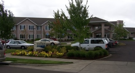
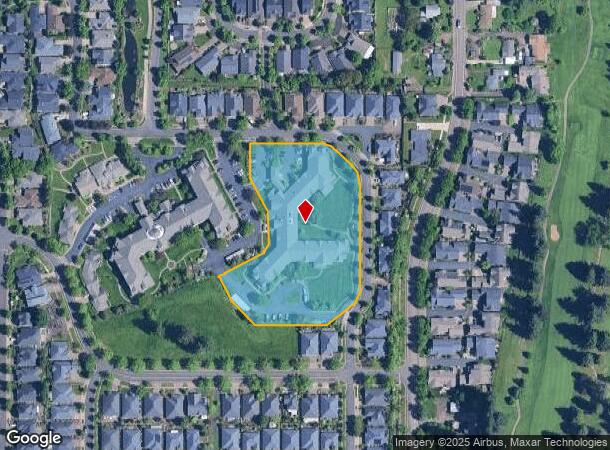
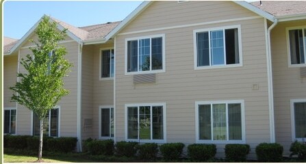
4650 Sw Hollyhock Cir
Corvallis, OR
Stoneybrook Village Phase 1
415789
STONEYBROOK VILLAGE PHASE 1 LOT 53
Commercialbuilding
Benton
X
Oregon
41003C0191F
53
2024
3.40 AC
2025
Oregon West Area
000202
Other Market Areas
76,625 SF
DEMOGRAPHICS near 4650 Sw Hollyhock Cir
1 Mile
3 Mile
5 Mile
2024 Total Population
5,697
47,237
73,644
2029 Population
6,064
49,764
77,591
Pop Growth 2024-2029
+ 6.44%
+ 5.35%
+ 5.36%
Average Age
41
34
37
2024 Total Households
2,502
18,249
29,452
HH Growth 2024-2029
+ 6.75%
+ 6.12%
+ 5.95%
Median Household Inc
$75,445
$54,480
$59,724
Avg Household Size
2.30
2.20
2.30
2024 Avg HH Vehicles
2.00
2.00
2.00
Median Home Value
$465,052
$435,610
$436,384
Median Year Built
1996
1979
1978
Nearby Places
Map Layers
Map Styles
 Street
 Aerial
- Restaurants
- Banks
- Shops
- Fitness
- Groceries
PUBLIC TRANSPORTATION
AIRPORT
Mahlon Sweet Field
DRIVE
WALK
Distance
Mahlon Sweet Field
62 min
37.7 mi
Freight Ports
Port of Portland
DRIVE
WALK
Distance
Port of Portland
115 min
89.3 mi
Nearby Properties
Address
Land Use
TOTAL SIZE
Lot Size
Zoning
Address
Land Use
TOTAL SIZE
Lot Size
Zoning
1,687,456 SF
178.96 AC
OSU
Address
Land Use
TOTAL SIZE
Lot Size
Zoning
84,026 SF
29.97 AC
OSU
Address
Land Use
TOTAL SIZE
Lot Size
Zoning
878,646 SF
26.45 AC
OSU
Address
Land Use
TOTAL SIZE
Lot Size
Zoning
552,129 SF
25.99 AC
RS-12
Address
Land Use
TOTAL SIZE
Lot Size
Zoning
247,098 SF
16.39 AC
OSU
Address
Land Use
TOTAL SIZE
Lot Size
Zoning
321,584 SF
21.48 AC
RS-9
Address
Land Use
TOTAL SIZE
Lot Size
Zoning
45.23 AC
OSU
Address
Land Use
TOTAL SIZE
Lot Size
Zoning
Address
Land Use
TOTAL SIZE
Lot Size
Zoning
292,032 SF
40.52 AC
RS-3.5
Address
Land Use
TOTAL SIZE
Lot Size
Zoning
120,379 SF
11.85 AC
OSU
Address
Land Use
TOTAL SIZE
Lot Size
Zoning
339,006 SF
0.69 AC
RF
Address
Land Use
TOTAL SIZE
Lot Size
Zoning
91,272 SF
1.27 AC
OSU
Address
Land Use
TOTAL SIZE
Lot Size
Zoning
330,693 SF
1.25 AC
MUE
Address
Land Use
TOTAL SIZE
Lot Size
Zoning
122,130 SF
5.64 AC
OSU
Address
Land Use
TOTAL SIZE
Lot Size
Zoning
106,538 SF
4.38 AC
RS-12
Address
Land Use
TOTAL SIZE
Lot Size
Zoning
82,704 SF
7.66 AC
RS-5
Address
Land Use
TOTAL SIZE
Lot Size
Zoning
215,337 SF
16.20 AC
RS-20
Address
Land Use
TOTAL SIZE
Lot Size
Zoning
297,220 SF
2.67 AC
OSU
Address
Land Use
TOTAL SIZE
Lot Size
Zoning
166,415 SF
3.04 AC
OSU
Address
Land Use
TOTAL SIZE
Lot Size
Zoning
137,135 SF
14.80 AC
RTC
Address
Land Use
TOTAL SIZE
Lot Size
Zoning
47,966 SF
2.44 AC
RS-9
Address
Land Use
TOTAL SIZE
Lot Size
Zoning
68,500 SF
10 AC
OSU
Address
Land Use
TOTAL SIZE
Lot Size
Zoning
176,703 SF
3.43 AC
OSU
Address
Land Use
TOTAL SIZE
Lot Size
Zoning
116,863 SF
2.10 AC
OSU
Address
Land Use
TOTAL SIZE
Lot Size
Zoning
81,113 SF
1.81 AC
PD(RS-20)
Address
Land Use
TOTAL SIZE
Lot Size
Zoning
Address
Land Use
TOTAL SIZE
Lot Size
Zoning
241,599 SF
14.33 AC
R-3
Address
Land Use
TOTAL SIZE
Lot Size
Zoning
107,412 SF
9.16 AC
RTC
Address
Land Use
TOTAL SIZE
Lot Size
Zoning
235,104 SF
9.96 AC
PD(RS-20)
Address
Land Use
TOTAL SIZE
Lot Size
Zoning
159,910 SF
6.22 AC
RS-20
The World's #1 Commercial Real Estate Marketplace
Connect with us
© 2025 CoStar Group
The information above has been obtained from sources believed reliable. While we do not doubt its accuracy we have not verified it and make no guarantee, warranty or representation about it. It is your responsibility to independently confirm its accuracy and completeness. Any projections, opinions, assumptions, or estimates used are for example only and do not represent the current or future performance of the property. The value of this transaction to you depends on tax and other factors which should be evaluated by your tax, financial, and legal advisors. You and your advisors should conduct a careful, independent investigation of the property to determine to your satisfaction the suitability of the property for your needs.