Property Record
4653 Table Mountain Dr, Golden, CO 80403
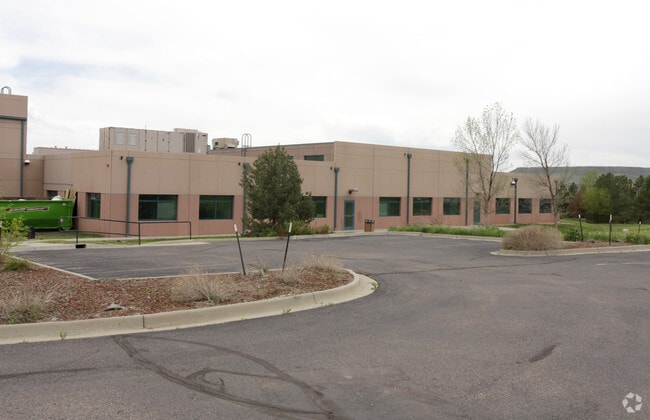

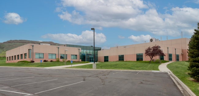

Property Detail
4653 Table Mountain Dr
Denver-Aurora-Centennial, CO
SECTION 24 TOWNSHIP 03 RANGE 70 QTR NW SUBDIVISIONCD 165555 SUBDIVISIONNAME COORS TECHNOLOGY CENTER REPLAT A EX SUR # 1 BLOCK LOT 0009 SIZE: 254699 TRACT VALUE: 5.847
30-242-02-009
JEFFERSON
Industrialgeneral
Colorado
B and X Area of moderate flood hazard, usually the area between the limits of the 100-year and 500-year floods.
9
2025
5.85 AC
2025
West Denver
009842
Denver
50,240 SF
NEARBY LISTINGS FOR SALE OR LEASE
DEMOGRAPHICS near 4653 Table Mountain Dr
1 mile
3 mile
5 mile
2025 Total Population
2,082
45,051
150,088
2030 Population
2,055
44,998
150,092
Pop Growth 2025-2030
(1.30%)
(0.12%)
0.00%
Average Age
44
43
42
2025 Total Households
778
18,078
61,774
HH Growth 2025-2030
(1.41%)
(0.13%)
0.00%
Median Household Inc
$169,444
$131,506
$102,960
Avg Household Size
2.60
2.40
2.30
2025 Avg HH Vehicles
3.00
2.00
2.00
Median Home Value
$888,220
$802,440
$735,536
Median Year Built
1989
1989
1978
Nearby Places
Map Layers
Map Styles
 Street
 Aerial
Transit
 Traffic
 Biking
Places
Listings with unknown addresses are not visible on the map
- Restaurants
- Banks
- Shops
- Fitness
- Groceries
PUBLIC TRANSPORTATION
COMMUTER RAIL
Wheat Ridge - Ward Station Track 1 (Union Station to Wheat Ridge Ward Station - Regional Transportation District)
Drive
Walk
Distance
Wheat Ridge - Ward Station Track 1 (Union Station to Wheat Ridge Ward Station - Regional Transportation District)
9 min
3.3 mi
Arvada Ridge Station Track 1 (Union Station to Wheat Ridge Ward Station - Regional Transportation District)
Drive
Walk
Distance
Arvada Ridge Station Track 1 (Union Station to Wheat Ridge Ward Station - Regional Transportation District)
11 min
5.8 mi
AIRPORT
Denver International
Drive
Walk
Distance
Denver International
44 min
33.4 mi
Freight Ports
Tulsa Port Of Catoosa
Drive
Walk
Distance
Tulsa Port Of Catoosa
741 min
718.9 mi
SALE & LEASE HISTORY
LISTING DATE
SALE/LEASE

Sep 25, 2016
For Lease
Sep 24, 2016
For Sale
May 25, 2018
For Lease
Feb 14, 2017
For Lease
Aug 29, 2022
For Lease
Nearby Properties
Address
Land Use
TOTAL SIZE
Lot Size
Zoning
Address
Land Use
TOTAL SIZE
Lot Size
Zoning
830,160 SF
26.93 AC
Address
Land Use
TOTAL SIZE
Lot Size
Zoning
2,710,724 SF
32.87 AC
Address
Land Use
TOTAL SIZE
Lot Size
Zoning
966,836 SF
84.74 AC
I2
Address
Land Use
TOTAL SIZE
Lot Size
Zoning
117,036 SF
1.38 AC
Address
Land Use
TOTAL SIZE
Lot Size
Zoning
52,103 SF
2.44 AC
Address
Land Use
TOTAL SIZE
Lot Size
Zoning
49,337 SF
4.02 AC
Address
Land Use
TOTAL SIZE
Lot Size
Zoning
72,630 SF
5.08 AC
Address
Land Use
TOTAL SIZE
Lot Size
Zoning
322,105 SF
136.23 AC
Address
Land Use
TOTAL SIZE
Lot Size
Zoning
162,271 SF
8.20 AC
Address
Land Use
TOTAL SIZE
Lot Size
Zoning
353,286 SF
14.49 AC
Address
Land Use
TOTAL SIZE
Lot Size
Zoning
40,163 SF
5.46 AC
Address
Land Use
TOTAL SIZE
Lot Size
Zoning
48,225 SF
1.81 AC
Address
Land Use
TOTAL SIZE
Lot Size
Zoning
187,745 SF
16.25 AC
Address
Land Use
TOTAL SIZE
Lot Size
Zoning
282,190 SF
6.42 AC
PD
Address
Land Use
TOTAL SIZE
Lot Size
Zoning
282,265 SF
80.48 AC
I2
Address
Land Use
TOTAL SIZE
Lot Size
Zoning
39,374 SF
1.20 AC
Address
Land Use
TOTAL SIZE
Lot Size
Zoning
227,132 SF
11.95 AC
Address
Land Use
TOTAL SIZE
Lot Size
Zoning
363,989 SF
30.10 AC
Address
Land Use
TOTAL SIZE
Lot Size
Zoning
520,896 SF
24.42 AC
I1
Address
Land Use
TOTAL SIZE
Lot Size
Zoning
192,500 SF
10.97 AC
Address
Land Use
TOTAL SIZE
Lot Size
Zoning
260,325 SF
13.70 AC
Address
Land Use
TOTAL SIZE
Lot Size
Zoning
109,401 SF
12.19 AC
Address
Land Use
TOTAL SIZE
Lot Size
Zoning
390,157 SF
10.02 AC
Address
Land Use
TOTAL SIZE
Lot Size
Zoning
365,230 SF
12.51 AC
Address
Land Use
TOTAL SIZE
Lot Size
Zoning
454.79 AC
A2
Address
Land Use
TOTAL SIZE
Lot Size
Zoning
299,678 SF
20.79 AC
PD
Address
Land Use
TOTAL SIZE
Lot Size
Zoning
57,453 SF
2.83 AC
Address
Land Use
TOTAL SIZE
Lot Size
Zoning
288,528 SF
12.78 AC
Address
Land Use
TOTAL SIZE
Lot Size
Zoning
128,443 SF
23.81 AC
Address
Land Use
TOTAL SIZE
Lot Size
Zoning
125,884 SF
8.88 AC
The World's #1 Commercial Real Estate Marketplace
Connect with us
© 2026 CoStar Group
The information above has been obtained from sources believed reliable. While we do not doubt its accuracy we have not verified it and make no guarantee, warranty or representation about it. It is your responsibility to independently confirm its accuracy and completeness. Any projections, opinions, assumptions, or estimates used are for example only and do not represent the current or future performance of the property. The value of this transaction to you depends on tax and other factors which should be evaluated by your tax, financial, and legal advisors. You and your advisors should conduct a careful, independent investigation of the property to determine to your satisfaction the suitability of the property for your needs.