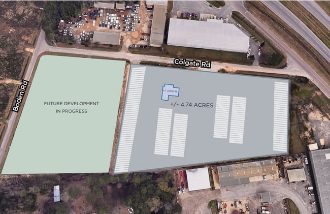
Property Record
4689 Colgate Dr, Mobile, AL 36619

Property Detail
4689 Colgate Dr
Mobile, AL
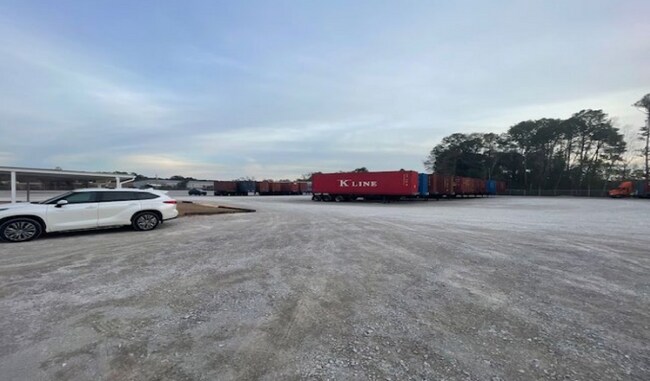
Mobile Logistics Park Unit One
33-06-23-3-000-022.001
LOT A MOBILE LOGISTICS PARK UNIT ONE INSTRUMENT NUMBER 2023021244
Sfr
Mobile
AE
Alabama
01097C0659L
a
2025
4.81 AC
2025
Outlying Mobile County
007000
Mobile
1,508 SF
NEARBY LISTINGS FOR SALE OR LEASE
DEMOGRAPHICS near 4689 Colgate Dr
1 mile
3 mile
5 mile
2024 Total Population
939
20,200
79,429
2029 Population
929
19,875
77,968
Pop Growth 2024-2029
(1.06%)
(1.61%)
(1.84%)
Average Age
44
41
40
2024 Total Households
368
8,219
32,187
HH Growth 2024-2029
(1.36%)
(1.65%)
(1.93%)
Median Household Inc
$48,095
$49,470
$50,930
Avg Household Size
2.40
2.40
2.40
2024 Avg HH Vehicles
2.00
2.00
2.00
Median Home Value
$214,925
$170,003
$169,737
Median Year Built
1974
1978
1979
Nearby Places
Map Layers
Map Styles
 Street
 Aerial
Transit
 Traffic
 Biking
Places
Listings with unknown addresses are not visible on the map
- Restaurants
- Banks
- Shops
- Fitness
- Groceries
PUBLIC TRANSPORTATION
AIRPORT
Mobile International
Drive
Walk
Distance
Mobile International
13 min
7.8 mi
Mobile Regional
Drive
Walk
Distance
Mobile Regional
29 min
13.6 mi
Freight Ports
Port of Mobile
Drive
Walk
Distance
Port of Mobile
16 min
11.2 mi
SALE & LEASE HISTORY
LISTING DATE
SALE/LEASE

Nov 28, 2023
For Sale
Nov 26, 2025
For Lease
Feb 26, 2024
For Sale
Feb 26, 2024
For Sale
Feb 24, 2025
For Lease
Aug 08, 2024
For Sale
Nearby Properties
Address
Land Use
TOTAL SIZE
Lot Size
Zoning
Address
Land Use
TOTAL SIZE
Lot Size
Zoning
85,823 SF
13.26 AC
Address
Land Use
TOTAL SIZE
Lot Size
Zoning
117,000 SF
Address
Land Use
TOTAL SIZE
Lot Size
Zoning
24,255 SF
9.15 AC
Address
Land Use
TOTAL SIZE
Lot Size
Zoning
7,810 SF
15.35 AC
Address
Land Use
TOTAL SIZE
Lot Size
Zoning
37,604 SF
9.10 AC
Address
Land Use
TOTAL SIZE
Lot Size
Zoning
78,750 SF
27.51 AC
Address
Land Use
TOTAL SIZE
Lot Size
Zoning
26,933 SF
82.37 AC
Address
Land Use
TOTAL SIZE
Lot Size
Zoning
18,392 SF
15.69 AC
Address
Land Use
TOTAL SIZE
Lot Size
Zoning
234,275 SF
40.29 AC
Address
Land Use
TOTAL SIZE
Lot Size
Zoning
204,868 SF
22.14 AC
Address
Land Use
TOTAL SIZE
Lot Size
Zoning
27,580 SF
4.69 AC
Address
Land Use
TOTAL SIZE
Lot Size
Zoning
51,610 SF
16.89 AC
Address
Land Use
TOTAL SIZE
Lot Size
Zoning
132,400 SF
23 AC
Address
Land Use
TOTAL SIZE
Lot Size
Zoning
15,476 SF
10.44 AC
Address
Land Use
TOTAL SIZE
Lot Size
Zoning
78,750 SF
24 AC
Address
Land Use
TOTAL SIZE
Lot Size
Zoning
20,000 SF
28.80 AC
Address
Land Use
TOTAL SIZE
Lot Size
Zoning
139,097 SF
11.64 AC
Address
Land Use
TOTAL SIZE
Lot Size
Zoning
66,382 SF
1.71 AC
Address
Land Use
TOTAL SIZE
Lot Size
Zoning
99,076 SF
25 AC
Address
Land Use
TOTAL SIZE
Lot Size
Zoning
110,982 SF
17.46 AC
Address
Land Use
TOTAL SIZE
Lot Size
Zoning
6,880 SF
12.77 AC
Address
Land Use
TOTAL SIZE
Lot Size
Zoning
92,271 SF
15.40 AC
Address
Land Use
TOTAL SIZE
Lot Size
Zoning
94,116 SF
7.11 AC
Address
Land Use
TOTAL SIZE
Lot Size
Zoning
185.25 AC
Address
Land Use
TOTAL SIZE
Lot Size
Zoning
396.69 AC
Address
Land Use
TOTAL SIZE
Lot Size
Zoning
16,452 SF
4.32 AC
Address
Land Use
TOTAL SIZE
Lot Size
Zoning
21,143 SF
7.03 AC
Address
Land Use
TOTAL SIZE
Lot Size
Zoning
74,000 SF
3.46 AC
Address
Land Use
TOTAL SIZE
Lot Size
Zoning
76,560 SF
27.88 AC
Address
Land Use
TOTAL SIZE
Lot Size
Zoning
60,630 SF
6.70 AC
The World's #1 Commercial Real Estate Marketplace
Connect with us
© 2026 CoStar Group
The information above has been obtained from sources believed reliable. While we do not doubt its accuracy we have not verified it and make no guarantee, warranty or representation about it. It is your responsibility to independently confirm its accuracy and completeness. Any projections, opinions, assumptions, or estimates used are for example only and do not represent the current or future performance of the property. The value of this transaction to you depends on tax and other factors which should be evaluated by your tax, financial, and legal advisors. You and your advisors should conduct a careful, independent investigation of the property to determine to your satisfaction the suitability of the property for your needs.