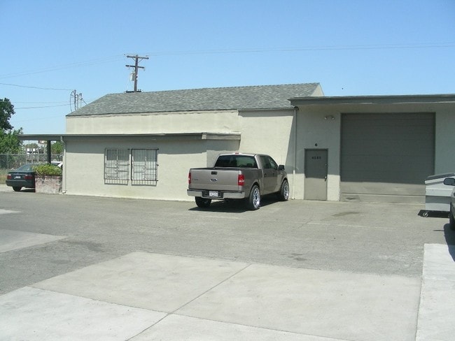
Property Record
4660 E Waterloo Rd, Stockton, CA 95215

Property Detail
4660 E Waterloo Rd
101-021-32
EL RHO DEL CAMPO DE LOS
Warehouse
San Joaquin
IL
California
AH Areas with a 1% annual chance of shallow flooding, usually in the form of a pond, withan average depth ranging from 1 to 3 feet. These areas have a 26% chance of flooding over the life of a 30-year mortgage.
9.88 AC
2025
NE Stockton
2025
Stockton/Modesto
003601
Stockton-Lodi, CA
12,800 SF
NEARBY LISTINGS FOR SALE OR LEASE
DEMOGRAPHICS near 4660 E Waterloo Rd
1 mile
3 mile
5 mile
2024 Total Population
2,152
80,635
254,091
2029 Population
2,218
83,908
264,535
Pop Growth 2024-2029
+ 3.07%
+ 4.06%
+ 4.11%
Average Age
39
36
36
2024 Total Households
728
23,082
77,739
HH Growth 2024-2029
+ 2.88%
+ 4.15%
+ 4.32%
Median Household Inc
$79,654
$67,654
$65,870
Avg Household Size
2.90
3.30
3.10
2024 Avg HH Vehicles
2.00
2.00
2.00
Median Home Value
$438,571
$375,403
$389,127
Median Year Built
1972
1971
1972
Nearby Places
Map Layers
Map Styles
 Street
 Aerial
Transit
 Traffic
 Biking
Places
Listings with unknown addresses are not visible on the map
- Restaurants
- Banks
- Shops
- Fitness
- Groceries
PUBLIC TRANSPORTATION
COMMUTER RAIL
Drive
Walk
Distance
8 min
3.6 mi
Drive
Walk
Distance
9 min
4.6 mi
AIRPORT
Stockton Metro
Drive
Walk
Distance
Stockton Metro
15 min
9.5 mi
SALE & LEASE HISTORY
LISTING DATE
SALE/LEASE

Sep 25, 2016
For Lease
Nov 22, 2024
For Lease
Nearby Properties
Address
Land Use
TOTAL SIZE
Lot Size
Zoning
Address
Land Use
TOTAL SIZE
Lot Size
Zoning
530,700 SF
8.35 AC
Address
Land Use
TOTAL SIZE
Lot Size
Zoning
152,000 SF
1.31 AC
Address
Land Use
TOTAL SIZE
Lot Size
Zoning
9,750 SF
136.94 AC
AU20
Address
Land Use
TOTAL SIZE
Lot Size
Zoning
502,000 SF
19.76 AC
Address
Land Use
TOTAL SIZE
Lot Size
Zoning
652,548 SF
35.24 AC
IL
Address
Land Use
TOTAL SIZE
Lot Size
Zoning
121,574 SF
5.49 AC
RHD
Address
Land Use
TOTAL SIZE
Lot Size
Zoning
47.61 AC
Address
Land Use
TOTAL SIZE
Lot Size
Zoning
1,312 SF
7.44 AC
Address
Land Use
TOTAL SIZE
Lot Size
Zoning
219,572 SF
16.53 AC
IL
Address
Land Use
TOTAL SIZE
Lot Size
Zoning
90,142 SF
26.25 AC
Address
Land Use
TOTAL SIZE
Lot Size
Zoning
62,588 SF
43.56 AC
IW
Address
Land Use
TOTAL SIZE
Lot Size
Zoning
37,846 SF
2.94 AC
Address
Land Use
TOTAL SIZE
Lot Size
Zoning
2.42 AC
Address
Land Use
TOTAL SIZE
Lot Size
Zoning
2,876 SF
10.54 AC
Address
Land Use
TOTAL SIZE
Lot Size
Zoning
5,264 SF
9.82 AC
IL
Address
Land Use
TOTAL SIZE
Lot Size
Zoning
102,190 SF
10.34 AC
Address
Land Use
TOTAL SIZE
Lot Size
Zoning
135,198 SF
13.37 AC
Address
Land Use
TOTAL SIZE
Lot Size
Zoning
95,838 SF
10.10 AC
Address
Land Use
TOTAL SIZE
Lot Size
Zoning
126,108 SF
12.43 AC
Address
Land Use
TOTAL SIZE
Lot Size
Zoning
129,750 SF
8.63 AC
Address
Land Use
TOTAL SIZE
Lot Size
Zoning
261,860 SF
7.48 AC
IW
Address
Land Use
TOTAL SIZE
Lot Size
Zoning
8 AC
IL
Address
Land Use
TOTAL SIZE
Lot Size
Zoning
65,516 SF
10.56 AC
RM
Address
Land Use
TOTAL SIZE
Lot Size
Zoning
5,684 SF
17 AC
Address
Land Use
TOTAL SIZE
Lot Size
Zoning
8,265 SF
2.87 AC
IL
Address
Land Use
TOTAL SIZE
Lot Size
Zoning
10,556 SF
1.15 AC
Address
Land Use
TOTAL SIZE
Lot Size
Zoning
199,500 SF
8.74 AC
IW
Address
Land Use
TOTAL SIZE
Lot Size
Zoning
202,752 SF
9.40 AC
IL
Address
Land Use
TOTAL SIZE
Lot Size
Zoning
3.55 AC
Address
Land Use
TOTAL SIZE
Lot Size
Zoning
46,336 SF
11.08 AC
The World's #1 Commercial Real Estate Marketplace
Connect with us
© 2026 CoStar Group
The information above has been obtained from sources believed reliable. While we do not doubt its accuracy we have not verified it and make no guarantee, warranty or representation about it. It is your responsibility to independently confirm its accuracy and completeness. Any projections, opinions, assumptions, or estimates used are for example only and do not represent the current or future performance of the property. The value of this transaction to you depends on tax and other factors which should be evaluated by your tax, financial, and legal advisors. You and your advisors should conduct a careful, independent investigation of the property to determine to your satisfaction the suitability of the property for your needs.