Property Record
47 Ne 15Th St, Miami, FL 33132
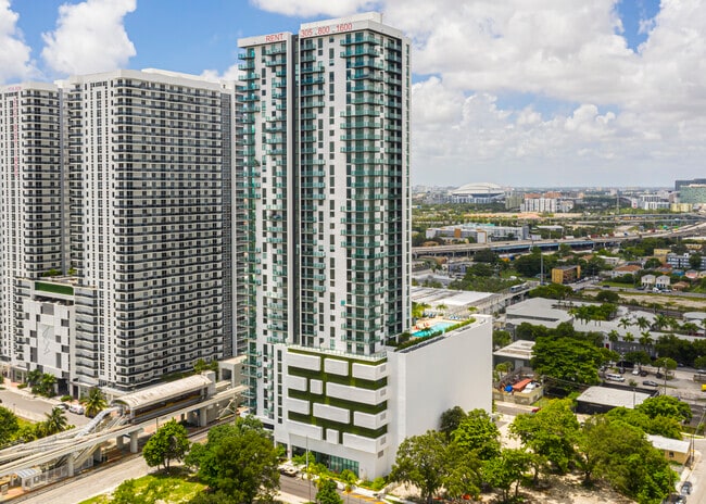

Property Detail
47 Ne 15Th St
01-3136-099-0010
MIAMI PLAZA PB 174-089 T-24192 TR A LOT SIZE 36790 SQ FT M/L FAU 01-3136-005-1010 & 008-0315 0320-0330-0340
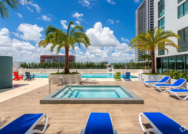
Multifamilydwelling
MIAMI/DADE
6420
Florida
B and X Area of moderate flood hazard, usually the area between the limits of the 100-year and 500-year floods.
6,7
2024
0.85 AC
2025
Media & Entertainment District
002702
South Florida
690,466 SF
Miami-Miami Beach-Kendall, FL
NEARBY LISTINGS FOR SALE OR LEASE
DEMOGRAPHICS near 47 Ne 15Th St
1 mile
3 mile
5 mile
2025 Total Population
52,579
303,038
584,285
2030 Population
58,649
330,102
636,186
Pop Growth 2025-2030
+ 11.54%
+ 8.93%
+ 8.88%
Average Age
38
40
41
2025 Total Households
25,640
134,193
253,685
HH Growth 2025-2030
+ 12.02%
+ 9.19%
+ 9.21%
Median Household Inc
$88,103
$70,511
$67,176
Avg Household Size
1.90
2.10
2.20
2025 Avg HH Vehicles
1.00
1.00
1.00
Median Home Value
$615,239
$641,186
$628,791
Median Year Built
2006
1992
1977
Nearby Places
Map Layers
Map Styles
 Street
 Aerial
Layers
 Traffic
 Biking
Places
Listings with unknown addresses are not visible on the map
- Restaurants
- Banks
- Shops
- Fitness
- Groceries
PUBLIC TRANSPORTATION
TRANSIT/SUBWAY
School Board (Metromover Omni Loop - Miami-Dade Transit (Metrorail/Metromover))
Drive
Walk
Distance
School Board (Metromover Omni Loop - Miami-Dade Transit (Metrorail/Metromover))
1 min
2 min
0.1 mi
Adrienne Arsht Center (Metromover Omni Loop - Miami-Dade Transit (Metrorail/Metromover))
Drive
Walk
Distance
Adrienne Arsht Center (Metromover Omni Loop - Miami-Dade Transit (Metrorail/Metromover))
1 min
8 min
0.4 mi
Eleventh Street (Metromover Omni Loop - Miami-Dade Transit (Metrorail/Metromover))
Drive
Walk
Distance
Eleventh Street (Metromover Omni Loop - Miami-Dade Transit (Metrorail/Metromover))
2 min
11 min
0.6 mi
Park West (Metromover Omni Loop - Miami-Dade Transit (Metrorail/Metromover))
Drive
Walk
Distance
Park West (Metromover Omni Loop - Miami-Dade Transit (Metrorail/Metromover))
2 min
14 min
0.7 mi
Historic Overtown/Lyric Theatre (Metrorail Green Line - Miami-Dade Transit (Metrorail/Metromover))
Drive
Walk
Distance
Historic Overtown/Lyric Theatre (Metrorail Green Line - Miami-Dade Transit (Metrorail/Metromover))
3 min
16 min
0.8 mi
COMMUTER RAIL
Drive
Walk
Distance
3 min
17 min
0.9 mi
Historic Overtown/Lyric Theatre (Metrorail Green Line - Miami-Dade Transit (Metrorail/Metromover))
Drive
Walk
Distance
Historic Overtown/Lyric Theatre (Metrorail Green Line - Miami-Dade Transit (Metrorail/Metromover))
3 min
18 min
1.0 mi
AIRPORT
Miami International
Drive
Walk
Distance
Miami International
23 min
11.4 mi
Fort Lauderdale/Hollywood International
Drive
Walk
Distance
Fort Lauderdale/Hollywood International
33 min
22.4 mi
Nearby Properties
Address
Land Use
TOTAL SIZE
Lot Size
Zoning
Address
Land Use
TOTAL SIZE
Lot Size
Zoning
1,050,691 SF
0.83 AC
6408
Address
Land Use
TOTAL SIZE
Lot Size
Zoning
4,758,614 SF
810.91 AC
8000
Address
Land Use
TOTAL SIZE
Lot Size
Zoning
955,966 SF
38.91 AC
9600
Address
Land Use
TOTAL SIZE
Lot Size
Zoning
2,559,318 SF
2.21 AC
6407
Address
Land Use
TOTAL SIZE
Lot Size
Zoning
2,039,308 SF
2.46 AC
6401
Address
Land Use
TOTAL SIZE
Lot Size
Zoning
928,000 SF
14.30 AC
8000
Address
Land Use
TOTAL SIZE
Lot Size
Zoning
1,110,657 SF
3.83 AC
6407
Address
Land Use
TOTAL SIZE
Lot Size
Zoning
16.13 AC
6100
Address
Land Use
TOTAL SIZE
Lot Size
Zoning
1,346,294 SF
1.89 AC
6408
Address
Land Use
TOTAL SIZE
Lot Size
Zoning
2,403,353 SF
7.37 AC
6100
Address
Land Use
TOTAL SIZE
Lot Size
Zoning
1,938,271 SF
6.62 AC
6402
Address
Land Use
TOTAL SIZE
Lot Size
Zoning
1,162,113 SF
1.92 AC
6407
Address
Land Use
TOTAL SIZE
Lot Size
Zoning
1,075,124 SF
1.61 AC
6405
Address
Land Use
TOTAL SIZE
Lot Size
Zoning
1,544,491 SF
0.97 AC
6401
Address
Land Use
TOTAL SIZE
Lot Size
Zoning
782,686 SF
0.06 AC
6401
Address
Land Use
TOTAL SIZE
Lot Size
Zoning
1,657,362 SF
1.15 AC
6401
Address
Land Use
TOTAL SIZE
Lot Size
Zoning
1,072,012 SF
1.78 AC
6407
Address
Land Use
TOTAL SIZE
Lot Size
Zoning
244,533 SF
3.53 AC
6600
Address
Land Use
TOTAL SIZE
Lot Size
Zoning
694,863 SF
1.90 AC
6407
Address
Land Use
TOTAL SIZE
Lot Size
Zoning
656,821 SF
2.06 AC
6407
Address
Land Use
TOTAL SIZE
Lot Size
Zoning
303,989 SF
1.47 AC
6600
Address
Land Use
TOTAL SIZE
Lot Size
Zoning
416,675 SF
6.48 AC
6401
Address
Land Use
TOTAL SIZE
Lot Size
Zoning
256,089 SF
20.35 AC
7600
Address
Land Use
TOTAL SIZE
Lot Size
Zoning
1,004,006 SF
0.92 AC
6401
Address
Land Use
TOTAL SIZE
Lot Size
Zoning
2.50 AC
6407
Address
Land Use
TOTAL SIZE
Lot Size
Zoning
585,775 SF
1.86 AC
6101
Address
Land Use
TOTAL SIZE
Lot Size
Zoning
868,860 SF
2.14 AC
6402
Address
Land Use
TOTAL SIZE
Lot Size
Zoning
491,308 SF
0.14 AC
6401
Address
Land Use
TOTAL SIZE
Lot Size
Zoning
903,993 SF
0.60 AC
6412
Address
Land Use
TOTAL SIZE
Lot Size
Zoning
872,245 SF
0.56 AC
6401
The World's #1 Commercial Real Estate Marketplace
Connect with us
© 2026 CoStar Group
The information above has been obtained from sources believed reliable. While we do not doubt its accuracy we have not verified it and make no guarantee, warranty or representation about it. It is your responsibility to independently confirm its accuracy and completeness. Any projections, opinions, assumptions, or estimates used are for example only and do not represent the current or future performance of the property. The value of this transaction to you depends on tax and other factors which should be evaluated by your tax, financial, and legal advisors. You and your advisors should conduct a careful, independent investigation of the property to determine to your satisfaction the suitability of the property for your needs.