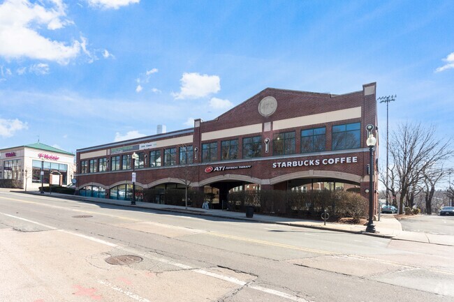
Property Record
470 Washington St, Brighton, MA 02135


Current Lease Availabilities
NEARBY LISTINGS FOR SALE OR LEASE
Property Detail
470 Washington St
Regionalshoppingcenterormallwithanchorstore
Suffolk
X
Massachusetts
25017C0556F
0.94 AC
2025
Allston/Brighton
2025
Boston
000402
Boston-Cambridge-Newton, MA-NH
19,692 SF
BRIG-000000-000022-005159
DEMOGRAPHICS near 470 Washington St
1 Mile
3 Mile
5 Mile
2024 Total Population
42,726
282,070
816,517
2029 Population
40,783
275,559
794,399
Pop Growth 2024-2029
(4.55%)
(2.31%)
(2.71%)
Average Age
36
38
38
2024 Total Households
18,646
116,132
337,557
HH Growth 2024-2029
(5.00%)
(2.52%)
(2.95%)
Median Household Inc
$85,864
$106,638
$103,723
Avg Household Size
2.10
2.20
2.20
2024 Avg HH Vehicles
1.00
1.00
1.00
Median Home Value
$696,062
$948,028
$881,218
Median Year Built
1955
1948
1948
Nearby Places
Map Layers
Map Styles
 Street
 Aerial
- Restaurants
- Banks
- Shops
- Fitness
- Groceries
PUBLIC TRANSPORTATION
TRANSIT/SUBWAY
Boston College Station (Green Line - B - Massachusetts Bay Transportation Authority Subway (The T))
DRIVE
WALK
Distance
Boston College Station (Green Line - B - Massachusetts Bay Transportation Authority Subway (The T))
3 min
15 min
0.8 mi
South Street Station (Green Line - B - Massachusetts Bay Transportation Authority Subway (The T))
DRIVE
WALK
Distance
South Street Station (Green Line - B - Massachusetts Bay Transportation Authority Subway (The T))
3 min
17 min
0.9 mi
Chiswick Road Station (Green Line - B - Massachusetts Bay Transportation Authority Subway (The T))
DRIVE
WALK
Distance
Chiswick Road Station (Green Line - B - Massachusetts Bay Transportation Authority Subway (The T))
3 min
19 min
1.0 mi
COMMUTER RAIL
Newtonville (Framingham/Worcester Line - Massachusetts Bay Transportation Authority Commuter Rail (Purple Line))
DRIVE
WALK
Distance
Newtonville (Framingham/Worcester Line - Massachusetts Bay Transportation Authority Commuter Rail (Purple Line))
5 min
2.6 mi
Boston Landing (Framingham/Worcester Line - MBTA)
DRIVE
WALK
Distance
Boston Landing (Framingham/Worcester Line - MBTA)
6 min
3.5 mi
AIRPORT
General Edward Lawrence Logan International
DRIVE
WALK
Distance
General Edward Lawrence Logan International
18 min
9.4 mi
Freight Ports
Port of Boston
DRIVE
WALK
Distance
Port of Boston
16 min
7.7 mi
Nearby Properties
Address
Land Use
TOTAL SIZE
Lot Size
Zoning
Address
Land Use
TOTAL SIZE
Lot Size
Zoning
439,500 SF
9.21 AC
E
Address
Land Use
TOTAL SIZE
Lot Size
Zoning
150,192 SF
10.27 AC
E
Address
Land Use
TOTAL SIZE
Lot Size
Zoning
530,200 SF
62.08 AC
E
Address
Land Use
TOTAL SIZE
Lot Size
Zoning
142,458 SF
1.67 AC
C-3
Address
Land Use
TOTAL SIZE
Lot Size
Zoning
304,349 SF
1.72 AC
Address
Land Use
TOTAL SIZE
Lot Size
Zoning
3.52 AC
C-3
Address
Land Use
TOTAL SIZE
Lot Size
Zoning
419,722 SF
2.03 AC
RC
Address
Land Use
TOTAL SIZE
Lot Size
Zoning
2.81 AC
O-2
Address
Land Use
TOTAL SIZE
Lot Size
Zoning
254,208 SF
3.83 AC
E
Address
Land Use
TOTAL SIZE
Lot Size
Zoning
4,355 SF
13.12 AC
E
Address
Land Use
TOTAL SIZE
Lot Size
Zoning
336,518 SF
6.15 AC
I-3
Address
Land Use
TOTAL SIZE
Lot Size
Zoning
220,671 SF
2.52 AC
I-2
Address
Land Use
TOTAL SIZE
Lot Size
Zoning
506,534 SF
2.75 AC
C
Address
Land Use
TOTAL SIZE
Lot Size
Zoning
136,025 SF
6.91 AC
C3
Address
Land Use
TOTAL SIZE
Lot Size
Zoning
2.25 AC
SD-12
Address
Land Use
TOTAL SIZE
Lot Size
Zoning
174,764 SF
1.83 AC
C-3
Address
Land Use
TOTAL SIZE
Lot Size
Zoning
176,625 SF
5.76 AC
I-3
Address
Land Use
TOTAL SIZE
Lot Size
Zoning
110,299 SF
0.82 AC
C-3
Address
Land Use
TOTAL SIZE
Lot Size
Zoning
91,500 SF
1.03 AC
SD-5
Address
Land Use
TOTAL SIZE
Lot Size
Zoning
208,468 SF
1.44 AC
RC
Address
Land Use
TOTAL SIZE
Lot Size
Zoning
268,675 SF
1.72 AC
I
Address
Land Use
TOTAL SIZE
Lot Size
Zoning
125,712 SF
1.20 AC
O-2
Address
Land Use
TOTAL SIZE
Lot Size
Zoning
30,170 SF
19 AC
SR2
Address
Land Use
TOTAL SIZE
Lot Size
Zoning
147,997 SF
2.03 AC
GMR2
Address
Land Use
TOTAL SIZE
Lot Size
Zoning
8.18 AC
A-2
Address
Land Use
TOTAL SIZE
Lot Size
Zoning
0.20 AC
E
Address
Land Use
TOTAL SIZE
Lot Size
Zoning
3.68 AC
C-2
Address
Land Use
TOTAL SIZE
Lot Size
Zoning
228,483 SF
7.57 AC
BU1
Address
Land Use
TOTAL SIZE
Lot Size
Zoning
285,456 SF
1.43 AC
E
Address
Land Use
TOTAL SIZE
Lot Size
Zoning
65,891 SF
0.53 AC
BB-1
The World's #1 Commercial Real Estate Marketplace
Connect with us
© 2025 CoStar Group
The information above has been obtained from sources believed reliable. While we do not doubt its accuracy we have not verified it and make no guarantee, warranty or representation about it. It is your responsibility to independently confirm its accuracy and completeness. Any projections, opinions, assumptions, or estimates used are for example only and do not represent the current or future performance of the property. The value of this transaction to you depends on tax and other factors which should be evaluated by your tax, financial, and legal advisors. You and your advisors should conduct a careful, independent investigation of the property to determine to your satisfaction the suitability of the property for your needs.