Property Record
4700 Spring St, La Mesa, CA 91942
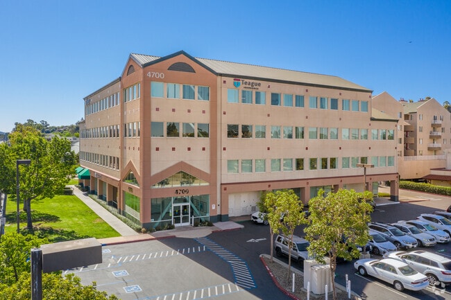

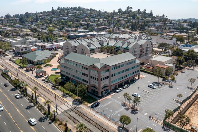

Property Detail
4700 Spring St
470-572-20-01
LOT 3 US 1 PER D91-259856(EX ST)UND INT IN LOTS 1&2 IN TR 012397
Officecondo
San Diego
CD
California
B and X Area of moderate flood hazard, usually the area between the limits of the 100-year and 500-year floods.
3,1,2
2024
4.81 AC
2025
East County
014601
San Diego
43,643 SF
San Diego-Chula Vista-Carlsbad, CA
NEARBY LISTINGS FOR SALE OR LEASE
DEMOGRAPHICS near 4700 Spring St
1 mile
3 mile
5 mile
2025 Total Population
23,144
176,401
468,728
2030 Population
23,355
176,687
468,997
Pop Growth 2025-2030
+ 0.91%
+ 0.16%
+ 0.06%
Average Age
40
39
39
2025 Total Households
9,620
64,458
161,337
HH Growth 2025-2030
+ 0.88%
+ 0.08%
(0.03%)
Median Household Inc
$86,056
$93,583
$90,354
Avg Household Size
2.30
2.60
2.80
2025 Avg HH Vehicles
2.00
2.00
2.00
Median Home Value
$778,463
$776,091
$761,759
Median Year Built
1971
1968
1971
Nearby Places
Map Layers
Map Styles
 Street
 Aerial
Transit
 Traffic
 Biking
Places
Listings with unknown addresses are not visible on the map
- Restaurants
- Banks
- Shops
- Fitness
- Groceries
PUBLIC TRANSPORTATION
TRANSIT/SUBWAY
La Mesa Boulevard (Orange Line - San Diego Metropolitan Transit System Trolley (San Diego Trolley))
Drive
Walk
Distance
La Mesa Boulevard (Orange Line - San Diego Metropolitan Transit System Trolley (San Diego Trolley))
0 min
3 min
0.2 mi
Spring Street (Orange Line - San Diego Metropolitan Transit System Trolley (San Diego Trolley))
Drive
Walk
Distance
Spring Street (Orange Line - San Diego Metropolitan Transit System Trolley (San Diego Trolley))
2 min
18 min
0.8 mi
AIRPORT
San Diego International
Drive
Walk
Distance
San Diego International
19 min
12.7 mi
Freight Ports
Port of San Diego
Drive
Walk
Distance
Port of San Diego
17 min
11.4 mi
SALE & LEASE HISTORY
LISTING DATE
SALE/LEASE

Jul 19, 2022
For Lease
Feb 26, 2019
For Lease
Nearby Properties
Address
Land Use
TOTAL SIZE
Lot Size
Zoning
Address
Land Use
TOTAL SIZE
Lot Size
Zoning
30.38 AC
RB
Address
Land Use
TOTAL SIZE
Lot Size
Zoning
8.23 AC
CUPD-CU-2-
Address
Land Use
TOTAL SIZE
Lot Size
Zoning
62.04 AC
C
Address
Land Use
TOTAL SIZE
Lot Size
Zoning
6.79 AC
C
Address
Land Use
TOTAL SIZE
Lot Size
Zoning
4.77 AC
C
Address
Land Use
TOTAL SIZE
Lot Size
Zoning
5.02 AC
RM-4-10
Address
Land Use
TOTAL SIZE
Lot Size
Zoning
8.65 AC
R3
Address
Land Use
TOTAL SIZE
Lot Size
Zoning
135,165 SF
12.24 AC
CC-5-3
Address
Land Use
TOTAL SIZE
Lot Size
Zoning
92,500 SF
7.05 AC
R3
Address
Land Use
TOTAL SIZE
Lot Size
Zoning
1.54 AC
RM-3-9
Address
Land Use
TOTAL SIZE
Lot Size
Zoning
2.82 AC
R3
Address
Land Use
TOTAL SIZE
Lot Size
Zoning
4.10 AC
RB
Address
Land Use
TOTAL SIZE
Lot Size
Zoning
11.28 AC
C
Address
Land Use
TOTAL SIZE
Lot Size
Zoning
5.47 AC
R3
Address
Land Use
TOTAL SIZE
Lot Size
Zoning
6.14 AC
R3
Address
Land Use
TOTAL SIZE
Lot Size
Zoning
13.48 AC
CC-1-3
Address
Land Use
TOTAL SIZE
Lot Size
Zoning
Address
Land Use
TOTAL SIZE
Lot Size
Zoning
6.31 AC
CC-1-3
Address
Land Use
TOTAL SIZE
Lot Size
Zoning
60,480 SF
0.18 AC
RM-3-9
Address
Land Use
TOTAL SIZE
Lot Size
Zoning
84,900 SF
3.54 AC
R3
Address
Land Use
TOTAL SIZE
Lot Size
Zoning
92,988 SF
6.12 AC
RB
Address
Land Use
TOTAL SIZE
Lot Size
Zoning
5.17 AC
R3
Address
Land Use
TOTAL SIZE
Lot Size
Zoning
89,332 SF
1.14 AC
C
Address
Land Use
TOTAL SIZE
Lot Size
Zoning
4.73 AC
RM-4-10
Address
Land Use
TOTAL SIZE
Lot Size
Zoning
83,198 SF
5 AC
RM-2200
Address
Land Use
TOTAL SIZE
Lot Size
Zoning
6.72 AC
RM-3-7
Address
Land Use
TOTAL SIZE
Lot Size
Zoning
17.63 AC
RM-1-3
Address
Land Use
TOTAL SIZE
Lot Size
Zoning
63,964 SF
5.25 AC
R3
Address
Land Use
TOTAL SIZE
Lot Size
Zoning
97,270 SF
3.40 AC
RM-3-7
Address
Land Use
TOTAL SIZE
Lot Size
Zoning
4.49 AC
RM-5-12
The World's #1 Commercial Real Estate Marketplace
Connect with us
© 2026 CoStar Group
The information above has been obtained from sources believed reliable. While we do not doubt its accuracy we have not verified it and make no guarantee, warranty or representation about it. It is your responsibility to independently confirm its accuracy and completeness. Any projections, opinions, assumptions, or estimates used are for example only and do not represent the current or future performance of the property. The value of this transaction to you depends on tax and other factors which should be evaluated by your tax, financial, and legal advisors. You and your advisors should conduct a careful, independent investigation of the property to determine to your satisfaction the suitability of the property for your needs.