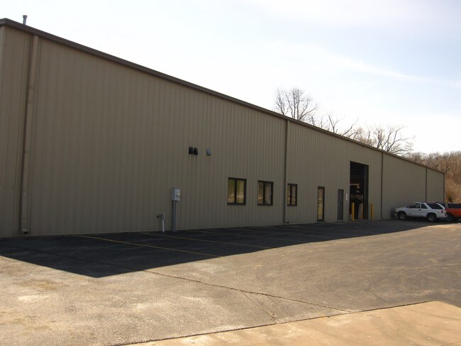
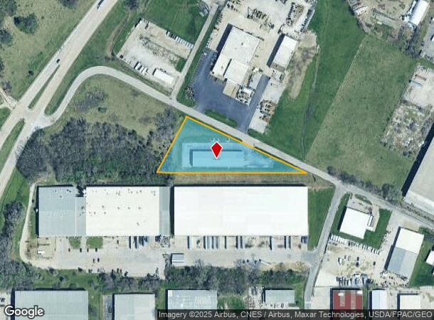
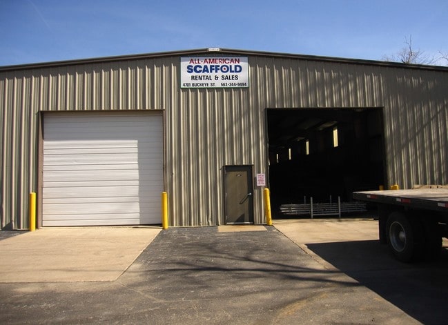
Property Record
4701 Buckeye St, Davenport, IA 52802
NEARBY LISTINGS FOR SALE OR LEASE
-
-
View all Davenport listings for lease on LoopNet.com
Property Detail
4701 Buckeye St
Davenport-Moline-Rock Island, IA-IL
Gartomton Add
20535-01A
GARTOMTON ADD LOT: 001 GARTOMTON ADD
Warehouse
Scott
X
Iowa
19163C0345H
1
2025
1.68 AC
2025
Greater Davenport
012400
Davenport/Moline/Rock Island
12,600 SF
DEMOGRAPHICS near 4701 Buckeye St
1 Mile
3 Mile
5 Mile
2024 Total Population
1,620
20,986
88,873
2029 Population
1,607
20,845
88,143
Pop Growth 2024-2029
(0.80%)
(0.67%)
(0.82%)
Average Age
42
40
39
2024 Total Households
715
8,582
36,594
HH Growth 2024-2029
(0.84%)
(0.76%)
(0.79%)
Median Household Inc
$54,185
$51,584
$50,669
Avg Household Size
2.30
2.30
2.20
2024 Avg HH Vehicles
2.00
2.00
2.00
Median Home Value
$71,369
$99,349
$123,873
Median Year Built
1952
1954
1952
Nearby Places
Map Layers
Map Styles
 Street
 Aerial
- Restaurants
- Banks
- Shops
- Fitness
- Groceries
PUBLIC TRANSPORTATION
AIRPORT
Quad Cities International
DRIVE
WALK
Distance
Quad Cities International
17 min
11.4 mi
Freight Ports
Port Milwaukee
DRIVE
WALK
Distance
Port Milwaukee
249 min
221.7 mi
SALE & LEASE HISTORY
LISTING DATE
SALE/LEASE

Sep 25, 2016
For Lease
Jan 11, 2022
For Lease
Aug 04, 2017
For Sale
Nearby Properties
Address
Land Use
TOTAL SIZE
Lot Size
Zoning
Address
Land Use
TOTAL SIZE
Lot Size
Zoning
352,332 SF
34.16 AC
Address
Land Use
TOTAL SIZE
Lot Size
Zoning
12,648 SF
8.28 AC
Address
Land Use
TOTAL SIZE
Lot Size
Zoning
3,000 SF
59.92 AC
Address
Land Use
TOTAL SIZE
Lot Size
Zoning
70,974 SF
13.14 AC
Address
Land Use
TOTAL SIZE
Lot Size
Zoning
3,283 SF
20 AC
Address
Land Use
TOTAL SIZE
Lot Size
Zoning
1,080 SF
16.40 AC
Address
Land Use
TOTAL SIZE
Lot Size
Zoning
12,969 SF
3.94 AC
Address
Land Use
TOTAL SIZE
Lot Size
Zoning
21,999 SF
22 AC
Address
Land Use
TOTAL SIZE
Lot Size
Zoning
77,870 SF
6.37 AC
Address
Land Use
TOTAL SIZE
Lot Size
Zoning
329,938 SF
Address
Land Use
TOTAL SIZE
Lot Size
Zoning
14,947 SF
26.21 AC
Address
Land Use
TOTAL SIZE
Lot Size
Zoning
408 SF
30.01 AC
Address
Land Use
TOTAL SIZE
Lot Size
Zoning
109,871 SF
7.89 AC
Address
Land Use
TOTAL SIZE
Lot Size
Zoning
2,105 SF
42.52 AC
Address
Land Use
TOTAL SIZE
Lot Size
Zoning
35,126 SF
4.37 AC
Address
Land Use
TOTAL SIZE
Lot Size
Zoning
54,491 SF
14.75 AC
Address
Land Use
TOTAL SIZE
Lot Size
Zoning
186,713 SF
2.89 AC
Address
Land Use
TOTAL SIZE
Lot Size
Zoning
37,149 SF
8.67 AC
Address
Land Use
TOTAL SIZE
Lot Size
Zoning
25,032 SF
2.53 AC
Address
Land Use
TOTAL SIZE
Lot Size
Zoning
4,056 SF
5.16 AC
Address
Land Use
TOTAL SIZE
Lot Size
Zoning
72,230 SF
11.79 AC
Address
Land Use
TOTAL SIZE
Lot Size
Zoning
55,913 SF
11.75 AC
C2
Address
Land Use
TOTAL SIZE
Lot Size
Zoning
1,516 SF
12.18 AC
Address
Land Use
TOTAL SIZE
Lot Size
Zoning
17.43 AC
RI
Address
Land Use
TOTAL SIZE
Lot Size
Zoning
70,148 SF
6.96 AC
Address
Land Use
TOTAL SIZE
Lot Size
Zoning
32,669 SF
2.05 AC
Address
Land Use
TOTAL SIZE
Lot Size
Zoning
1,008 SF
7.56 AC
Address
Land Use
TOTAL SIZE
Lot Size
Zoning
4,520 SF
43.62 AC
R2
Address
Land Use
TOTAL SIZE
Lot Size
Zoning
47,790 SF
6.15 AC
Address
Land Use
TOTAL SIZE
Lot Size
Zoning
1,031 SF
14.10 AC
The World's #1 Commercial Real Estate Marketplace
Connect with us
© 2025 CoStar Group
The information above has been obtained from sources believed reliable. While we do not doubt its accuracy we have not verified it and make no guarantee, warranty or representation about it. It is your responsibility to independently confirm its accuracy and completeness. Any projections, opinions, assumptions, or estimates used are for example only and do not represent the current or future performance of the property. The value of this transaction to you depends on tax and other factors which should be evaluated by your tax, financial, and legal advisors. You and your advisors should conduct a careful, independent investigation of the property to determine to your satisfaction the suitability of the property for your needs.