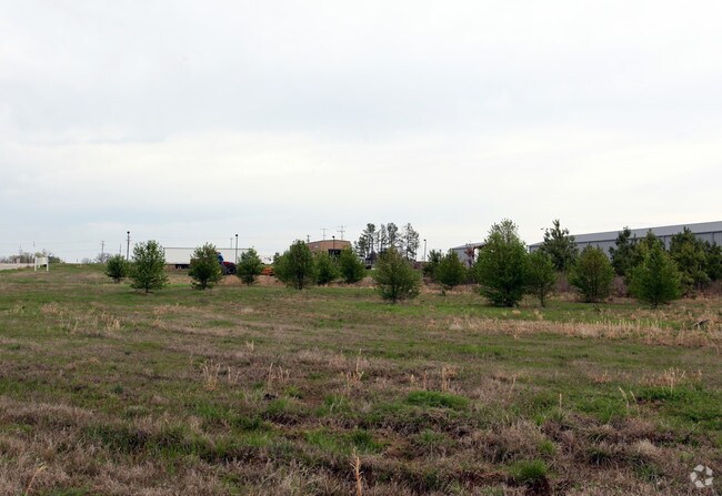
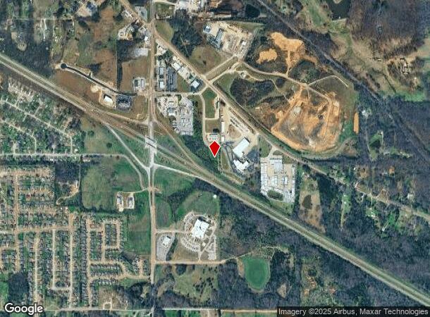
Property Record
4701 Northcentral Way, Olive Branch, MS 38654
NEARBY LISTINGS FOR SALE OR LEASE
Property Detail
4701 Northcentral Way
Memphis, TN-MS-AR
Hacks Cross Business Center Lots 3-6
2061121100000400
HACKS CROSS BUS CENTER LOT 4
Vacantlandnec
DeSoto
X
Mississippi
28033C0120G
4
2025
1.95 AC
2025
DeSoto County
070811
Memphis
DEMOGRAPHICS near 4701 Northcentral Way
1 Mile
3 Mile
5 Mile
2024 Total Population
2,488
22,473
45,357
2029 Population
2,696
24,446
49,225
Pop Growth 2024-2029
+ 8.36%
+ 8.78%
+ 8.53%
Average Age
36
38
38
2024 Total Households
803
7,829
16,134
HH Growth 2024-2029
+ 8.34%
+ 8.79%
+ 8.48%
Median Household Inc
$87,406
$82,862
$82,103
Avg Household Size
2.90
2.80
2.80
2024 Avg HH Vehicles
2.00
2.00
2.00
Median Home Value
$247,524
$239,438
$252,079
Median Year Built
2002
1997
1999
Nearby Places
Map Layers
Map Styles
 Street
 Aerial
- Restaurants
- Banks
- Shops
- Fitness
- Groceries
PUBLIC TRANSPORTATION
AIRPORT
Memphis International
DRIVE
WALK
Distance
Memphis International
23 min
16.1 mi
Freight Ports
Port of Shreveport
DRIVE
WALK
Distance
Port of Shreveport
427 min
389.9 mi
Nearby Properties
Address
Land Use
TOTAL SIZE
Lot Size
Zoning
Address
Land Use
TOTAL SIZE
Lot Size
Zoning
1,150,296 SF
68.41 AC
M-1
Address
Land Use
TOTAL SIZE
Lot Size
Zoning
1,299,800 SF
50.22 AC
M-1
Address
Land Use
TOTAL SIZE
Lot Size
Zoning
860,464 SF
54.55 AC
M-1
Address
Land Use
TOTAL SIZE
Lot Size
Zoning
813,440 SF
38.72 AC
PB
Address
Land Use
TOTAL SIZE
Lot Size
Zoning
927,742 SF
42.73 AC
PB
Address
Land Use
TOTAL SIZE
Lot Size
Zoning
447,008 SF
28.41 AC
PB
Address
Land Use
TOTAL SIZE
Lot Size
Zoning
390,874 SF
122.03 AC
M-1
Address
Land Use
TOTAL SIZE
Lot Size
Zoning
1,082,465 SF
57.74 AC
PB
Address
Land Use
TOTAL SIZE
Lot Size
Zoning
399,672 SF
19.97 AC
M-1
Address
Land Use
TOTAL SIZE
Lot Size
Zoning
377,821 SF
22.08 AC
PB
Address
Land Use
TOTAL SIZE
Lot Size
Zoning
342,001 SF
33.28 AC
M-1
Address
Land Use
TOTAL SIZE
Lot Size
Zoning
301,365 SF
19.98 AC
M-2
Address
Land Use
TOTAL SIZE
Lot Size
Zoning
13,554 SF
15.32 AC
PUD
Address
Land Use
TOTAL SIZE
Lot Size
Zoning
11,097 SF
13.39 AC
PUD
Address
Land Use
TOTAL SIZE
Lot Size
Zoning
259,264 SF
14.31 AC
PB
Address
Land Use
TOTAL SIZE
Lot Size
Zoning
267,880 SF
12.67 AC
PB
Address
Land Use
TOTAL SIZE
Lot Size
Zoning
293,248 SF
14.33 AC
PB
Address
Land Use
TOTAL SIZE
Lot Size
Zoning
12,770 SF
Address
Land Use
TOTAL SIZE
Lot Size
Zoning
160,240 SF
23.89 AC
M-2
Address
Land Use
TOTAL SIZE
Lot Size
Zoning
62,363 SF
12.78 AC
C-2
Address
Land Use
TOTAL SIZE
Lot Size
Zoning
119,796 SF
8.48 AC
M-1
Address
Land Use
TOTAL SIZE
Lot Size
Zoning
50,978 SF
2.96 AC
C-2
Address
Land Use
TOTAL SIZE
Lot Size
Zoning
36.77 AC
C-2
Address
Land Use
TOTAL SIZE
Lot Size
Zoning
12,197 SF
1.34 AC
C-2
Address
Land Use
TOTAL SIZE
Lot Size
Zoning
10,154 SF
5.95 AC
C-4
Address
Land Use
TOTAL SIZE
Lot Size
Zoning
13,004 SF
5.51 AC
PUD
Address
Land Use
TOTAL SIZE
Lot Size
Zoning
21,879 SF
16.33 AC
C-4
Address
Land Use
TOTAL SIZE
Lot Size
Zoning
22,400 SF
5 AC
C-2
Address
Land Use
TOTAL SIZE
Lot Size
Zoning
13,967 SF
10.32 AC
C-2
Address
Land Use
TOTAL SIZE
Lot Size
Zoning
44,072 SF
6.31 AC
C-2
The World's #1 Commercial Real Estate Marketplace
Connect with us
© 2025 CoStar Group
The information above has been obtained from sources believed reliable. While we do not doubt its accuracy we have not verified it and make no guarantee, warranty or representation about it. It is your responsibility to independently confirm its accuracy and completeness. Any projections, opinions, assumptions, or estimates used are for example only and do not represent the current or future performance of the property. The value of this transaction to you depends on tax and other factors which should be evaluated by your tax, financial, and legal advisors. You and your advisors should conduct a careful, independent investigation of the property to determine to your satisfaction the suitability of the property for your needs.